Olney - Olney Muni
Airport details
| Country | United States of America |
| State | Texas |
| Region | K4 |
| Airspace | Ft Worth Ctr |
| Municipality | Young County |
| Elevation | 1273ft (388m) |
| Timezone | GMT -6 |
| Coordinates | 33.35089, -98.81917 |
| Magnetic var | |
| Type | land |
| Available since | X-Plane v10.40 |
| ICAO code | KONY |
| IATA code | n/a |
| FAA code | ONY |
Communication
| Olney Muni CTAF/UNICOM | 122.800 |
Nearby Points of Interest:
Archer County Courthouse and Jail
-Throckmorton County Courthouse and Jail
-Fort Griffin
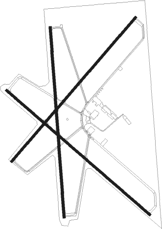
Runway info
Runway 17 / 35  | ||
| length | 1558m (5112ft) | |
| bearing | 180° / 0° | |
| width | 23m (75ft) | |
| surface | asphalt | |
| Runway 4 / 22 | ||
| length | 1556m (5105ft) | |
| bearing | 50° / 230° | |
| width | 23m (75ft) | |
| surface | asphalt | |
| Runway 13 / 31 | ||
| length | 1554m (5098ft) | |
| bearing | 130° / 310° | |
| width | 23m (75ft) | |
| surface | asphalt | |
Nearby beacons
| code | identifier | dist | bearing | frequency |
|---|---|---|---|---|
| GHX | GRAHAM NDB | 19.6 | 120° | 371 |
| SKB | SCOTLAND (WICHITA FALLS) NDB | 30.7 | 37° | 344 |
| SPS | WICHITA FALLS VORTAC | 39.8 | 20° | 112.70 |
| SHP | SHEPPARD (WICHITA FALLS) TACAN | 41.4 | 28° | 110.80 |
| UKW | BOWIE VORTAC | 51.2 | 79° | 117.15 |
| MQP | MILLSAP (MINERAL WELLS) VORTAC | 55.8 | 127° | 117.70 |
Instrument approach procedures
| runway | airway (heading) | route (dist, bearing) |
|---|---|---|
| RW17 | CIYAL (357°) | CIYAL OPEBY (30mi, 358°) 4000ft OPEBY (turn) 4000ft |
| RW17 | KARYN (239°) | KARYN OPEBY (21mi, 262°) 4000ft |
| RW17 | NIFDE (143°) | NIFDE OPEBY (14mi, 118°) 4000ft |
| RW17 | POSTE (188°) | POSTE OPEBY (6mi, 201°) 4000ft |
| RNAV | OPEBY 4000ft LIEGE (6mi, 180°) 2800ft REGKO (3mi, 180°) 1920ft KONY (2mi, 179°) 1315ft (5847mi, 109°) 1800ft KARYN (5825mi, 289°) 5000ft KARYN (turn) | |
| RW35 | AJAHO (45°) | AJAHO HIKTU (12mi, 79°) 3800ft |
| RW35 | GACEB (347°) | GACEB HIKTU (7mi, 324°) 3800ft |
| RW35 | POSTE (188°) | POSTE HIKTU (29mi, 185°) 3800ft HIKTU (turn) 3800ft |
| RNAV | HIKTU 3800ft BEGCA (6mi, 0°) 2800ft NIFYE (3mi, 0°) 1840ft KONY (2mi, 2°) 1301ft (5847mi, 109°) 1800ft POSTE (5844mi, 289°) 5000ft POSTE (turn) |
Disclaimer
The information on this website is not for real aviation. Use this data with the X-Plane flight simulator only! Data taken with kind consent from X-Plane 12 source code and data files. Content is subject to change without notice.