Orange - Orange Muni
Airport details
| Country | United States of America |
| State | Massachusetts |
| Region | K6 |
| Airspace | Boston Ctr |
| Municipality | Orange |
| Elevation | 555ft (169m) |
| Timezone | GMT -5 |
| Coordinates | 42.57000, -72.28850 |
| Magnetic var | |
| Type | land |
| Available since | X-Plane v10.40 |
| ICAO code | KORE |
| IATA code | n/a |
| FAA code | ORE |
Communication
| Orange Muni ASOS | 135.675 |
| Orange Muni CTAF/Unicom | 122.800 |
Nearby Points of Interest:
Whitaker-Clary House
-Old Athol High School
-Holland-Towne House
-Prescott Town House
-Petersham Common Historic District
-Phillipston Center Historic District
-Metacomet-Monadnock Trail
-Searles Hill Cemetery
-Templeton Developmental Center
-District No. 4 School
-Gay Farm
-District No. 5 School
-Simeon Alexander, Jr., House
-Moore's Corner Historic District
-Baldwinville Village Historic District
-Northfield Main Street Historic District
-King Philip's Hill
-Pine Street School
-South School
-Montague Center Historic District
-Richmond School House No. 6
-Leverett Center Historic District
-Richmond Town Hall
-Vernon District Schoolhouse No. 4
-Veterans' Memorial Hall
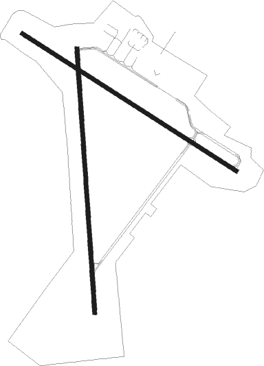
Runway info
Runway 1 / 19  | ||
| length | 1526m (5007ft) | |
| bearing | 1° / 181° | |
| width | 23m (75ft) | |
| surface | asphalt | |
| displ threshold | 30m (98ft) / 244m (801ft) | |
| Runway 14 / 32 | ||
| length | 1461m (4793ft) | |
| bearing | 119° / 299° | |
| width | 23m (75ft) | |
| surface | asphalt | |
| displ threshold | 0m (0ft) / 393m (1289ft) | |
Nearby beacons
| code | identifier | dist | bearing | frequency |
|---|---|---|---|---|
| GDM | GARDNER VOR/DME | 10.2 | 96° | 110.60 |
| EEN | DME | 13.4 | 359° | 109.40 |
| CEF | WESTOVER(SPRINGFIELD/CHIC TACAN | 24.7 | 213° | 114 |
| BAF | BARNES (WESTFIELD/SPRINGF VORTAC | 30.9 | 226° | 113 |
| CTR | CHESTER VOR/DME | 33.7 | 247° | 115.10 |
| MJ | FITZY (MANCHESTER) NDB | 37.8 | 69° | 209 |
| PUT | PUTNAM VOR/DME | 41.8 | 144° | 117.40 |
| MHT | MANCHESTER VOR/DME | 44.3 | 72° | 114.40 |
| CNH | CLAREMONT NDB | 48.1 | 354° | 233 |
| CO | EPSOM (CONCORD) NDB | 49.4 | 57° | 216 |
| CON | CONCORD VOR/DME | 50 | 48° | 112.90 |
| HFD | HARTFORD VOR/DME | 56.9 | 196° | 114.90 |
| PVD | PROVIDENCE VOR/DME | 63.5 | 135° | 115.60 |
| RUT | DME | 64.3 | 325° | 111 |
| LC | BLNAP (LACONIA) NDB | 66.7 | 38° | 328 |
Instrument approach procedures
| runway | airway (heading) | route (dist, bearing) |
|---|---|---|
| RW32 | BRONC (276°) | BRONC HUTIN (17mi, 263°) 3300ft |
| RW32 | GLYDE (302°) | GLYDE HUTIN (18mi, 305°) 3300ft |
| RW32 | JOHNZ (256°) | JOHNZ HUTIN (24mi, 239°) 3300ft |
| RW32 | SPENO (335°) | SPENO HUTIN (12mi, 16°) 3300ft |
| RW32 | WARIC (105°) | WARIC HUTIN (21mi, 111°) 3300ft HUTIN (turn) 3300ft |
| RNAV | HUTIN 3300ft OMASS (5mi, 299°) 2500ft ZUGEG (2mi, 299°) 1600ft KORE (3mi, 297°) 590ft (4628mi, 120°) 873ft CIGPA (4630mi, 300°) WARIC (8mi, 280°) 3500ft WARIC (turn) |
Disclaimer
The information on this website is not for real aviation. Use this data with the X-Plane flight simulator only! Data taken with kind consent from X-Plane 12 source code and data files. Content is subject to change without notice.