Norfolk - Norfolk Intl
Airport details
| Country | United States of America |
| State | Virginia |
| Region | K6 |
| Airspace | Washington Ctr |
| Municipality | Norfolk |
| Elevation | 21ft (6m) |
| Timezone | GMT -5 |
| Coordinates | 36.89461, -76.20123 |
| Magnetic var | |
| Type | land |
| Available since | X-Plane v10.40 |
| ICAO code | KORF |
| IATA code | ORF |
| FAA code | ORF |
Communication
| Norfolk Intl ATIS | 127.150 |
| Norfolk Intl Clearance DEL | 118.500 |
| Norfolk Intl Ground Control | 121.900 |
| Norfolk Intl Tower | 120.800 |
| Norfolk Intl Approach | 118.900 |
| Norfolk Intl Approach | 119.600 |
| Norfolk Intl Approach | 124.825 |
| Norfolk Intl Approach | 125.700 |
| Norfolk Intl Departure | 125.200 |
Approach frequencies
| ILS-cat-I | RW23 | 109.1 | 18.00mi |
| ILS-cat-I | RW05 | 109.1 | 18.00mi |
| 3° GS | RW23 | 109.1 | 18.00mi |
| 3° GS | RW05 | 109.1 | 18.00mi |
Nearby Points of Interest:
Weblin House
-Poplar Hall (Norfolk, Virginia)
-Ballentine Place Historic District
-Lafayette Residence Park
-Lynnhaven House
-The Hermitage
-Thomas Murray House
-American Cigar Company
-Pembroke Manor
-Talbot Hall
-Adam Thoroughgood House
-Williamston-Woodland Historic District
-Southern Bagging Company
-Ferry Plantation House
-Attucks Theatre
-Pleasant Hall
-Lambert's Point Knitting Mill
-St. Peter's Episcopal Church (Norfolk, Virginia)
-Queen Street Baptist Church
-Norfolk and Western Railroad Historic District
-St. John's African Methodist Episcopal Church (Norfolk, Virginia)
-Norfolk Auto Row Historic District
-Basilica of Saint Mary of the Immaculate Conception, Norfolk
-James Blair Junior High School
-Willoughby-Baylor House
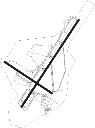
Runway info
Runway 5 / 23  | ||
| length | 2746m (9009ft) | |
| bearing | 44° / 224° | |
| width | 46m (150ft) | |
| surface | asphalt | |
| displ threshold | 305m (1001ft) / 0m (0ft) | |
| blast zone | 61m (200ft) / 61m (200ft) | |
| Runway 14 / 32 | ||
| length | 1485m (4872ft) | |
| bearing | 122° / 302° | |
| width | 46m (150ft) | |
| surface | asphalt | |
| displ threshold | 175m (574ft) / 0m (0ft) | |
Nearby beacons
| code | identifier | dist | bearing | frequency |
|---|---|---|---|---|
| ORF | NORFOLK VORTAC | 0.1 | 162° | 116.90 |
| OR | INGLE (NORFOLK) NDB | 4 | 223° | 329 |
| NGU | CHAMBERS (NORFOLK) TACAN | 4.5 | 301° | 113.95 |
| NTU | OCEANA TACAN | 8.9 | 113° | 116.60 |
| NFE | CHESAPEAKE TACAN | 12.2 | 162° | 108.25 |
| LFI | LANGLEY (HAMPTON) TACAN | 13.7 | 320° | 112.30 |
| CCV | CAPE CHARLES VORTAC | 28.8 | 24° | 112.20 |
| ECG | ELIZABETH CITY VOR/DME | 38.2 | 178° | 112.50 |
| LLW | WOODVILLE (ELIZABETH CITY) NDB | 38.2 | 189° | 254 |
| AKQ | WAKEFIELD NDB | 38.7 | 276° | 274 |
| FKN | FRANKLIN VORTAC | 40.4 | 257° | 110.60 |
| HCM | HARCUM VORTAC | 41.2 | 317° | 108.80 |
| CVI | COFIELD VORTAC | 45 | 232° | 114.60 |
| HPW | HOPEWELL VORTAC | 50.9 | 295° | 112 |
| RBX | WRIGHT BROTHERS (MANTEO) VOR/DME | 63.3 | 153° | 111.60 |
| MQI | MANTEO NDB | 63.6 | 153° | 370 |
Departure and arrival routes
| Transition altitude | 18000ft |
| Transition level | 18000ft |
| STAR starting points | distance | inbound heading | |
|---|---|---|---|
| ALL | |||
| DRONE2 | 31.5 | 52° | |
| TERKS2 | 151.1 | 109° | |
Instrument approach procedures
| runway | airway (heading) | route (dist, bearing) |
|---|---|---|
| RW05-Y | CALEY (44°) | CALEY 1600ft COKLI (5mi, 44°) 1600ft CROOM (2mi, 44°) 1200ft |
| RW05-Y | OMRIE (211°) | OMRIE 5000ft RILLO (12mi, 219°) 5000ft MERFE (6mi, 219°) 5000ft CEGLI (4mi, 245°) 3600ft CROOM (4mi, 132°) 1200ft |
| RNAV | CROOM 1200ft KORF (4mi, 43°) 77ft TECHI (7mi, 44°) OUTLA (23mi, 18°) 2000ft OUTLA (turn) | |
| RW05-Z | DRONE (52°) | DRONE CALEY (20mi, 57°) 3500ft |
| RW05-Z | ECG (358°) | ECG ARDEB (23mi, 328°) 3500ft CALEY (9mi, 15°) 3500ft |
| RW05-Z | WAIKS (100°) | WAIKS CALEY (39mi, 113°) 3500ft |
| RNAV | CALEY 3500ft CROOM (8mi, 44°) 1200ft KORF (4mi, 43°) 77ft (4745mi, 116°) 226ft TECHI (4741mi, 296°) OUTLA (23mi, 18°) 2000ft OUTLA (turn) | |
| RW14 | CCV (204°) | CCV CUBEL (24mi, 234°) 2000ft FIDAR (5mi, 191°) 2000ft |
| RW14 | DEEMS (52°) | DEEMS HAMKI (12mi, 333°) 2500ft FIDAR (7mi, 55°) 2000ft |
| RW14 | HCM (137°) | HCM CUBEL (28mi, 136°) 2000ft FIDAR (5mi, 191°) 2000ft |
| RNAV | FIDAR 2000ft JADEX (5mi, 122°) 1700ft KORF (6mi, 120°) 55ft (4745mi, 116°) 427ft JIMMY (4740mi, 296°) 2000ft JIMMY (turn) | |
| RW23-Y | GUMPP (23°) | GUMPP 5000ft DULTS (7mi, 49°) 5000ft GUTLE (6mi, 48°) 3200ft HUXOL (4mi, 337°) 1900ft BAAGN (2mi, 253°) 1200ft |
| RW23-Y | OMRIE (211°) | OMRIE JHALL (8mi, 190°) 3000ft BAAGN (7mi, 224°) 1200ft |
| RNAV | BAAGN 1200ft KORF (4mi, 225°) 71ft CALEY (12mi, 224°) 2000ft CALEY (turn) | |
| RW23-Z | CCV (204°) | CCV OMRIE (10mi, 190°) 5000ft JHALL (8mi, 190°) 3000ft |
| RW23-Z | TERKS (153°) | TERKS OMRIE (25mi, 117°) 5000ft JHALL (8mi, 190°) 3000ft |
| RNAV | JHALL 3000ft BAAGN (7mi, 224°) 1200ft KORF (4mi, 225°) 71ft (4745mi, 116°) 226ft CALEY (4750mi, 296°) 2000ft CALEY (turn) | |
| RW32 | CCV (204°) | CCV JEBAT (29mi, 179°) 2000ft FAMEX (5mi, 224°) 2000ft |
| RW32 | SUNNS (34°) | SUNNS HELBA (26mi, 53°) 2000ft FAMEX (5mi, 44°) 2000ft |
| RNAV | FAMEX 2000ft EVAPE (5mi, 302°) 1300ft KORF (4mi, 305°) 57ft (4745mi, 116°) 427ft CERIN (4745mi, 296°) JIMMY (12mi, 44°) 2000ft JIMMY (turn) |
Holding patterns
| STAR name | hold at | type | turn | heading* | altitude | leg | speed limit |
|---|---|---|---|---|---|---|---|
| DRONE2 | DRONE | VHF | right | 233 (53)° | 1.0min timed | ICAO rules | |
| *) magnetic outbound (inbound) holding course | |||||||
Disclaimer
The information on this website is not for real aviation. Use this data with the X-Plane flight simulator only! Data taken with kind consent from X-Plane 12 source code and data files. Content is subject to change without notice.