North Bend - Southwest Oregon Regl
Airport details
| Country | United States of America |
| State | Oregon |
| Region | K1 |
| Airspace | Seattle Ctr |
| Municipality | North Bend |
| Elevation | 17ft (5m) |
| Timezone | GMT -8 |
| Coordinates | 43.41694, -124.24702 |
| Magnetic var | |
| Type | land |
| Available since | X-Plane v10.40 |
| ICAO code | KOTH |
| IATA code | OTH |
| FAA code | OTH |
Communication
| Southwest Oregon Regl ATIS | 135.075 |
| Southwest Oregon Regl CTAF | 118.450 |
| Southwest Oregon Regl Ground | 127.100 |
| Southwest Oregon Regl Tower | 118.450 |
Approach frequencies
| ILS-cat-I | RW05 | 108.5 | 18.00mi |
| 3° GS | RW05 | 108.5 | 18.00mi |
Nearby Points of Interest:
Conde McCullough Memorial Bridge
-J. S. Coke Building
-Coos Bay National Bank Building
-Chandler Hotel and Annex
-Marshfield Elks Temple
-St. James Episcopal Church
-Umpqua River Bridge
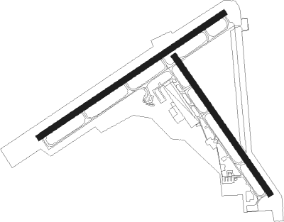
Runway info
Runway 13 / 31  | ||
| length | 1366m (4482ft) | |
| bearing | 141° / 321° | |
| width | 46m (150ft) | |
| surface | asphalt | |
| blast zone | 150m (492ft) / 0m (0ft) | |
| Runway 4 / 22 | ||
| length | 1821m (5974ft) | |
| bearing | 68° / 248° | |
| width | 46m (150ft) | |
| surface | asphalt | |
| displ threshold | 0m (0ft) / 201m (659ft) | |
| blast zone | 0m (0ft) / 104m (341ft) | |
Nearby beacons
| code | identifier | dist | bearing | frequency |
|---|---|---|---|---|
| OT | EMIRE (NORTH BEND) NDB | 3 | 250° | 378 |
| OTH | NORTH BEND VOR/DME | 3.4 | 91° | 112.10 |
| RBG | ROSEBURG VOR/DME | 41.5 | 105° | 108.20 |
Departure and arrival routes
| Transition altitude | 18000ft |
| Transition level | 18000ft |
| SID end points | distance | outbound heading | |
|---|---|---|---|
| RW05 | |||
| OTH7 | 17mi | 61° | |
| RW13 | |||
| OTH7 | 17mi | 61° | |
| RW23 | |||
| OTH7 | 17mi | 61° | |
| RW31 | |||
| OTH7 | 17mi | 61° | |
Instrument approach procedures
| runway | airway (heading) | route (dist, bearing) |
|---|---|---|
| RW05-Y | LUPCI (346°) | LUPCI GAMLL (12mi, 281°) 3400ft MITUE (8mi, 327°) 2400ft |
| RW05-Y | RARES (223°) | RARES MITUE (30mi, 234°) 4100ft MITUE (turn) 2400ft |
| RNAV | MITUE 2400ft OXVAK (8mi, 68°) 1300ft KOTH (4mi, 70°) 67ft (6854mi, 109°) 319ft RUNUE (6852mi, 289°) RARES (15mi, 39°) 6000ft RARES (turn) 6000ft | |
| RW05-Z | DEROY (298°) | DEROY JISDI (11mi, 269°) 3600ft HEKNO (5mi, 271°) 2500ft PIVLY (3mi, 291°) 2400ft FOGIX (5mi, 16°) 1900ft OXVAK (2mi, 68°) 1300ft |
| RW05-Z | GAMMA (198°) | GAMMA KISEY (19mi, 221°) 3300ft HOTLY (4mi, 248°) 2800ft FOGIX (6mi, 142°) 1900ft OXVAK (2mi, 68°) 1300ft |
| RW05-Z | LEDGE (349°) | LEDGE NUJNI (8mi, 313°) 2500ft PIVLY (8mi, 314°) 2400ft FOGIX (5mi, 16°) 1900ft OXVAK (2mi, 68°) 1300ft |
| RW05-Z | OTH (271°) | OTH HIVOR (6mi, 225°) 2500ft IPOVY (3mi, 225°) 2500ft HEKNO (3mi, 250°) 2500ft PIVLY (3mi, 291°) 2400ft FOGIX (5mi, 16°) 1900ft OXVAK (2mi, 68°) 1300ft |
| RW05-Z | RARES (223°) | RARES KISEY (19mi, 243°) 3300ft HOTLY (4mi, 248°) 2800ft FOGIX (6mi, 142°) 1900ft OXVAK (2mi, 68°) 1300ft |
| RW05-Z | SCOTY (241°) | SCOTY KISEY (20mi, 255°) 3300ft HOTLY (4mi, 248°) 2800ft FOGIX (6mi, 142°) 1900ft OXVAK (2mi, 68°) 1300ft |
| RW05-Z | SOZKY (282°) | SOZKY JISDI (15mi, 257°) 3600ft HEKNO (5mi, 271°) 2500ft PIVLY (3mi, 291°) 2400ft FOGIX (5mi, 16°) 1900ft OXVAK (2mi, 68°) 1300ft |
| RNAV | OXVAK 1300ft KOTH (4mi, 70°) 67ft EJLEL (8mi, 67°) ERQAS (7mi, 283°) OTH (7mi, 145°) 3300ft OTH (turn) |
Disclaimer
The information on this website is not for real aviation. Use this data with the X-Plane flight simulator only! Data taken with kind consent from X-Plane 12 source code and data files. Content is subject to change without notice.