Norwood - Norwood Memorial
Airport details
| Country | United States of America |
| State | Massachusetts |
| Region | K6 |
| Airspace | Boston Ctr |
| Municipality | Norwood |
| Elevation | 48ft (15m) |
| Timezone | GMT -5 |
| Coordinates | 42.19053, -71.17294 |
| Magnetic var | |
| Type | land |
| Available since | X-Plane v10.40 |
| ICAO code | KOWD |
| IATA code | OWD |
| FAA code | OWD |
Communication
| Norwood Memorial NORWOOD ATIS | 119.950 |
| Norwood Memorial NORWOOD CTAF | 126.000 |
| Norwood Memorial NORWOOD CLEARANCE DELIVERY | 121.800 |
| Norwood Memorial NORWOOD TOWER | 126.000 |
| Norwood Memorial BOSTON APCH/Departure | 124.100 |
Approach frequencies
| LOC | RW35 | 108.3 | 18.00mi |
Nearby Points of Interest:
Norwood Memorial Municipal Building
-Fred Holland Day House
-Canton Corner Historic District
-Canton Viaduct
-Parson Barnard House
-Redman Farm House
-Blue Hill Meteorological Observatory
-Old Barn
-Brookwood Farm
-Comfort Station
-Fisher School-High Street Historic District
-Endicott Estate
-Wakefield Estate
-Ames Schoolhouse
-Cobb's Tavern
-Colburn School-High Street Historic District
-Neponset Valley Parkway
-Dedham Village Historic District
-Norfolk County Courthouse
-Refreshment Pavilion
-Metropolitan District Commission Stable
-Blue Hills Headquarters
-Ponkapoag Camp of Appalachian Mountain Club
-Suffolk Resolves House
-Brandeis University President's House
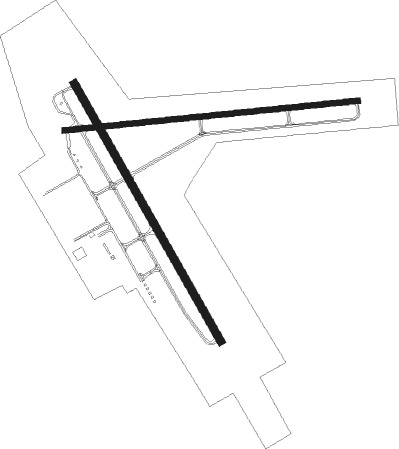
Runway info
Runway 17 / 35  | ||
| length | 1223m (4012ft) | |
| bearing | 148° / 328° | |
| width | 30m (100ft) | |
| surface | asphalt | |
| Runway 10 / 28 | ||
| length | 1219m (3999ft) | |
| bearing | 89° / 269° | |
| width | 23m (75ft) | |
| surface | asphalt | |
| displ threshold | 301m (988ft) / 65m (213ft) | |
Nearby beacons
| code | identifier | dist | bearing | frequency |
|---|---|---|---|---|
| OW | STOGE (NORWOOD) NDB | 4.6 | 148° | 397 |
| BOS | BOSTON VOR/DME | 12.9 | 48° | 112.70 |
| PVD | PROVIDENCE VOR/DME | 30.2 | 209° | 115.60 |
| PUT | PUTNAM VOR/DME | 33 | 251° | 117.40 |
| LWM | DME | 33.2 | 8° | 112.50 |
| MHT | MANCHESTER VOR/DME | 41.6 | 344° | 114.40 |
| PVC | PROVINCETOWN NDB | 42.9 | 97° | 389 |
| FMH | OTIS (FALMOUTH) TACAN | 43.4 | 129° | 115.80 |
| MJ | FITZY (MANCHESTER) NDB | 43.4 | 332° | 209 |
| GDM | GARDNER VOR/DME | 44.7 | 292° | 110.60 |
| HY | BOGEY (HYANNIS) NDB | 51.8 | 116° | 342 |
| ORW | NORWICH VOR/DME | 53 | 233° | 110 |
| MVY | MARTHA'S VINEYARD VOR/DME | 53.8 | 145° | 114.50 |
| PSM | (PORTSMOUTH) DME | 55.7 | 21° | 116.50 |
| CO | EPSOM (CONCORD) NDB | 57 | 343° | 216 |
| GON | GROTON VOR/DME | 64.9 | 226° | 110.85 |
Departure and arrival routes
| Transition altitude | 18000ft |
| Transition level | 18000ft |
| SID end points | distance | outbound heading | |
|---|---|---|---|
| RW10 | |||
| OWD3 | 22mi | 278° | |
| RW17 | |||
| OWD3 | 22mi | 278° | |
| RW28 | |||
| OWD3 | 22mi | 278° | |
| RW35 | |||
| OWD3 | 22mi | 278° | |
| STAR starting points | distance | inbound heading | |
|---|---|---|---|
| ALL | |||
| WOONS2 | 53.0 | 53° | |
Instrument approach procedures
| runway | airway (heading) | route (dist, bearing) |
|---|---|---|
| RW35 | BURDY (317°) | BURDY CURLI (6mi, 298°) 3000ft |
| RW35 | WOONS (54°) | WOONS DODNE (15mi, 85°) 3000ft CURLI (5mi, 71°) 3000ft |
| RNAV | CURLI 3000ft CUPUG (6mi, 328°) 1700ft FIGOL (3mi, 328°) 600ft KOWD (2mi, 332°) 87ft (4574mi, 121°) 344ft DEGEY (4576mi, 301°) WHYBE (10mi, 276°) 3000ft WHYBE (turn) 3000ft |
Holding patterns
| STAR name | hold at | type | turn | heading* | altitude | leg | speed limit |
|---|---|---|---|---|---|---|---|
| WOONS2 | ORW | NDB | left | 238 (58)° | 2500ft - 17500ft | 1.0min timed | ICAO rules |
| WOONS2 | WOONS | VHF | left | 240 (60)° | < 17999ft | 1.0min timed | ICAO rules |
| *) magnetic outbound (inbound) holding course | |||||||
Disclaimer
The information on this website is not for real aviation. Use this data with the X-Plane flight simulator only! Data taken with kind consent from X-Plane 12 source code and data files. Content is subject to change without notice.