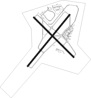
Paducah - Barkley Rgnl
Airport details
| Country | United States of America |
| State | Kentucky |
| Region | K5 |
| Airspace | Memphis Ctr |
| Municipality | McCracken County |
| Elevation | 410ft (125m) |
| Timezone | GMT -6 |
| Coordinates | 37.06029, -88.77296 |
| Magnetic var | |
| Type | land |
| Available since | X-Plane v10.35 |
| ICAO code | KPAH |
| IATA code | PAH |
| FAA code | PAH |
Communication
| BARKLEY RGNL ASOS | 118.375 |
| BARKLEY RGNL CTAF | 119.600 |
| BARKLEY RGNL UNICOM | 123.000 |
| BARKLEY RGNL Ground Control | 121.700 |
| BARKLEY RGNL PADUCAH Tower | 119.600 |
Approach frequencies
| ILS-cat-I | RW05 | 108.5 | 18.00mi |
| 2.9° GS | RW05 | 108.5 | 18.00mi |
Nearby Points of Interest:
Elijah P. Curtis House
-Kenmil Place
-Confederate Monument in Paducah
-Lloyd Tilghman House
-David Yeiser House
-Masonic Temple
-Paducah Freight House
-Barlow House
-Pete Lyles House
-Trimble House
-Bardwell Illinois Central Railroad Station
-Ballard County Courthouse
-Olmstead Depot
-Masonic Hall-Federal Commissary Building
-Gower House
-Mound City Civil War Naval Hospital
-Cache River
-Old Custom House
-Cairo Historic District
-Wooldridge Monuments
-Heron Pond – Little Black Slough Nature Preserve
-Oak Hill
-Johnson County Courthouse
-Vienna Public Library
-Illinois Central Railroad Depot
Nearby beacons
| code | identifier | dist | bearing | frequency |
|---|---|---|---|---|
| CNG | CUNNINGHAM (PADUCAH) VOR/DME | 4.3 | 231° | 113.10 |
| CIR | CAIRO NDB | 21.5 | 270° | 397 |
| EU | MUREY (MURRAY) NDB | 30.8 | 125° | 368 |
| CGI | GIRARDEAU DME | 39.5 | 282° | 112.90 |
| MWA | DME | 43.2 | 341° | 110.40 |
| CG | DUTCH (CAPE GIRARDEAU) NDB | 45.8 | 282° | 248 |
| UC | OBION (UNION CITY) NDB | 47 | 196° | 212 |
| MW | JONNY (MARION) NDB | 47.7 | 346° | 382 |
| MD | CABBI (CARBONDALE-MURPHYSBORO) NDB | 53.6 | 330° | 388 |
Instrument approach procedures
| runway | airway (heading) | route (dist, bearing) |
|---|---|---|
| RW05 | ACEDI (50°) | ACEDI 3000ft |
| RNAV | ACEDI 3000ft BIDCA (6mi, 50°) 2000ft CARUX (3mi, 50°) 1020ft KPAH (2mi, 50°) 461ft (5346mi, 113°) 611ft HILAM (5338mi, 293°) 3000ft HILAM (turn) | |
| RW14 | ZIVAT (133°) | ZIVAT 3000ft |
| RNAV | ZIVAT 3000ft ZUNBA (7mi, 133°) 2300ft WIVTU (3mi, 133°) 1200ft KPAH (3mi, 134°) 448ft (5346mi, 113°) 706ft JIPGO (5338mi, 293°) 3000ft JIPGO (turn) | |
| RW23 | CICAB (205°) | CICAB HILAM (5mi, 127°) 3000ft |
| RW23 | HILAM (230°) | HILAM 3000ft |
| RW23 | JARUG (251°) | JARUG HILAM (5mi, 308°) 3000ft |
| RNAV | HILAM 3000ft BEFOG (6mi, 230°) 2000ft KPAH (5mi, 230°) 431ft (5346mi, 113°) 678ft ACEDI (5354mi, 293°) 3000ft ACEDI (turn) | |
| RW32 | JIPGO (313°) | JIPGO 3000ft |
| RNAV | JIPGO 3000ft VUCUC (7mi, 313°) 2000ft YUDNU (2mi, 313°) 1240ft KPAH (3mi, 312°) 468ft (5346mi, 113°) 757ft ZIVAT (5355mi, 293°) 3000ft ZIVAT (turn) |
Disclaimer
The information on this website is not for real aviation. Use this data with the X-Plane flight simulator only! Data taken with kind consent from X-Plane 12 source code and data files. Content is subject to change without notice.

