Port Clinton - Carl R Keller Field
Airport details
| Country | United States of America |
| State | Ohio |
| Region | K5 |
| Airspace | Cleveland Ctr |
| Municipality | Portage Township |
| Elevation | 587ft (179m) |
| Timezone | GMT -5 |
| Coordinates | 41.51627, -82.86948 |
| Magnetic var | |
| Type | land |
| Available since | X-Plane v10.40 |
| ICAO code | KPCW |
| IATA code | PCW |
| FAA code | PCW |
Communication
| Carl R Keller Field AWOS 3 | 118.775 |
| Carl R Keller Field CTAF/UNICOM | 122.800 |
| Carl R Keller Field CLEVELAND Approach/Departure | 126.350 |
Nearby Points of Interest:
Johnson's Island
-First Congregational Church
-No. 5 Fire Station
-Engine House No. 1
-John Mertz House
-Odd Fellows Hall
-Feick Building
-St. Mary's Rectory
-Erie County Jail
-Carnegie Library
-Eleutheros Cooke House
-Adams Street Double House
-John Stang House
-St. Stephen's AME Church
-Taylor-Frohman House
-Engine House No. 3
-Perry's memorial lighthouse
-Glacial Grooves State Memorial
-Erie County Infirmary
-John Wright Mansion
-Sandusky County Jail and Sheriff's House
-Frederick Fabing House
-Joseph and Rachel Bartlett House
-Spiegel Grove
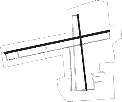
Runway info
Runway 9 / 27  | ||
| length | 1717m (5633ft) | |
| bearing | 84° / 264° | |
| width | 30m (100ft) | |
| surface | asphalt | |
| displ threshold | 0m (0ft) / 61m (200ft) | |
| Runway 18 / 36 | ||
| length | 1221m (4006ft) | |
| bearing | 177° / 357° | |
| width | 23m (75ft) | |
| surface | asphalt | |
Nearby beacons
| code | identifier | dist | bearing | frequency |
|---|---|---|---|---|
| PCW | PORT CLINTON NDB | 0.1 | 16° | 423 |
| TII | TIFFIN NDB | 29.7 | 219° | 269 |
| DJB | DRYER VOR/DME | 33.2 | 103° | 113.60 |
| RYS | GROSSE ILE (DETROIT) NDB | 37.3 | 334° | 419 |
| MFD | MANSFIELD VORTAC | 40.8 | 157° | 108.80 |
| CRL | CARLETON VOR/DME | 41.3 | 312° | 115.70 |
| TOL | TOLEDO TACAN | 42 | 275° | 112.50 |
| DT | REVUP (DETROIT) NDB | 44.1 | 317° | 388 |
| DM | SPENC (DETROIT) NDB | 44.8 | 335° | 223 |
| DXO | DETROIT VOR/DME | 47.3 | 324° | 113.40 |
| QG | WINDSOR NDB | 47.8 | 0° | 353 |
| MF | MANNS (MANSFIELD) NDB | 48.9 | 150° | 372 |
| FBC | FLAG CITY VORTAC | 52.3 | 238° | 108.20 |
| BUD | BUCKEYE (MARION) VOR | 54.7 | 192° | 109.80 |
| SVM | SALEM VORTAC | 62.6 | 321° | 114.30 |
Instrument approach procedures
| runway | airway (heading) | route (dist, bearing) |
|---|---|---|
| RW09 | SALFE (85°) | SALFE 3000ft |
| RNAV | SALFE 3000ft FASTI (6mi, 84°) 2200ft CAGSA (2mi, 84°) 1720ft KPCW (4mi, 85°) 629ft (5085mi, 117°) 990ft KUKAF (5075mi, 297°) 2500ft KUKAF (turn) | |
| RW27 | KUKAF (264°) | KUKAF 2500ft |
| RNAV | KUKAF 2500ft HOZDE (6mi, 264°) 1700ft KPCW (4mi, 264°) 628ft (5085mi, 117°) 910ft MANGS (5089mi, 297°) VASHO (4mi, 182°) 3000ft VASHO (turn) |
Disclaimer
The information on this website is not for real aviation. Use this data with the X-Plane flight simulator only! Data taken with kind consent from X-Plane 12 source code and data files. Content is subject to change without notice.