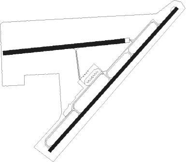
Paragould - Kirk Fld
Airport details
| Country | United States of America |
| State | Arkansas |
| Region | K4 |
| Airspace | Memphis Ctr |
| Municipality | Paragould |
| Elevation | 289ft (88m) |
| Timezone | GMT -6 |
| Coordinates | 36.06380, -90.50919 |
| Magnetic var | |
| Type | land |
| Available since | X-Plane v10.40 |
| ICAO code | KPGR |
| IATA code | PGR |
| FAA code | PGR |
Communication
| KIRK FLD CTAF/UNICOM | 122.800 |
| KIRK FLD Memphis Approach | 120.075 |
| KIRK FLD Memphis Departure | 120.075 |
Nearby Points of Interest:
Highfill-McClure House
-Linwood Mausoleum
-Beisel-Mitchell House
-Jackson-Herget House
-National Bank of Commerce Building (Paragould, Arkansas)
-Greene County Courthouse
-George Ray's Dragstrip
-Crowley's Ridge State Park-Comfort Station
-Crowley's Ridge State Park-Dining Hall
-Crowley's Ridge State Park-Bridge
-Crowley's Ridge State Park-Bathhouse
-Craighead County Road 513C Bridge
-First National Bank Building
-Knob School
-Scatterville Cemetery
-Mercantile Bank Building
-Edward L. Westbrooke Building
-Craighead County Courthouse
-Community Center No. 1
-Bell House
-Frierson House
-Berger House
-US Sen. Hattie Caraway Gravesite
-Jonesboro, Lake City & Eastern Railroad Depot
-Herman Davis State Park

Nearby beacons
| code | identifier | dist | bearing | frequency |
|---|---|---|---|---|
| JBR | JONESBORO VOR/DME | 11.9 | 203° | 108.60 |
| ARG | WALNUT RIDGE VORTAC | 21.7 | 276° | 114.50 |
| TNZ | LAWRENCE COUNTY (WALNUT RIDGE) NDB | 21.8 | 289° | 227 |
| MAW | MALDEN VORTAC | 41.3 | 51° | 111.20 |
| GQE | GILMORE VOR/DME | 43 | 178° | 113 |
Instrument approach procedures
| runway | airway (heading) | route (dist, bearing) |
|---|---|---|
| RW04 | ARG (96°) | ARG BALYA (12mi, 120°) 3000ft AYATO (5mi, 130°) 2500ft |
| RW04 | AYATO (52°) | AYATO 2500ft |
| RW04 | COXAX (27°) | COXAX AYATO (5mi, 310°) 2500ft |
| RNAV | AYATO 2500ft PAWGE (6mi, 52°) 2000ft TACOS (3mi, 52°) 980ft KPGR (2mi, 50°) 330ft (5430mi, 112°) 690ft CUBIN (5421mi, 292°) 3000ft CUBIN (turn) | |
| RW22 | CUBIN (233°) | CUBIN 3000ft |
| RW22 | DOREY (187°) | DOREY CUBIN (10mi, 130°) 3000ft |
| RW22 | HEMOR (254°) | HEMOR CUBIN (5mi, 311°) 3000ft |
| RNAV | CUBIN 3000ft EVELY (6mi, 232°) 2000ft KPGR (6mi, 233°) 325ft (5430mi, 112°) 690ft AYATO (5438mi, 292°) 2500ft AYATO (turn) |
Disclaimer
The information on this website is not for real aviation. Use this data with the X-Plane flight simulator only! Data taken with kind consent from X-Plane 12 source code and data files. Content is subject to change without notice.