Pierre - Pierre Regl
Airport details
| Country | United States of America |
| State | South Dakota |
| Region | K3 |
| Airspace | Minneapolis Ctr |
| Municipality | Pierre |
| Elevation | 1744ft (532m) |
| Timezone | GMT -6 |
| Coordinates | 44.38269, -100.28597 |
| Magnetic var | |
| Type | land |
| Available since | X-Plane v10.40 |
| ICAO code | KPIR |
| IATA code | PIR |
| FAA code | PIR |
Communication
| Pierre Regl ASOS | 119.025 |
| Pierre Regl CTAF | 122.700 |
| Pierre Regl UNICOM | 122.950 |
| Pierre Regl MINNEAPOLIS ApproachROACH | 125.100 |
| Pierre Regl MINNEAPOLIS DepartureARTURE | 125.100 |
Approach frequencies
| ILS-cat-I | RW31 | 111.9 | 18.00mi |
| 3° GS | RW31 | 111.9 | 18.00mi |
Nearby Points of Interest:
Dr. William and Elizabeth Blackburn House
-Peter Hansen House (Pierre, South Dakota)
-Crawford–Pettyjohn House
-Karcher–Sahr House
-Brink-Wegner House
-South Dakota State Capitol
-I. W. Goodner House
-John E. and Ruth Hipple House
-Farr House
-Horner–Hyde House
-Hughes County Courthouse
-Hilger Block
-Karcher Block
-Central Block (Pierre, South Dakota)
-Fort Pierre Congregational Church
-Pierre Masonic Lodge
-Freier Round Barn
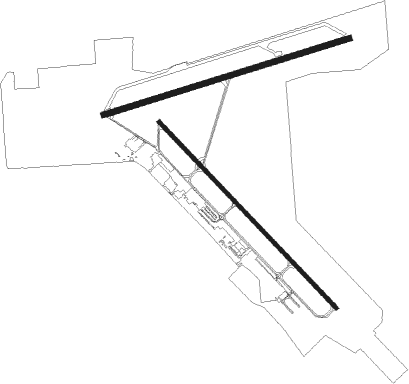
Runway info
Runway 13 / 31  | ||
| length | 2098m (6883ft) | |
| bearing | 131° / 311° | |
| width | 30m (100ft) | |
| surface | asphalt | |
| displ threshold | 5m (16ft) / 0m (0ft) | |
| blast zone | 33m (108ft) / 32m (105ft) | |
| Runway 7 / 25 | ||
| length | 2097m (6880ft) | |
| bearing | 81° / 261° | |
| width | 46m (150ft) | |
| surface | asphalt | |
Nearby beacons
| code | identifier | dist | bearing | frequency |
|---|---|---|---|---|
| PIR | PIERRE VORTAC | 5.3 | 84° | 112.50 |
Instrument approach procedures
| runway | airway (heading) | route (dist, bearing) |
|---|---|---|
| RW07 | JAGSO (317°) | JAGSO AMSIW (22mi, 284°) 4000ft HOSTR (6mi, 342°) 4000ft |
| RW07 | PIR (264°) | PIR HOSTR (17mi, 263°) 4000ft HOSTR (turn) 4000ft |
| RW07 | TUZCO (119°) | TUZCO DUCXU (23mi, 131°) 4000ft HOSTR (6mi, 162°) 4000ft |
| RNAV | HOSTR 4000ft ODREF (6mi, 81°) 3500ft KPIR (6mi, 83°) 1791ft HIWRE (12mi, 80°) 4000ft HIWRE (turn) | |
| RW13 | CABKU (73°) | CABKU COTUN (9mi, 326°) 4000ft FASIP (6mi, 59°) 4000ft |
| RW13 | GILTE (193°) | GILTE JALAB (7mi, 239°) 4000ft FASIP (6mi, 240°) 4000ft |
| RW13 | PIR (264°) | PIR FASIP (15mi, 295°) 4000ft FASIP (turn) 4000ft |
| RNAV | FASIP 4000ft HEDGO (6mi, 131°) 3500ft BATPE (3mi, 131°) 2400ft KPIR (2mi, 127°) 1783ft HOGEX (12mi, 132°) 4000ft HOGEX (turn) | |
| RW25 | ELREE (283°) | ELREE AMYOK (29mi, 285°) 4000ft HIWRE (6mi, 343°) 4000ft |
| RW25 | LIVVA (243°) | LIVVA DOKXE (25mi, 246°) 4000ft HIWRE (6mi, 163°) 4000ft |
| RW25 | PIR (264°) | PIR HIWRE (7mi, 76°) 4000ft HIWRE (turn) 4000ft |
| RNAV | HIWRE 4000ft OPPOV (6mi, 261°) 3500ft BEYAK (3mi, 261°) 2440ft KPIR (3mi, 256°) 1757ft (5845mi, 114°) 1975ft HOSTR (5857mi, 294°) 4000ft HOSTR (turn) | |
| RW31 | CABKU (73°) | CABKU JOPAK (15mi, 128°) 4000ft HOGEX (7mi, 60°) 4000ft |
| RW31 | CHANS (268°) | CHANS WESAP (25mi, 258°) 4000ft HOGEX (7mi, 240°) 4000ft |
| RW31 | HATKA (247°) | HATKA WESAP (15mi, 195°) 4000ft HOGEX (7mi, 240°) 4000ft |
| RW31 | HOGEX (312°) | HOGEX 4000ft |
| RNAV | HOGEX 4000ft BRULE (6mi, 311°) 3600ft ZUSPO (3mi, 311°) 2560ft KPIR (3mi, 314°) 1774ft (5845mi, 114°) 1920ft FASIP (5852mi, 294°) 4000ft FASIP (turn) |
Disclaimer
The information on this website is not for real aviation. Use this data with the X-Plane flight simulator only! Data taken with kind consent from X-Plane 12 source code and data files. Content is subject to change without notice.