Philadelphia - Northeast Philadelphia
Airport details
| Country | United States of America |
| State | Pennsylvania |
| Region | K6 |
| Airspace | Washington Ctr |
| Municipality | Philadelphia |
| Elevation | 121ft (37m) |
| Timezone | GMT -5 |
| Coordinates | 40.08194, -75.01058 |
| Magnetic var | |
| Type | land |
| Available since | X-Plane v10.40 |
| ICAO code | KPNE |
| IATA code | PNE |
| FAA code | PNE |
Communication
| Northeast Philadelphia ATIS | 121.150 |
| Northeast Philadelphia Clearance DEL | 127.250 |
| Northeast Philadelphia Ground Control | 121.700 |
| Northeast Philadelphia Tower | 126.900 |
| Northeast Philadelphia PHILADELPHIA Approach | 123.800 |
| Northeast Philadelphia PHILADELPHIA Departure | 123.800 |
Approach frequencies
| ILS-cat-I | RW24 | 111.1 | 18.00mi |
| 3° GS | RW24 | 111.1 | 18.00mi |
Nearby Points of Interest:
Greenbelt Knoll
-Holme Avenue Bridge
-Poquessing Creek
-Mechanicsville School
-Watson Comly School
-Glen Foerd at Torresdale
-Growden Mansion
-Fox Chase Farm
-Kennedy Crossan School
-Mary Disston School
-Ryerss Mansion
-Tacony Music Hall
-Bryn Athyn Historic District
-Fetter's Mill
-Fetter's Mill Village Historic District
-Rowland House
-Cairnwood
-George K. Heller School
-St. Stephen's Episcopal Church
-Belmont
-Benjamin Franklin Academics Plus School
-Bristol College
-Warren G. Harding Middle School
-David Wilmot School
-Friends Hospital
Runway info
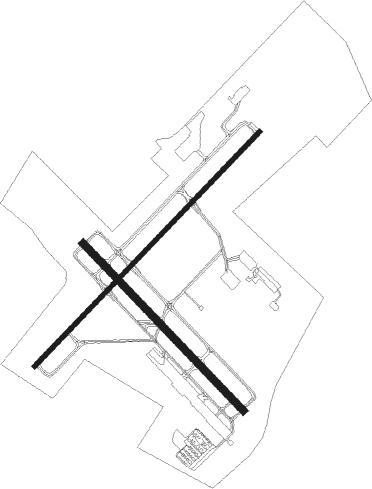
Runway 6 / 24  | ||
| length | 2136m (7008ft) | |
| bearing | 56° / 236° | |
| width | 30m (98ft) | |
| surface | asphalt | |
| blast zone | 0m (0ft) / 6m (20ft) | |
| Runway 15 / 33 | ||
| length | 1524m (5000ft) | |
| bearing | 133° / 313° | |
| width | 46m (150ft) | |
| surface | asphalt | |
Nearby beacons
| code | identifier | dist | bearing | frequency |
|---|---|---|---|---|
| ARD | YARDLEY VOR/DME | 11.3 | 31° | 108.20 |
| ING | AMBLER NDB | 12.8 | 279° | 275 |
| GXU | MC GUIRE (WRIGHTSTOWN) VORTAC | 19.5 | 100° | 110.60 |
| RBV | ROBBINSVILLE VORTAC | 24.7 | 77° | 113.80 |
| PTW | POTTSTOWN VORTAC | 26.6 | 284° | 116.50 |
| OOD | WOODSTOWN VORTAC | 29.9 | 213° | 112.80 |
| NEL | LAKEHURST TACAN | 30.3 | 94° | 111.80 |
| CYN | COYLE VORTAC | 31 | 115° | 113.40 |
| NEL | LAKEHURST NDB | 31.1 | 93° | 396 |
| MXE | MODENA VORTAC | 31.9 | 256° | 113.20 |
| SBJ | SOLBERG VOR/DME | 32.5 | 28° | 112.90 |
| VCN | CEDAR LAKE (MILLVILLE) VOR/DME | 32.7 | 175° | 115.20 |
| DQO | DUPONT (WILMINGTON) VORTAC | 36.6 | 236° | 114 |
| RNB | RAINBOW (MILLVILLE) NDB | 40.2 | 191° | 363 |
| IL | HADIN (WILMINGTON) NDB | 40.9 | 230° | 248 |
| COL | COLTS NECK VOR/DME | 41.3 | 75° | 115.40 |
| ACY | ATLANTIC CITY VORTAC | 42.6 | 145° | 108.60 |
| ETX | EAST TEXAS VOR/DME | 43 | 307° | 110.20 |
| FJC | ALLENTOWN VORTAC | 43.7 | 325° | 117.50 |
| BWZ | BROADWAY (SCHOOLEY'S MT) VOR/DME | 43.8 | 15° | 114.20 |
| CAT | CHATHAM NDB | 47.6 | 41° | 254 |
| STW | STILLWATER VOR/DME | 55.2 | 9° | 109.60 |
| ENO | SMYRNA (KENTON) VORTAC | 56.1 | 211° | 111.40 |
| MM | MOREE (MORRISTOWN) NDB | 57 | 40° | 392 |
| TE | TORBY (TETERBORO) NDB | 59.1 | 51° | 214 |
| SIE | SEA ISLE VORTAC | 60 | 168° | 114.80 |
| DOV | DOVER TACAN | 60.8 | 206° | 110 |
| SAX | SPARTA VORTAC | 62.9 | 26° | 115.70 |
| TEB | TETERBORO VOR/DME | 63.2 | 51° | 108.40 |
Departure and arrival routes
| Transition altitude | 18000ft |
| Transition level | 18000ft |
| STAR starting points | distance | inbound heading | |
|---|---|---|---|
| ALL | |||
| PAATS3 | 56.3 | 39° | |
| BUNTS2 | 95.3 | 96° | |
| JIIMS3, VCN9 | 32.7 | 355° | |
Instrument approach procedures
| runway | airway (heading) | route (dist, bearing) |
|---|---|---|
| RW15 | MAZIE (158°) | MAZIE KEHSO (7mi, 202°) 2000ft |
| RW15 | PTW (104°) | PTW COREM (14mi, 98°) 2000ft KEHSO (5mi, 75°) 2000ft |
| RNAV | KEHSO 2000ft PACKS (6mi, 133°) 1400ft LEBBI (2mi, 133°) 820ft KPNE (2mi, 131°) 159ft (4720mi, 118°) 520ft EPECU (4712mi, 298°) 2000ft EPECU (turn) | |
| RW24 | ARD (211°) | ARD FLITS (5mi, 110°) 2100ft FLITS (turn) 2100ft |
| RW24 | RBV (257°) | RBV FLITS (15mi, 273°) 2100ft |
| RNAV | FLITS 2100ft BORDA (6mi, 236°) 2000ft KPNE (6mi, 235°) 167ft (4720mi, 118°) 900ft ARD (4717mi, 298°) 3000ft ARD (turn) | |
| RW33 | CYN (295°) | CYN KABKE (17mi, 297°) 2000ft EPECU (6mi, 255°) 2000ft |
| RW33 | OOD (33°) | OOD FOSIT (23mi, 58°) 2000ft EPECU (5mi, 38°) 2000ft |
| RNAV | EPECU 2000ft FARES (6mi, 313°) 1400ft ASUSE (2mi, 313°) 800ft KPNE (3mi, 315°) 147ft (4720mi, 118°) 380ft PACKS (4723mi, 298°) MAZIE (11mi, 348°) 2500ft MAZIE (turn) |
Holding patterns
| STAR name | hold at | type | turn | heading* | altitude | leg | speed limit |
|---|---|---|---|---|---|---|---|
| BUNTS2 | BUNTS | VHF | left | 284 (104)° | 6001ft - 14000ft | DME 4.0mi | 210 |
| BUNTS2 | MIROY | VHF | right | 276 (96)° | 1.5min timed | ICAO rules | |
| JIIMS3 | JIIMS | VHF | left | 228 (48)° | 6001ft - 14000ft | DME 4.0mi | 210 |
| PAATS3 | BUKYY | VHF | right | 248 (68)° | DME 10.0mi | ICAO rules | |
| PAATS3 | GARED | VHF | left | 226 (46)° | 1.0min timed | ICAO rules | |
| PAATS3 | PAATS | VHF | left | 231 (51)° | 6001ft - 14000ft | DME 5.0mi | 210 |
| VCN9 | VCN | NDB | left | 226 (46)° | 6001ft - 14000ft | 1.0min timed | 210 |
| *) magnetic outbound (inbound) holding course | |||||||
Disclaimer
The information on this website is not for real aviation. Use this data with the X-Plane flight simulator only! Data taken with kind consent from X-Plane 12 source code and data files. Content is subject to change without notice.