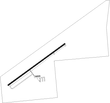
Pontiac - Pontiac Muni
Airport details
| Country | United States of America |
| State | Illinois |
| Region | K5 |
| Airspace | Chicago Ctr |
| Municipality | Pontiac |
| Elevation | 666ft (203m) |
| Timezone | GMT -6 |
| Coordinates | 40.92445, -88.62395 |
| Magnetic var | |
| Type | land |
| Available since | X-Plane v10.40 |
| ICAO code | KPNT |
| IATA code | n/a |
| FAA code | PNT |
Communication
| Pontiac Muni AWOS 3 | 119.675 |
| Pontiac Muni CTAF/UNICOM | 122.800 |
Nearby Points of Interest:
Pontiac City Hall and Fire Station
-Jones House
-Livingston County Courthouse
-Raymond Schulz Round Barn
-Illinois State Police Office
-Standard Oil Gasoline Station
-Thomas A. Beach House
-Matthew T. Scott House
-Fairbury City Hall
-John R. Oughton House
-Dwight depot (Chicago and Alton Railroad)
-Silas Williams House
-Streator Public Library
-Ruffin Drew Fletcher House
-John Patton Log Cabin
-David Hyatt Van Dolah House
-El Paso freight station
-El Paso Public Library
-Benson Water Tower
-Armour's Warehouse
-Marseilles Hydro Plant
-Chicago, Rock Island and Pacific Railroad Depot
-Marseilles Lock and Dam Historic District
-Duncan Manor
-Hubbard House (Illinois)
Runway info
| Runway 6 / 24 | ||
| length | 1525m (5003ft) | |
| bearing | 65° / 245° | |
| width | 23m (75ft) | |
| surface | asphalt | |
Nearby beacons
| code | identifier | dist | bearing | frequency |
|---|---|---|---|---|
| PNT | PONTIAC VOR/DME | 7.9 | 227° | 109.60 |
| DTG | DWIGHT NDB | 15.1 | 42° | 344 |
| LH | EGROW (BLOOMINGTON-NORMAL) NDB | 24.6 | 215° | 334 |
| RBS | ROBERTS VOR/DME | 29.3 | 127° | 116.80 |
| BMI | BLOOMINGTON VOR/DME | 30 | 215° | 108.20 |
| IK | LUKOW (KANKAKEE) NDB | 33.1 | 83° | 272 |
| IKK | DME | 36.2 | 79° | 111.60 |
| JOT | JOLIET VOR/DME | 39.8 | 26° | 112.30 |
| EON | PEOTONE VORTAC | 43 | 67° | 113.20 |
| BDF | BRADFORD VORTAC | 45.8 | 284° | 114.70 |
| PI | TUNGG (PEORIA) NDB | 48 | 252° | 356 |
| CMI | CHAMPAIGN VORTAC | 55.7 | 159° | 110 |
| AAA | ABRAHAM (LINCOLN) NDB | 56.2 | 223° | 329 |
| DPA | DUPAGE (CHICAGO) VOR/DME | 59.3 | 16° | 108.40 |
| CM | VEALS (CHAMPAIGN/URBANA) NDB | 60.9 | 155° | 407 |
| MX | KEDZI (CHICAGO) NDB | 64.6 | 49° | 248 |
Instrument approach procedures
| runway | airway (heading) | route (dist, bearing) |
|---|---|---|
| RW06 | BUCLA (65°) | BUCLA 3000ft |
| RW06 | HUMUL (72°) | HUMUL BUCLA (10mi, 79°) 3000ft |
| RW06 | RBS (307°) | RBS METSE (30mi, 285°) 3000ft BUCLA (5mi, 321°) 3000ft |
| RW06 | SMARS (131°) | SMARS LARTE (14mi, 189°) 3000ft BUCLA (5mi, 141°) 3000ft |
| RNAV | BUCLA 3000ft CEGRA (6mi, 65°) 2300ft KPNT (5mi, 65°) 689ft (5343mi, 115°) 1040ft KEJDO (5333mi, 295°) 3000ft KEJDO (turn) | |
| RW24 | MOTIF (202°) | MOTIF USUTE (8mi, 164°) 3000ft KEJDO (5mi, 141°) 3000ft |
| RW24 | PNT (47°) | PNT KEJDO (19mi, 58°) 3000ft KEJDO (turn) 3000ft |
| RW24 | RBS (307°) | RBS ILEBY (24mi, 334°) 3000ft KEJDO (5mi, 321°) 3000ft |
| RNAV | KEJDO 3000ft VONFY (6mi, 245°) 2300ft KPNT (5mi, 245°) 701ft BUCLA (12mi, 245°) 3000ft BUCLA (turn) |
Disclaimer
The information on this website is not for real aviation. Use this data with the X-Plane flight simulator only! Data taken with kind consent from X-Plane 12 source code and data files. Content is subject to change without notice.
