Paris - Cox Field
Airport details
| Country | United States of America |
| State | Texas |
| Region | K4 |
| Airspace | Ft Worth Ctr |
| Municipality | Paris |
| Elevation | 546ft (166m) |
| Timezone | GMT -5 |
| Coordinates | 33.63453, -95.45655 |
| Magnetic var | |
| Type | land |
| Available since | X-Plane v10.40 |
| ICAO code | KPRX |
| IATA code | PRX |
| FAA code | PRX |
Communication
| Cox Field AWOS 3 | 119.675 |
| Cox Field CTAF/UNICOM | 122.975 |
Nearby Points of Interest:
First United Methodist Church
-Sam Bell Maxey House
-First Church of Christ, Scientist
-First Presbyterian Church
-Hugo Historic District
-Hopkins County Courthouse
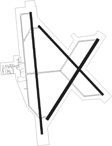
Runway info
Runway 17 / 35  | ||
| length | 1834m (6017ft) | |
| bearing | 179° / 359° | |
| width | 30m (100ft) | |
| surface | asphalt | |
| Runway 3 / 21 | ||
| length | 1411m (4629ft) | |
| bearing | 42° / 222° | |
| width | 46m (150ft) | |
| surface | concrete | |
| Runway 14 / 32 | ||
| length | 1411m (4629ft) | |
| bearing | 136° / 316° | |
| width | 30m (100ft) | |
| surface | concrete | |
Nearby beacons
| code | identifier | dist | bearing | frequency |
|---|---|---|---|---|
| PRX | PARIS VOR/DME | 5.5 | 175° | 113.60 |
| SLR | SULPHUR SPRINGS VOR/DME | 26.5 | 191° | 109 |
| BYP | BONHAM VORTAC | 39.3 | 263° | 114.60 |
| GV | MAJOR (GREENVILLE) NDB | 41.8 | 232° | 201 |
| UIM | DME | 45.5 | 173° | 114 |
| MJF | ARVILLA (GREENVILLE) TACAN | 45.6 | 227° | 109.60 |
| URH | (DURANT) DME | 50.2 | 288° | 114.30 |
Instrument approach procedures
| runway | airway (heading) | route (dist, bearing) |
|---|---|---|
| RW17 | NUKIC (152°) | NUKIC 2200ft PUYOS (5mi, 89°) 2200ft |
| RW17 | PUYOS (180°) | PUYOS 2200ft |
| RW17 | ZUPOM (207°) | ZUPOM 2200ft PUYOS (5mi, 269°) 2200ft |
| RNAV | PUYOS 2200ft KEYEP (6mi, 179°) 2200ft KPRX (6mi, 180°) 581ft (5678mi, 109°) 948ft CUKBO (5678mi, 289°) 2200ft CUKBO (turn) | |
| RW35 | CUKBO (358°) | CUKBO 2200ft |
| RW35 | HOLOB (26°) | HOLOB 2200ft CUKBO (5mi, 89°) 2200ft |
| RW35 | OYUGA (331°) | OYUGA 2200ft CUKBO (5mi, 269°) 2200ft |
| RNAV | CUKBO 2200ft JAVMU (6mi, 359°) 2200ft KPRX (5mi, 358°) 579ft (5678mi, 109°) 948ft PUYOS (5677mi, 290°) 2200ft PUYOS (turn) |
Disclaimer
The information on this website is not for real aviation. Use this data with the X-Plane flight simulator only! Data taken with kind consent from X-Plane 12 source code and data files. Content is subject to change without notice.