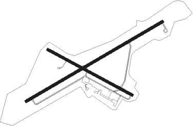
Pittsfield - Pittsfield Muni
Airport details
| Country | United States of America |
| State | Massachusetts |
| Region | K6 |
| Airspace | Boston Ctr |
| Municipality | Pittsfield |
| Elevation | 1190ft (363m) |
| Timezone | GMT -5 |
| Coordinates | 42.42762, -73.29084 |
| Magnetic var | |
| Type | land |
| Available since | X-Plane v10.40 |
| ICAO code | KPSF |
| IATA code | n/a |
| FAA code | PSF |
Communication
| Pittsfield Muni ASOS | 135.375 |
| Pittsfield Muni CTAF/UNICOM | 122.700 |
| Pittsfield Muni ALBANY Approach/Departure | 132.825 |
Approach frequencies
| LOC | RW26 | 108.3 | 18.00mi |
Nearby Points of Interest:
South Mountain Concert Hall
-Morewood School
-Charles Whittlesey Power House
-Eaton, Crane & Pike Company Factory
-Nichols-Sterner House
-Berkshire Life Insurance Company Building
-Old Town Hall
-Old Central Fire Station
-Wollison-Shipton Building
-Samuel Harrison House
-William Russell Allen House
-Providence Court
-Upper North Street Commercial District
-Old Central High School
-Northeast School
-A. H. Rice Silk Mill
-Pilgrim Memorial Church and Parish House
-Springside Park (Pittsfield, Massachusetts)
-Goodwood
-Kenmore
-Shaker Farm
-Lenox Academy
-Lenox High School
-Ventfort Hall Mansion and Gilded Age Museum
-Frelinghuysen Morris House and Studio
Nearby beacons
| code | identifier | dist | bearing | frequency |
|---|---|---|---|---|
| CTR | CHESTER VOR/DME | 17.2 | 112° | 115.10 |
| PFH | PHILMONT (HUDSON) NDB | 21.8 | 248° | 272 |
| ALB | ALBANY VORTAC | 29.6 | 302° | 115.30 |
| BAF | BARNES (WESTFIELD/SPRINGF VORTAC | 30.1 | 115° | 113 |
| AL | HAWKY (ALBANY) NDB | 32.7 | 307° | 219 |
| CAM | CAMBRIDGE VOR/DME | 34.1 | 355° | 115 |
| CEF | WESTOVER(SPRINGFIELD/CHIC TACAN | 36.6 | 107° | 114 |
| HEU | HUNTER (SCHENECTADY) NDB | 38.2 | 304° | 356 |
| PWL | PAWLING (POUGHKEEPSIE) VOR/DME | 41.8 | 205° | 114.30 |
| EEN | DME | 49.3 | 70° | 109.40 |
| GF | GANSE (GLENS FALLS) NDB | 51.5 | 339° | 209 |
| IGN | KINGSTON VOR/DME | 51.5 | 215° | 117.60 |
| HFD | HARTFORD VOR/DME | 57.7 | 137° | 114.90 |
| SKU | STANWYCK (NEWBURGH) NDB | 63.6 | 220° | 261 |
| CNH | CLAREMONT NDB | 69.5 | 44° | 233 |
| SW | NEELY (NEWBURGH) NDB | 70.3 | 225° | 335 |
Instrument approach procedures
| runway | airway (heading) | route (dist, bearing) |
|---|---|---|
| RW08 | BOWAN (36°) | BOWAN OLOKE (14mi, 357°) 3500ft |
| RW08 | CIRRU (99°) | CIRRU OLOKE (12mi, 134°) 3500ft |
| RW08 | OLOKE (70°) | OLOKE 3500ft |
| RNAV | OLOKE 3500ft RICEC (6mi, 70°) 3000ft OXUTY (2mi, 70°) 2260ft KPSF (4mi, 71°) 1243ft (4669mi, 120°) 1475ft AZBAF (4659mi, 300°) 4000ft AZBAF (turn) | |
| RW26 | CAM (175°) | CAM WIROR (24mi, 147°) 5700ft AZBAF (7mi, 147°) 4000ft |
| RW26 | CTR (292°) | CTR GIVHE (7mi, 352°) 4000ft AZBAF (7mi, 327°) 4000ft |
| RNAV | AZBAF 4000ft HIMUT (6mi, 250°) 3200ft JUGES (3mi, 250°) 2400ft KPSF (4mi, 250°) 1182ft (4669mi, 120°) 2800ft HIDAL (4676mi, 300°) 4000ft HIDAL (turn) |
Disclaimer
The information on this website is not for real aviation. Use this data with the X-Plane flight simulator only! Data taken with kind consent from X-Plane 12 source code and data files. Content is subject to change without notice.

