Palestine - Palestine Municipal
Airport details
| Country | United States of America |
| State | Texas |
| Region | K4 |
| Airspace | Ft Worth Ctr |
| Municipality | Palestine |
| Elevation | 421ft (128m) |
| Timezone | GMT -6 |
| Coordinates | 31.77969, -95.70631 |
| Magnetic var | |
| Type | land |
| Available since | X-Plane v10.40 |
| ICAO code | KPSN |
| IATA code | PSN |
| FAA code | PSN |
Communication
Nearby Points of Interest:
Sacred Heart Catholic Church and School
-First Presbyterian Church
-Anderson County Courthouse
-Texas and Pacific 610
-Anderson Camp Ground
-Faulk and Gauntt Building
-First United Methodist Church
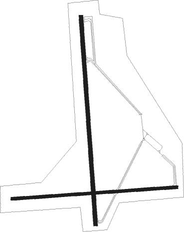
Runway info
Runway 9 / 27  | ||
| length | 1297m (4255ft) | |
| bearing | 90° / 270° | |
| width | 23m (75ft) | |
| surface | asphalt | |
| Runway 18 / 36 | ||
| length | 1627m (5338ft) | |
| bearing | 181° / 1° | |
| width | 30m (100ft) | |
| surface | asphalt | |
Nearby beacons
| code | identifier | dist | bearing | frequency |
|---|---|---|---|---|
| FZT | FRANKSTON VOR/DME | 19.8 | 31° | 111.40 |
| CSZ | CROSSROADS NDB | 21.3 | 318° | 215 |
| CQY | CEDAR CREEK VORTAC | 35.6 | 308° | 114.80 |
| TYR | TYLER VOR/DME | 37.8 | 28° | 114.20 |
| CRS | CORSICANA NDB | 38.1 | 290° | 396 |
| CGQ | POWELL (CORSICANA) NDB | 40.4 | 292° | 344 |
| LOA | LEONA VORTAC | 41.5 | 202° | 110.80 |
| LXY | MEXIA NDB | 42 | 260° | 329 |
| GNL | GROESBECK (MEXIA) VOR/DME | 44.6 | 257° | 108.80 |
| OC | NADOS (NACOGDOCHES) NDB | 53.4 | 107° | 253 |
| LF | FLUFY (LUFKIN) NDB | 56.3 | 122° | 350 |
| ABG | AMBASSADOR (BIG SANDY) NDB | 57 | 36° | 404 |
| GG | VEELS (LONGVIEW) NDB | 61.5 | 53° | 410 |
| GGG | GREGG CO. (LONGVIEW) VORTAC | 61.8 | 56° | 112.90 |
| LFK | LUFKIN VORTAC | 62.7 | 122° | 112.10 |
Instrument approach procedures
| runway | airway (heading) | route (dist, bearing) |
|---|---|---|
| RW18 | CERBU (181°) | CERBU 2500ft |
| RW18 | DUCAL (206°) | DUCAL 2500ft CERBU (5mi, 270°) 2500ft |
| RW18 | HIBIX (155°) | HIBIX 2500ft CERBU (5mi, 90°) 2500ft |
| RNAV | CERBU 2500ft SIRRO (6mi, 181°) 2200ft KPSN (6mi, 181°) 453ft (5696mi, 108°) 1040ft FERES (5697mi, 288°) 3000ft FERES (turn) | |
| RW36 | AVUYA (28°) | AVUYA 3000ft FERES (5mi, 90°) 3000ft |
| RW36 | ECEBA (333°) | ECEBA 3000ft FERES (5mi, 270°) 3000ft |
| RW36 | FERES (1°) | FERES 3000ft |
| RNAV | FERES 3000ft HEPEX (6mi, 1°) 2000ft KPSN (5mi, 1°) 450ft (5696mi, 108°) 820ft CERBU (5696mi, 288°) 2500ft CERBU (turn) |
Disclaimer
The information on this website is not for real aviation. Use this data with the X-Plane flight simulator only! Data taken with kind consent from X-Plane 12 source code and data files. Content is subject to change without notice.