Platteville - Platteville Muni
Airport details
| Country | United States of America |
| State | Wisconsin |
| Region | K5 |
| Airspace | Chicago Ctr |
| Municipality | Town of Platteville |
| Elevation | 1022ft (312m) |
| Timezone | GMT -6 |
| Coordinates | 42.68936, -90.44439 |
| Magnetic var | |
| Type | land |
| Available since | X-Plane v10.40 |
| ICAO code | KPVB |
| IATA code | n/a |
| FAA code | PVB |
Communication
| Platteville Muni CTAF/UNICOM | 122.700 |
Nearby Points of Interest:
Bayley Avenue Historic District
-Ullrich Hall
-Beebe House
-Mitchell-Rountree House
-Hazel Green Town Hall
-Water Street Commercial Historic District
-Gratiot House
-Eagle Point Park
-Four Mounds Estate Historic District
-Charles Wenner House
-Lafayette County Courthouse
-Saint Mary's Catholic Church
-Hollenfelz House
-Dubuque Star Brewery
-Upper Iowa Street Historic District
-Ziepprecht Block
-Dubuque Millworking Historic District
-Dubuque City Hall
-Henry N. Frentess Farmstead
-Mottley Family Farmstead
-Dubuque County Courthouse
-Andrew-Ryan House
-Dubuque YMCA Building
-Upper Main Street Historic District
-Security Building
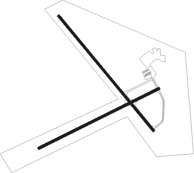
Runway info
Runway 15 / 33  | ||
| length | 1220m (4003ft) | |
| bearing | 136° / 316° | |
| width | 23m (75ft) | |
| surface | asphalt | |
| Runway 7 / 25 | ||
| length | 1098m (3602ft) | |
| bearing | 74° / 254° | |
| width | 23m (75ft) | |
| surface | asphalt | |
Nearby beacons
| code | identifier | dist | bearing | frequency |
|---|---|---|---|---|
| DBQ | DUBUQUE VORTAC | 20.8 | 223° | 115.80 |
| DB | ZILOM (DUBUQUE) NDB | 23 | 203° | 341 |
| LNR | ROCK DME | 38.8 | 27° | 116.05 |
| FN | HILLZ (CLINTON) NDB | 56.3 | 177° | 517 |
| CVA | DAVENPORT VORTAC | 58.9 | 182° | 113.80 |
| PLL | POLO VOR/DME | 59.6 | 128° | 111.20 |
| DLL | DELLS (BARABOO) VORTAC | 59.7 | 38° | 117 |
Instrument approach procedures
| runway | airway (heading) | route (dist, bearing) |
|---|---|---|
| RW07 | DBQ (43°) | DBQ TIREW (13mi, 1°) 3000ft |
| RW07 | SWAGG (112°) | SWAGG TIREW (15mi, 151°) 3000ft |
| RNAV | TIREW 3000ft SESPY (6mi, 73°) 3000ft KPVB (6mi, 73°) 1039ft (5425mi, 115°) 1283ft CERIG (5413mi, 295°) 3000ft CERIG (turn) | |
| RW15 | BAULK (271°) | BAULK KAVLY (19mi, 305°) 3000ft CEWUF (5mi, 243°) 3000ft |
| RW15 | CEWUF (137°) | CEWUF 3000ft |
| RW15 | ISINY (130°) | ISINY CEWUF (7mi, 118°) 3000ft |
| RW15 | SWAGG (112°) | SWAGG JALUG (6mi, 104°) 3000ft CEWUF (5mi, 62°) 3000ft |
| RNAV | CEWUF 3000ft TANCI (6mi, 136°) 3000ft KPVB (6mi, 137°) 1063ft ZAWDI (11mi, 136°) 3000ft ZAWDI (turn) | |
| RW25 | CERIG (254°) | CERIG 6000ft CERIG (turn) 3000ft |
| RW25 | DALEY (252°) | DALEY CERIG (19mi, 250°) 3000ft |
| RW25 | ISINY (130°) | ISINY IDUBE (23mi, 99°) 3000ft CERIG (5mi, 152°) 3000ft |
| RW25 | MADDY (286°) | MADDY SALDR (20mi, 298°) 3000ft CERIG (5mi, 332°) 3000ft |
| RNAV | CERIG 3000ft FEBEK (6mi, 254°) 3000ft OBOTE (3mi, 254°) 1900ft KPVB (3mi, 255°) 1062ft (5425mi, 115°) 1425ft CERIG (5413mi, 295°) 3000ft CERIG (turn) | |
| RW33 | BAULK (271°) | BAULK NOKLY (6mi, 189°) 3000ft ZAWDI (5mi, 243°) 3000ft |
| RW33 | DBQ (43°) | DBQ EYVAC (15mi, 74°) 3000ft ZAWDI (5mi, 63°) 3000ft |
| RW33 | ILOBE (316°) | ILOBE ZAWDI (7mi, 316°) 3000ft |
| RW33 | ZAWDI (316°) | ZAWDI 3000ft |
| RNAV | ZAWDI 3000ft HAKAX (6mi, 316°) 2500ft KPVB (5mi, 315°) 1062ft CEWUF (12mi, 317°) 3000ft CEWUF (turn) |
Disclaimer
The information on this website is not for real aviation. Use this data with the X-Plane flight simulator only! Data taken with kind consent from X-Plane 12 source code and data files. Content is subject to change without notice.