Portland - Portland Intl Jetport
Airport details
| Country | United States of America |
| State | Maine |
| Region | K6 |
| Airspace | Boston Ctr |
| Municipality | South Portland |
| Elevation | 77ft (23m) |
| Timezone | GMT -5 |
| Coordinates | 43.64565, -70.30862 |
| Magnetic var | |
| Type | land |
| Available since | X-Plane v10.40 |
| ICAO code | KPWM |
| IATA code | PWM |
| FAA code | PWM |
Communication
| Portland Intl Jetport ATIS | 119.050 |
| Portland Intl Jetport UNICOM | 123.500 |
| Portland Intl Jetport CTAF | 120.900 |
| Portland Intl Jetport UNICOM | 122.950 |
| Portland Intl Jetport Ground Control | 121.900 |
| Portland Intl Jetport Tower | 120.900 |
| Portland Intl Jetport Approach/Departure | 125.500 |
| Portland Intl Jetport Approach/Departure | 132.400 |
| Portland Intl Jetport Approach/Departure | 119.750 |
Approach frequencies
| ILS-cat-III | RW11 | 109.9 | 18.00mi |
| ILS-cat-II | RW29 | 109.9 | 18.00mi |
| 3° GS | RW29 | 109.9 | 18.00mi |
| 3° GS | RW11 | 109.9 | 18.00mi |
Nearby Points of Interest:
State Reform School Historic District
-Tate House
-Leonard Bond Chapman House
-Maine Central Railroad General Office Building
-Adam P. Leighton House
-The Gothic House
-John Calvin Stevens House
-Nathan Clifford School
-Harrison B. Brown House
-Western Promenade Historic District
-Maine Eye and Ear Infirmary
-A.B. Butler House
-Deering Oaks
-Sparrow House
-Thomas Brackett Reed House
-Deering Street Historic District
-Portland Club
-Griffin House
-Hamblen Development Historic District
-Spring Street Historic District
-Loring House Apartments
-Park Street Row
-Charles Q. Clapp Block
-McLellan-Sweat Mansion
-Joseph Holt Ingraham House
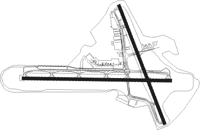
Runway info
Runway 11 / 29  | ||
| length | 2189m (7182ft) | |
| bearing | 94° / 274° | |
| width | 46m (150ft) | |
| surface | asphalt | |
| blast zone | 61m (200ft) / 61m (200ft) | |
| Runway 18 / 36 | ||
| length | 1868m (6129ft) | |
| bearing | 157° / 337° | |
| width | 46m (150ft) | |
| surface | asphalt | |
| displ threshold | 137m (449ft) / 152m (499ft) | |
Nearby beacons
| code | identifier | dist | bearing | frequency |
|---|---|---|---|---|
| ENE | KENNEBUNK VOR/DME | 18.7 | 234° | 117.10 |
| LE | LEWIE (AUBURN-LEWISTON) NDB | 19 | 355° | 240 |
| SF | SANFD (SANFORD) NDB | 29.5 | 239° | 349 |
| ESG | ROLLINS (ROLLINSFORD) NDB | 34.1 | 231° | 260 |
| PSM | (PORTSMOUTH) DME | 40.7 | 223° | 116.50 |
| AUG | AUGUSTA VOR/DME | 46.1 | 37° | 114.95 |
| AU | DUNNS (AUGUSTA) NDB | 49.8 | 30° | 366 |
| LWM | DME | 64.3 | 221° | 112.50 |
| BML | DME | 70.3 | 318° | 116.55 |
Departure and arrival routes
| Transition altitude | 18000ft |
| Transition level | 18000ft |
| SID end points | distance | outbound heading | |
|---|---|---|---|
| RW11 | |||
| NUBLE4 | 147mi | 234° | |
| HSKEL3 | 259mi | 265° | |
| PWM6 | 69mi | 300° | |
| RW18 | |||
| PWM6 | 69mi | 300° | |
| RW29 | |||
| NUBLE4 | 147mi | 234° | |
| HSKEL3 | 259mi | 265° | |
| PWM6 | 69mi | 300° | |
| RW36 | |||
| PWM6 | 69mi | 300° | |
| STAR starting points | distance | inbound heading | |
|---|---|---|---|
| RW11 | |||
| CDOGG4 | 24.8 | 79° | |
| SCOGS3 | 24.0 | 348° | |
| RW29 | |||
| CDOGG4 | 24.8 | 79° | |
| SCOGS3 | 24.0 | 348° | |
Instrument approach procedures
| runway | airway (heading) | route (dist, bearing) |
|---|---|---|
| RW11 | BUXTO (94°) | BUXTO 2300ft |
| RW11 | ENE (54°) | ENE IPKAH (11mi, 0°) 2600ft BUXTO (4mi, 60°) 2300ft |
| RW11 | LIMER (94°) | LIMER AIMME (11mi, 94°) 3500ft BUXTO (6mi, 94°) 2300ft |
| RW11 | SERPA (119°) | SERPA DALYB (8mi, 153°) 3500ft BUXTO (4mi, 131°) 2300ft |
| RNAV | BUXTO 2300ft MAINA (4mi, 94°) 1800ft FINUS (3mi, 94°) 700ft KPWM (3mi, 93°) 127ft (4558mi, 122°) 276ft SAPPE (4547mi, 302°) 3000ft SAPPE (turn) 3000ft | |
| RW18 | BRNNS (235°) | BRNNS TOBKE (12mi, 266°) 3100ft JANOB (8mi, 258°) 3100ft |
| RW18 | JUVIN (336°) | JUVIN JANOB (25mi, 337°) 3100ft JANOB (turn) 3100ft |
| RW18 | LABEL (107°) | LABEL JANOB (17mi, 81°) 3100ft |
| RW18 | NOLLI (199°) | NOLLI JANOB (20mi, 220°) 3100ft |
| RNAV | JANOB 3100ft ZIRNO (7mi, 157°) 1800ft KPWM (6mi, 160°) 98ft (4558mi, 122°) 300ft JUVIN (4551mi, 302°) 3100ft JUVIN (turn) 3100ft | |
| RW29 | AUG (217°) | AUG TAATE (39mi, 195°) 3000ft SAPPE (5mi, 238°) 3000ft |
| RW29 | ENE (54°) | ENE SAPPE (27mi, 70°) 3000ft SAPPE (turn) 3000ft |
| RW29 | MESHL (336°) | MESHL SLAMZ (17mi, 38°) 3000ft SAPPE (5mi, 311°) 3000ft |
| RNAV | SAPPE 3000ft PEATT (6mi, 274°) 1700ft KPWM (5mi, 274°) 92ft (4558mi, 122°) 256ft BUXTO (4567mi, 302°) 3000ft BUXTO (turn) 3000ft | |
| RW36 | BRNNS (235°) | BRNNS BAILI (13mi, 171°) 3000ft HUSAT (14mi, 214°) 2500ft JUVIN (8mi, 258°) 2500ft |
| RW36 | ENE (54°) | ENE TOSPE (10mi, 94°) 2500ft JUVIN (8mi, 78°) 2500ft |
| RW36 | JANOB (159°) | JANOB JUVIN (25mi, 157°) 2500ft JUVIN (turn) 2500ft |
| RNAV | JUVIN 2500ft ZIRSO (7mi, 338°) 1800ft BEYDA (3mi, 337°) 700ft KPWM (2mi, 331°) 100ft (4558mi, 122°) 460ft JANOB (4564mi, 302°) 3100ft JANOB (turn) 3100ft |
Disclaimer
The information on this website is not for real aviation. Use this data with the X-Plane flight simulator only! Data taken with kind consent from X-Plane 12 source code and data files. Content is subject to change without notice.