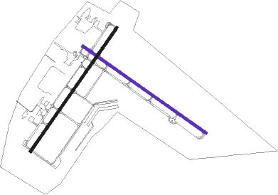
Plymouth - Plymouth Muni
Airport details
| Country | United States of America |
| State | Massachusetts |
| Region | K6 |
| Airspace | Boston Ctr |
| Municipality | Plymouth |
| Elevation | 145ft (44m) |
| Timezone | GMT -5 |
| Coordinates | 41.90903, -70.72878 |
| Magnetic var | |
| Type | land |
| Available since | X-Plane v10.40 |
| ICAO code | KPYM |
| IATA code | PYM |
| FAA code | PYM |
Communication
| Plymouth Muni ASOS | 135.625 |
| Plymouth Muni CTAF/UNICOM | 123.000 |
| Plymouth Muni CAPE Approach/Departure | 118.200 |
Approach frequencies
| ILS-cat-I | RW06 | 109.35 | 18.00mi |
| 3° GS | RW06 | 109.35 | 18.00mi |
Nearby Points of Interest:
Hillside
-Bartlett-Russell-Hedge House
-Plymouth Post Office Building
-Plymouth Antiquarian House
-Cole's Hill
-Sgt. William Harlow Family Homestead
-Plympton Village Historic District
-Bradford House
-Kingston Center Historic District
-Frederic C. Adams Public Library
-Clifford-Warren House
-Alexander Standish House
-Pinewoods Camp
-Middleborough Waterworks
-Tarkiln School
-Old Town Hall Historic District
-East Rochester Church and Cemetery Historic District
-Capt. Gershom Bradford House
-Capt. Gamaliel Bradford House
-Captain Daniel Bradford House
-Peter Pierce Store
-United States Post Office–Middleborough Main
-Leonard, Shaw & Dean Shoe Factory
-Middleborough Center Historic District
-John and Priscilla Alden Family Sites
Nearby beacons
| code | identifier | dist | bearing | frequency |
|---|---|---|---|---|
| FMH | OTIS (FALMOUTH) TACAN | 17.8 | 139° | 115.80 |
| OW | STOGE (NORWOOD) NDB | 21.8 | 298° | 397 |
| PVC | PROVINCETOWN NDB | 24.5 | 72° | 389 |
| HY | BOGEY (HYANNIS) NDB | 26.2 | 110° | 342 |
| BOS | BOSTON VOR/DME | 29.3 | 330° | 112.70 |
| MVY | MARTHA'S VINEYARD VOR/DME | 31.2 | 167° | 114.50 |
| LFV | MARCONI (NORTH TRURO) VOR/DME | 31.5 | 81° | 114.70 |
| PVD | PROVIDENCE VOR/DME | 33.2 | 255° | 115.60 |
| CQX | NAUSET (CHATHAM) NDB | 35.6 | 106° | 279 |
| ACK | NANTUCKET VOR/DME | 49.1 | 132° | 116.20 |
| LWM | DME | 52.5 | 336° | 112.50 |
| SEY | SANDY POINT (BLOCK ISLAND VOR/DME | 58.6 | 229° | 117.80 |
| MHT | MANCHESTER VOR/DME | 64.2 | 326° | 114.40 |
| MJ | FITZY (MANCHESTER) NDB | 67.4 | 320° | 209 |
Instrument approach procedures
| runway | airway (heading) | route (dist, bearing) |
|---|---|---|
| RW06 | LFV (261°) | LFV MAYTA (38mi, 244°) 3000ft BUVKE (8mi, 302°) 3000ft |
| RW06 | MVY (347°) | MVY MAYTA (17mi, 333°) 3000ft BUVKE (8mi, 302°) 3000ft |
| RW06 | PVD (75°) | PVD BUVKE (24mi, 87°) 3000ft |
| RNAV | BUVKE 3000ft AYEDE (7mi, 48°) 1700ft ZASID (3mi, 48°) 660ft KPYM (2mi, 50°) 185ft (4551mi, 121°) 600ft FREDO (4545mi, 301°) 1900ft FREDO (turn) | |
| RW15 | BENNN (174°) | BENNN FARED (12mi, 225°) 2000ft |
| RW15 | DODNE (99°) | DODNE FARED (12mi, 80°) 2000ft |
| RNAV | FARED 2000ft SCALD (5mi, 122°) 2000ft CREPT (4mi, 122°) 700ft KPYM (2mi, 125°) 195ft (4551mi, 121°) 600ft GAILS (4536mi, 301°) 2000ft GAILS (turn) | |
| RW24 | INNDY (70°) | INNDY GAILS (32mi, 82°) 3000ft WIREG (8mi, 352°) 2000ft JEKDI (7mi, 302°) 2000ft |
| RW24 | JEKDI (228°) | JEKDI 6000ft JEKDI (turn) 2000ft |
| RW24 | KYLES (184°) | KYLES JEKDI (13mi, 141°) 2000ft |
| RW24 | LFV (261°) | LFV JEKDI (23mi, 276°) 2000ft |
| RNAV | JEKDI 2000ft BURRK (8mi, 228°) 2000ft SMITY (3mi, 228°) 780ft KPYM (2mi, 225°) 207ft (4551mi, 121°) 640ft GAILS (4536mi, 301°) 2000ft GAILS (turn) | |
| RW33 | LFV (261°) | LFV FLUOR (16mi, 232°) 3000ft CALED (7mi, 262°) 3000ft |
| RW33 | MVY (347°) | MVY MASKY (20mi, 38°) 3000ft CALED (7mi, 334°) 3000ft |
| RNAV | CALED 3000ft HAREK (5mi, 277°) 2000ft DORPY (3mi, 289°) 2000ft KPYM (6mi, 301°) 173ft (4551mi, 121°) 700ft GAILS (4536mi, 301°) 3000ft GAILS (turn) |
Disclaimer
The information on this website is not for real aviation. Use this data with the X-Plane flight simulator only! Data taken with kind consent from X-Plane 12 source code and data files. Content is subject to change without notice.

