Rogers City - Presque Isle Co
Airport details
| Country | United States of America |
| State | Michigan |
| Region | K5 |
| Airspace | Minneapolis Ctr |
| Municipality | Rogers City |
| Elevation | 668ft (204m) |
| Timezone | GMT -5 |
| Coordinates | 45.40708, -83.81286 |
| Magnetic var | |
| Type | land |
| Available since | X-Plane v10.40 |
| ICAO code | KPZQ |
| IATA code | n/a |
| FAA code | PZQ |
Communication
| Presque Isle Co CTAF | 122.900 |
| Presque Isle Co ALPENA Approach/Departure | 128.425 |
Nearby Points of Interest:
Radka-Bradley House
-Kyle Spangler
-Presque Isle County Courthouse
-Katherine V.
-Alpena County Courthouse
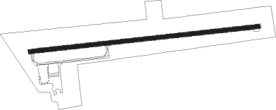
Runway info
| Runway 9 / 27 | ||
| length | 1248m (4094ft) | |
| bearing | 89° / 269° | |
| width | 23m (75ft) | |
| surface | asphalt | |
| displ threshold | 67m (220ft) / 115m (377ft) | |
Nearby beacons
| code | identifier | dist | bearing | frequency |
|---|---|---|---|---|
| APN | ALPENA VORTAC | 22.2 | 142° | 108.80 |
| AP | FELPS (ALPENA) NDB | 28.8 | 150° | 206 |
| PLN | PELLSTON VORTAC | 38.2 | 285° | 111.80 |
| GLR | GAYLORD VOR/DME | 44.5 | 246° | 109.20 |
| GL | BANGU (GAYLORD) NDB | 48.2 | 248° | 375 |
| CGG | GRAYLING VOR | 58.3 | 232° | 109.80 |
| ASP | SABLE (OSCODA) DME | 60.2 | 156° | 116.10 |
| CI | KOLOE (SAULT STE MARIE) NDB | 63.4 | 322° | 400 |
Instrument approach procedures
| runway | airway (heading) | route (dist, bearing) |
|---|---|---|
| RW09 | APN (322°) | APN REYOP (27mi, 294°) 2500ft JUPAK (5mi, 357°) 2500ft |
| RW09 | JUPAK (89°) | JUPAK 2500ft |
| RW09 | PLN (105°) | PLN JUPAK (28mi, 112°) 2500ft |
| RW09 | REEFY (160°) | REEFY MUKAE (19mi, 205°) 2500ft JUPAK (5mi, 177°) 2500ft |
| RNAV | JUPAK 2500ft KUCEK (6mi, 89°) 2500ft JADGA (3mi, 89°) 1600ft KPZQ (3mi, 89°) 704ft (5145mi, 118°) 1070ft ZUSIR (5134mi, 299°) 2300ft ZUSIR (turn) | |
| RW27 | APN (322°) | APN YUPUG (15mi, 1°) 2400ft ZUSIR (5mi, 358°) 2300ft |
| RW27 | PLN (105°) | PLN LULSE (47mi, 97°) 2400ft ZUSIR (5mi, 178°) 2300ft |
| RW27 | ZUSIR (269°) | ZUSIR 2300ft |
| RNAV | ZUSIR 2300ft DOHRI (6mi, 269°) 2200ft KPZQ (5mi, 269°) 703ft (5145mi, 118°) 1070ft JUPAK (5156mi, 298°) 2500ft JUPAK (turn) |
Disclaimer
The information on this website is not for real aviation. Use this data with the X-Plane flight simulator only! Data taken with kind consent from X-Plane 12 source code and data files. Content is subject to change without notice.