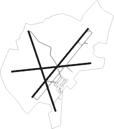
Walterboro - Lowcountry Regl
Airport details
| Country | United States of America |
| State | South Carolina |
| Region | K7 |
| Airspace | Jacksonville Ctr |
| Municipality | Colleton County |
| Elevation | 101ft (31m) |
| Timezone | GMT -5 |
| Coordinates | 32.92100, -80.64061 |
| Magnetic var | |
| Type | land |
| Available since | X-Plane v10.40 |
| ICAO code | KRBW |
| IATA code | RBW |
| FAA code | RBW |
Communication
| Lowcountry Regl AWOS 3 | 118.725 |
| Lowcountry Regl CTAF/UNICOM | 122.800 |
| Lowcountry Regl CHARLESTON Approach/Departure | 120.700 |
Approach frequencies
| ILS-cat-I | RW23 | 110.15 | 18.00mi |
| 3° GS | RW23 | 110.15 | 18.00mi |
Nearby Points of Interest:
Old Colleton County Jail
-Walterboro Historic District
-Walterboro Library Society Building
-Colleton County Courthouse
-Ravenwood Plantation
-Pon Pon Chapel
-Auldbrass Plantation
-Indian Fields Methodist Campground
-St. Paul Camp Ground
-Wilkinson-Boineau House
-Grove Plantation
-Southern Railway Passenger Depot
-Cohasett
-Summit Plantation House
-Old White Meeting House Ruins and Cemetery
-Hattie J. Peeples House
-Copeland House
-Francis Beidler Forest
-Hampton County Jail
-Prospect Hill
-American Legion Hut
-McLeod Farmstead
-Brick House Ruins
-Hampton County Courthouse
-Brookland Plantation
Runway info
Nearby beacons
| code | identifier | dist | bearing | frequency |
|---|---|---|---|---|
| DYB | DORCHESTER COUNTY(SUMMERVILLE) NDB | 20.1 | 69° | 365 |
| NBC | BEAUFORT TACAN | 26.8 | 190° | 110.50 |
| CH | ASHLY (CHARLESTON) NDB | 27.5 | 84° | 329 |
| CHS | CHARLESTON VORTAC | 30.4 | 93° | 113.50 |
| ALD | ALLENDALE VOR | 33.2 | 278° | 116.70 |
| VAN | VANCE VORTAC | 34.6 | 19° | 110.40 |
| MNI | MANNING NDB | 45.6 | 33° | 381 |
| JYL | SYLVANIA NDB | 50.8 | 254° | 245 |
| SAV | SAVANNAH VORTAC | 54.4 | 216° | 115.95 |
| SV | WASSA (SAVANNAH) NDB | 57.7 | 201° | 335 |
| CAE | COLUMBIA VORTAC | 59.9 | 336° | 114.70 |
| SVN | HUNTER (SAVANNAH) VOR/DME | 60.1 | 209° | 111.60 |
| CFY | EVANS (LAKE CITY) NDB | 71.2 | 43° | 420 |
Instrument approach procedures
| runway | airway (heading) | route (dist, bearing) |
|---|---|---|
| RW05 | MUTCY (49°) | MUTCY 2400ft |
| RNAV | MUTCY 2400ft LIBME (7mi, 49°) 1700ft REFOK (3mi, 49°) 760ft KRBW (2mi, 48°) 142ft (4934mi, 112°) 424ft LAMKE (4926mi, 292°) 2100ft LAMKE (turn) | |
| RW17 | ALD (98°) | ALD EZAFY (25mi, 82°) 2000ft IDIFI (5mi, 78°) 2000ft |
| RW17 | BOWMA (166°) | BOWMA IDIFI (13mi, 169°) 2000ft |
| RW17 | LAMKE (229°) | LAMKE WIVEL (7mi, 295°) 2000ft IDIFI (5mi, 258°) 2000ft |
| RNAV | IDIFI 2000ft WIBSI (6mi, 163°) 1700ft HETIL (1mi, 163°) 1300ft KRBW (4mi, 161°) 122ft (4934mi, 112°) 343ft LATNY (4932mi, 292°) CIGLO (8mi, 78°) LAMKE (12mi, 357°) 2100ft LAMKE (turn) | |
| RW23 | LAMKE (229°) | LAMKE 2100ft |
| RNAV | LAMKE 2100ft DOTMY (6mi, 229°) 1800ft KRBW (6mi, 229°) 144ft (4934mi, 112°) 1200ft LAMKE (4926mi, 292°) 2100ft LAMKE (turn) | |
| RW35 | ALD (98°) | ALD NIXGY (36mi, 116°) 2400ft DORLY (5mi, 78°) 2400ft |
| RW35 | CHS (273°) | CHS AHEFY (24mi, 253°) 2400ft DORLY (5mi, 258°) 2400ft |
| RNAV | DORLY 2400ft LATNY (6mi, 343°) 1700ft KRBW (5mi, 345°) 132ft (4934mi, 112°) 398ft WIBSI (4936mi, 292°) LAMKE (10mi, 73°) 2100ft LAMKE (turn) |
Disclaimer
The information on this website is not for real aviation. Use this data with the X-Plane flight simulator only! Data taken with kind consent from X-Plane 12 source code and data files. Content is subject to change without notice.

