Rockingham - Richmond County
Airport details
| Country | United States of America |
| State | North Carolina |
| Region | K7 |
| Airspace | Washington Ctr |
| Municipality | Richmond County |
| Elevation | 356ft (109m) |
| Timezone | GMT -5 |
| Coordinates | 34.89433, -79.75760 |
| Magnetic var | |
| Type | land |
| Available since | X-Plane v10.40 |
| ICAO code | KRCZ |
| IATA code | RCZ |
| FAA code | RCZ |
Communication
| Richmond County AWOS-3 | 118.775 |
| Richmond County CTAF/UNICOM | 122.800 |
| Richmond County FAYETTEVILLE Approach/Departure | 127.800 |
Nearby Points of Interest:
Covington Plantation House
-U. S. Post Office and Federal Building
-Richmond County Courthouse
-Rockingham County Courthouse
-Manufacturers Building
-Rockingham Historic District
-Bank of Pee Dee Building
-Main Street Commercial Historic District
-Roberdel Mill No. 1 Company Store
-Alfred Dockery House
-Pegues Place
-Naval Health Clinic Charleston
-Robertson-Easterling-McLaurin House
-Robert Smalls School
-Bostick School
-John Blue House
-E. Hervey Evans House
-Thomas J. Gill House
-Manship Farmstead
-Wadesboro Downtown Historic District
-Boggan-Hammond House and Alexander Little Wing
-United States Post Office
-Magnolia House
-Appin
-Laurinburg Commercial Historic District
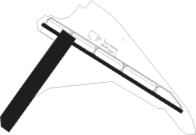
Runway info
Runway 14 / 32  | ||
| length | 1531m (5023ft) | |
| bearing | 121° / 301° | |
| width | 30m (98ft) | |
| surface | asphalt | |
| displ threshold | 46m (151ft) / 63m (207ft) | |
| Runway 04 / 22 | ||
| length | 932m (3058ft) | |
| bearing | 46° / 226° | |
| width | 152m (500ft) | |
| surface | grass | |
Nearby beacons
| code | identifier | dist | bearing | frequency |
|---|---|---|---|---|
| BES | BENNETTSVILLE NDB | 16.5 | 175° | 230 |
| ME | MAXTN (MAXTON) NDB | 18.2 | 117° | 257 |
| SDZ | SANDHILLS (SOUTHERN PINES VORTAC | 21 | 28° | 111.80 |
| UDG | DARLINGTON NDB | 27.8 | 196° | 245 |
| CTF | CHESTERFIELD VOR/DME | 29.4 | 245° | 108.20 |
| DLC | DILLON NDB | 32.8 | 139° | 274 |
| HVS | HARTSVILLE NDB | 34.3 | 217° | 341 |
| JB | JIGEL (LUMBERTON) NDB | 37 | 119° | 384 |
| VU | ALLER (ALBEMARLE) NDB | 39.1 | 331° | 346 |
| POB | POPE (FAYETTEVILLE) TACAN | 39.8 | 70° | 113.80 |
| FLO | FLORENCE VORTAC | 40 | 171° | 115.20 |
| FL | ALCOT (FLORENCE) NDB | 43.5 | 188° | 335 |
| FAY | FAYETTEVILLE VOR/DME | 43.7 | 84° | 108.80 |
| POB | POPE (FAYETTEVILLE) NDB | 44.2 | 68° | 338 |
| FGP | FORT BRAGG NDB | 48.7 | 75° | 393 |
| LIB | LIBERTY VORTAC | 55.5 | 9° | 113 |
| RU | ROVDY (SALISBURY) NDB | 61.8 | 319° | 275 |
| SMS | SUMTER NDB | 61.9 | 214° | 252 |
| SSC | SHAW (SUMTER) TACAN | 65.2 | 218° | 110.10 |
Instrument approach procedures
| runway | airway (heading) | route (dist, bearing) |
|---|---|---|
| RW32 | HODOG (302°) | HODOG 2100ft |
| RW32 | RAEFO (260°) | RAEFO HODOG (15mi, 227°) 2100ft |
| RW32 | TOWEY (332°) | TOWEY HODOG (8mi, 21°) 2100ft |
| RNAV | HODOG 2100ft ZIPPO (6mi, 301°) 1900ft NIGTE (3mi, 301°) 900ft KRCZ (2mi, 304°) 395ft CUPLI (5mi, 300°) NIMDE (7mi, 61°) RAEFO (17mi, 98°) 2400ft RAEFO (turn) |
Disclaimer
The information on this website is not for real aviation. Use this data with the X-Plane flight simulator only! Data taken with kind consent from X-Plane 12 source code and data files. Content is subject to change without notice.