Red Oak - Red Oak Muni
Airport details
| Country | United States of America |
| State | Iowa |
| Region | K3 |
| Airspace | Minneapolis Ctr |
| Municipality | Montgomery County |
| Elevation | 1042ft (318m) |
| Timezone | GMT -6 |
| Coordinates | 41.01083, -95.25886 |
| Magnetic var | |
| Type | land |
| Available since | X-Plane v10.40 |
| ICAO code | KRDK |
| IATA code | n/a |
| FAA code | RDK |
Communication
| Red Oak Muni AWOS 3 | 119.775 |
| Red Oak Muni CTAF | 122.800 |
Nearby Points of Interest:
Montgomery County Courthouse
-Red Oak Public Library
-Thos. D. Murphy Co. Factory and Power Plant
-Chicago, Burlington Northern and Quincy Depot
-Red Oak Downtown Historic District
-Red Oak Firehouse and City Jail
-Alfred Hebard House
-Nodaway River Bridge
-Josiah B. and Sara Moore House
-Noah Odell House
-Clarinda Carnegie Library
-Page County Courthouse
-Nishnabotna Ferry House
-Goldenrod Schoolhouse
-Todd House
-Hunter School
-Fremont County Courthouse
-Adams County Jail
-Corning Commercial Historic District
-Chautauqua Pavilion
-Charles F. and Ruth Chase House
-Cass County Courthouse
-Hotel Whitney
-American Legion Memorial Building
-Chicago, Rock Island & Pacific Railroad Depot
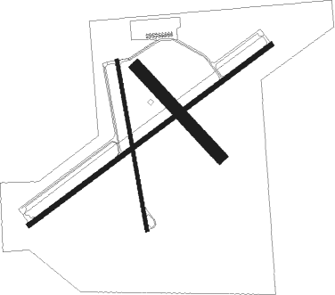
Runway info
Runway 5 / 23  | ||
| length | 1556m (5105ft) | |
| bearing | 65° / 245° | |
| width | 23m (75ft) | |
| surface | concrete | |
| displ threshold | 305m (1001ft) / 0m (0ft) | |
| Runway 17 / 35 | ||
| length | 885m (2904ft) | |
| bearing | 173° / 353° | |
| width | 18m (60ft) | |
| surface | concrete | |
| blast zone | 137m (449ft) / 91m (299ft) | |
| Runway 13 / 31 | ||
| length | 625m (2051ft) | |
| bearing | 134° / 314° | |
| width | 64m (210ft) | |
| surface | grass | |
Nearby beacons
| code | identifier | dist | bearing | frequency |
|---|---|---|---|---|
| OVR | OMAHA VORTAC | 23.5 | 288° | 116.30 |
| OFF | OFFUTT (OMAHA) TACAN | 29.7 | 279° | 111.70 |
| PMV | PLATTSMOUTH NDB | 29.9 | 264° | 329 |
| AFK | NEBRASKA CITY NDB | 36.6 | 236° | 347 |
| PWE | PAWNEE CITY VORTAC | 65 | 229° | 112.40 |
Instrument approach procedures
| runway | airway (heading) | route (dist, bearing) |
|---|---|---|
| RW05 | INIHI (64°) | INIHI 6000ft INIHI (turn) 3000ft |
| RW05 | OVR (108°) | OVR EKEGE (14mi, 131°) 3400ft INIHI (6mi, 140°) 3000ft |
| RW05 | SAJHO (286°) | SAJHO ZISOR (16mi, 247°) 3000ft INIHI (6mi, 320°) 3000ft |
| RW05 | VIKKI (26°) | VIKKI ZISOR (8mi, 6°) 3000ft INIHI (6mi, 320°) 3000ft |
| RNAV | INIHI 3000ft KUWFY (6mi, 64°) 2700ft ZELAG (3mi, 65°) 1740ft KRDK (2mi, 64°) 1082ft (5643mi, 113°) 1363ft HOBEG (5639mi, 293°) SAJHO (7mi, 140°) 3000ft SAJHO (turn) | |
| RW17 | EYNOR (147°) | EYNOR ULAZO (5mi, 100°) 3000ft |
| RW17 | PSFIC (226°) | PSFIC IYETA (9mi, 251°) 3000ft ULAZO (5mi, 266°) 3000ft |
| RW17 | SAJHO (286°) | SAJHO IYETA (15mi, 340°) 3000ft ULAZO (5mi, 266°) 3000ft |
| RNAV | ULAZO 3000ft OVEDY (6mi, 173°) 2700ft KRDK (5mi, 172°) 1089ft CIBVI (5mi, 173°) SAJHO (8mi, 77°) 3000ft SAJHO (turn) |
Disclaimer
The information on this website is not for real aviation. Use this data with the X-Plane flight simulator only! Data taken with kind consent from X-Plane 12 source code and data files. Content is subject to change without notice.