Rhinelander - Rhinelander-oneida Co
Airport details
| Country | United States of America |
| State | Wisconsin |
| Region | K5 |
| Airspace | Minneapolis Ctr |
| Municipality | Rhinelander |
| Elevation | 1624ft (495m) |
| Timezone | GMT -6 |
| Coordinates | 45.63090, -89.46663 |
| Magnetic var | |
| Type | land |
| Available since | X-Plane v10.40 |
| ICAO code | KRHI |
| IATA code | RHI |
| FAA code | RHI |
Communication
| Rhinelander-Oneida Co ASOS | 126.825 |
| Rhinelander-Oneida Co CTAF/UNICOM | 123.000 |
Approach frequencies
| ILS-cat-I | RW09 | 111.3 | 18.00mi |
| 3° GS | RW09 | 111.3 | 18.00mi |
Nearby Points of Interest:
First National Bank
-Oneida County Courthouse
-Solon and Mathilda Sutliff House
-Sunset Point
-Anvil Lake Campground Shelter
-Bose Lake Hemlock Hardwoods
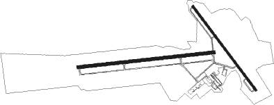
Runway info
Runway 15 / 33  | ||
| length | 1585m (5200ft) | |
| bearing | 138° / 318° | |
| width | 30m (100ft) | |
| surface | asphalt | |
| Runway 9 / 27 | ||
| length | 2066m (6778ft) | |
| bearing | 89° / 269° | |
| width | 46m (150ft) | |
| surface | concrete | |
| blast zone | 32m (105ft) / 0m (0ft) | |
Nearby beacons
| code | identifier | dist | bearing | frequency |
|---|---|---|---|---|
| RHI | RHINELANDER VOR/DME | 0.4 | 72° | 109.20 |
| RH | ARSHA (RHINELANDER) NDB | 6.3 | 269° | 272 |
| DO | DOUGY (MINOCQUA WOODRUFF) NDB | 16.4 | 308° | 236 |
| RXW | WATERSMEET NDB | 40.2 | 16° | 407 |
| AUW | WAUSAU VOR/DME | 47.3 | 189° | 111.60 |
| IWD | IRONWOOD VOR/DME | 60.6 | 324° | 108.80 |
Instrument approach procedures
| runway | airway (heading) | route (dist, bearing) |
|---|---|---|
| RW09 | CINEX (115°) | CINEX ECANA (9mi, 177°) 3500ft |
| RW09 | FASUX (71°) | FASUX ECANA (6mi, 357°) 3500ft |
| RW09 | RHI (252°) | RHI ECANA (13mi, 268°) 4000ft ECANA (turn) 3500ft |
| RNAV | ECANA 3500ft GATRE (6mi, 89°) 3500ft ZINGI (4mi, 89°) 2280ft KRHI (3mi, 89°) 1676ft (5383mi, 117°) 1824ft BADAY (5370mi, 297°) 4500ft BADAY (turn) | |
| RW15 | CESSI (145°) | CESSI DECET (9mi, 154°) 4000ft |
| RW15 | GOLYE (115°) | GOLYE DECET (11mi, 94°) 4000ft |
| RW15 | RHI (252°) | RHI DECET (12mi, 317°) 4000ft DECET (turn) 4000ft |
| RNAV | DECET 4000ft CIDEB (7mi, 138°) 3400ft OZAMI (3mi, 138°) 2280ft KRHI (2mi, 147°) 1651ft (5383mi, 117°) 1980ft CIREN (5376mi, 297°) 3500ft CIREN (turn) | |
| RW27 | CAYAN (262°) | CAYAN BADAY (6mi, 244°) 4500ft |
| RW27 | DADYE (283°) | DADYE BADAY (9mi, 310°) 4500ft |
| RW27 | RHI (252°) | RHI BADAY (13mi, 89°) 4500ft BADAY (turn) 4500ft |
| RNAV | BADAY 4500ft WAMDU (6mi, 269°) 3900ft OGOSE (5mi, 269°) 2420ft KRHI (3mi, 269°) 1649ft (5383mi, 117°) 1806ft ECANA (5396mi, 297°) 4000ft ECANA (turn) | |
| RW33 | DADYE (283°) | DADYE CIREN (12mi, 256°) 3500ft |
| RW33 | RHI (252°) | RHI CIREN (12mi, 138°) 4000ft CIREN (turn) 3500ft |
| RW33 | YANUT (8°) | YANUT CIREN (11mi, 61°) 3500ft |
| RNAV | CIREN 3500ft DEBBA (7mi, 318°) 3400ft KRHI (6mi, 314°) 1661ft (5383mi, 117°) 1862ft CIDEB (5386mi, 297°) 4000ft ECANA (11mi, 249°) 4000ft ECANA (turn) |
Disclaimer
The information on this website is not for real aviation. Use this data with the X-Plane flight simulator only! Data taken with kind consent from X-Plane 12 source code and data files. Content is subject to change without notice.