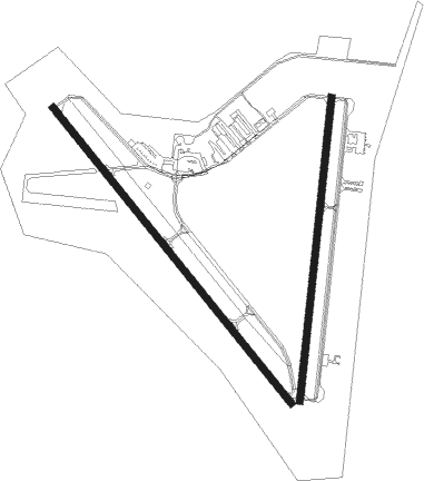
Rockport - Aransas Co
Airport details
| Country | United States of America |
| State | Texas |
| Region | K4 |
| Airspace | Houston Oceanic Ctr |
| Municipality | Aransas County |
| Elevation | 21ft (6m) |
| Timezone | GMT -6 |
| Coordinates | 28.09240, -97.04101 |
| Magnetic var | |
| Type | land |
| Available since | X-Plane v10.30 |
| ICAO code | KRKP |
| IATA code | RKP |
| FAA code | RKP |
Communication
| Aransas Co ASOS | 119.275 |
| Aransas Co CTAF/UNICOM | 123.050 |
| Aransas Co CORPUS Approach/Departure | 120.900 |
Nearby beacons
| code | identifier | dist | bearing | frequency |
|---|---|---|---|---|
| CRP | CORPUS CHRISTI VORTAC | 24.2 | 245° | 115.50 |
| NGP | TRUAX (CORPUS CHRISTI) TACAN | 27.8 | 212° | 114 |
| VCT | VICTORIA VOR/DME | 48.6 | 4° | 109 |
| NQI | KINGSVILLE TACAN | 54 | 232° | 117.80 |
| PSX | PALACIOS VORTAC | 55.9 | 48° | 117.30 |
| ALI | ALICE VOR | 56.1 | 250° | 114.50 |
Instrument approach procedures
| runway | airway (heading) | route (dist, bearing) |
|---|---|---|
| RW14 | BETZY (220°) | BETZY OGERE (10mi, 282°) 2000ft COPIR (5mi, 239°) 2000ft |
| RW14 | SKIDS (98°) | SKIDS YAGYA (29mi, 92°) 2000ft COPIR (5mi, 59°) 2000ft |
| RNAV | COPIR 2000ft NUEAR (6mi, 142°) 1400ft KRKP (5mi, 136°) 50ft PITYI (7mi, 146°) 2000ft PITYI (turn) | |
| RW18 | BETZY (220°) | BETZY UDLAY (5mi, 279°) 2000ft |
| RW18 | SKIDS (98°) | SKIDS ZARBA (37mi, 84°) 2000ft UDLAY (5mi, 99°) 2000ft |
| RNAV | UDLAY 2000ft OLUSE (6mi, 192°) 1400ft KYLND (2mi, 192°) 660ft KRKP (2mi, 196°) 59ft YAYUR (4mi, 190°) PITYI (4mi, 112°) 2000ft PITYI (turn) | |
| RW32 | BETZY (220°) | BETZY FIKIP (16mi, 168°) 2000ft JAMWU (5mi, 239°) 2000ft |
| RW32 | SKIDS (98°) | SKIDS HESUD (46mi, 112°) 2100ft JAMWU (5mi, 59°) 2000ft |
| RNAV | JAMWU 2000ft EKXES (6mi, 322°) 1400ft KRKP (5mi, 328°) 64ft COPIR (11mi, 320°) 2000ft COPIR (turn) | |
| RW36 | BETZY (220°) | BETZY VIYQI (22mi, 192°) 2000ft NENDE (5mi, 279°) 2000ft |
| RW36 | SKIDS (98°) | SKIDS GEYXI (37mi, 114°) 2100ft NENDE (5mi, 99°) 2000ft |
| RNAV | NENDE 2000ft XEPHO (6mi, 12°) 1400ft IMETE (2mi, 12°) 700ft KRKP (3mi, 9°) 65ft UDLAY (10mi, 13°) 2000ft UDLAY (turn) |
Disclaimer
The information on this website is not for real aviation. Use this data with the X-Plane flight simulator only! Data taken with kind consent from X-Plane 12 source code and data files. Content is subject to change without notice.

