Rochester - Greater Rochester Intl
Airport details
| Country | United States of America |
| State | New York |
| Region | K6 |
| Airspace | Cleveland Ctr |
| Municipality | City of Rochester |
| Elevation | 559ft (170m) |
| Timezone | GMT -5 |
| Coordinates | 43.11914, -77.67187 |
| Magnetic var | |
| Type | land |
| Available since | X-Plane v10.40 |
| ICAO code | KROC |
| IATA code | ROC |
| FAA code | ROC |
Communication
| Greater Rochester Intl ATIS | 124.825 |
| Greater Rochester Intl UNICOM | 122.950 |
| Greater Rochester Intl Clearance DEL | 118.800 |
| Greater Rochester Intl Ground Control | 121.700 |
| Greater Rochester Intl Tower | 118.300 |
| Greater Rochester Intl Approach | 119.550 |
| Greater Rochester Intl Approach | 123.700 |
| Greater Rochester Intl Departure | 119.550 |
| Greater Rochester Intl Departure | 123.700 |
Approach frequencies
| ILS-cat-II | RW04 | 110.7 | 18.00mi |
| ILS-cat-I | RW22 | 110.7 | 18.00mi |
| ILS-cat-I | RW28 | 109.5 | 18.00mi |
| 3° GS | RW04 | 110.7 | 18.00mi |
| 3° GS | RW22 | 110.7 | 18.00mi |
| 3° GS | RW28 | 109.5 | 18.00mi |
Nearby Points of Interest:
Franklin Hinchey House
-Arvine Heights Historic District
-Inglewood and Thurston Historic District
-Sibley–Elmdorf Historic District
-Chili–West Historic District
-Emmanuel Presbyterian Church
-O'Kane Market and O'Kane Building
-House at 235–237 Reynolds Street
-Church of Saints Peter and Paul Complex
-Mount Hope-Highland Historic District
-Hervey Ely House
-Nazareth House
-Linden-South Historic District
-Jonathan Child House & Brewster–Burke House Historic District
-Bevier Memorial Building
-First Presbyterian Church
-Saint Andrew's Episcopal Church
-Campbell-Whittlesey House
-Washington Street Rowhouses
-Rochester City School No. 24
-Ebenezer Watts House
-Timothy Wallace House
-City Hall Historic District
-Court–Exchange Building
-Old Stone Warehouse
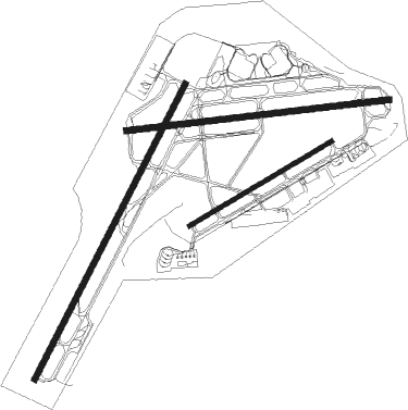
Runway info
Runway 4 / 22  | ||
| length | 2440m (8005ft) | |
| bearing | 40° / 220° | |
| width | 46m (150ft) | |
| surface | asphalt | |
| blast zone | 12m (39ft) / 12m (39ft) | |
| Runway 10 / 28 | ||
| length | 1947m (6388ft) | |
| bearing | 88° / 268° | |
| width | 46m (150ft) | |
| surface | asphalt | |
| displ threshold | 91m (299ft) / 183m (600ft) | |
| blast zone | 130m (427ft) / 7m (23ft) | |
| Runway 7 / 25 | ||
| length | 1218m (3996ft) | |
| bearing | 70° / 250° | |
| width | 30m (100ft) | |
| surface | asphalt | |
| blast zone | 46m (151ft) / 46m (151ft) | |
Nearby beacons
| code | identifier | dist | bearing | frequency |
|---|---|---|---|---|
| ROC | ROCHESTER VOR/DME | 0 | 218° | 110 |
| GEE | GENESEO VOR/DME | 17.3 | 192° | 108.20 |
| PYA | PENN YAN NDB | 39.3 | 128° | 260 |
| BU | KLUMP (BUFFALO) NDB | 43.5 | 263° | 231 |
| BUF | BUFFALO VOR/DME | 44.2 | 259° | 116.40 |
| ZZR | SEVERN (TRENTON) NDB | 56.1 | 3° | 317 |
| ALP | ALPINE (ELMIRA) NDB | 66.3 | 134° | 245 |
Instrument approach procedures
| runway | airway (heading) | route (dist, bearing) |
|---|---|---|
| RW04 | GEE (12°) | GEE FEPUG (7mi, 313°) 2600ft |
| RNAV | FEPUG 2600ft WORIS (8mi, 40°) 2000ft KROC (5mi, 42°) 583ft (4867mi, 119°) 1500ft BILAW (4855mi, 299°) 3000ft BILAW (turn) | |
| RW07 | FIXUS (70°) | FIXUS HITOX (7mi, 70°) 2600ft |
| RW07 | WELTI (46°) | WELTI HITOX (8mi, 5°) 2600ft |
| RNAV | HITOX 2600ft CEPAG (6mi, 70°) 1800ft KROC (4mi, 68°) 590ft (4867mi, 119°) 1500ft BILAW (4855mi, 299°) 3000ft BILAW (turn) | |
| RW10 | CLUNG (79°) | CLUNG ZOFEB (5mi, 57°) 2500ft |
| RW10 | GEE (12°) | GEE WIGEG (12mi, 311°) 3400ft ZOFEB (8mi, 357°) 2500ft |
| RNAV | ZOFEB 2500ft BIBAY (7mi, 88°) 1700ft KROC (4mi, 91°) 605ft (4867mi, 119°) 959ft BILAW (4855mi, 299°) 3000ft BILAW (turn) | |
| RW22 | CLUNG (79°) | CLUNG ZOGOB (18mi, 34°) 3800ft WIKCI (8mi, 76°) 3000ft KECKE (7mi, 114°) 3000ft |
| RW22 | MAGEN (268°) | MAGEN ZOMUM (10mi, 300°) 3800ft KECKE (8mi, 294°) 3000ft |
| RNAV | KECKE 3000ft CAPLU (7mi, 220°) 2500ft KROC (6mi, 218°) 609ft (4867mi, 119°) 759ft FIDBA (4868mi, 299°) GEE (14mi, 183°) 4000ft GEE (turn) | |
| RW28 | FAULT (294°) | FAULT BILAW (9mi, 350°) 2400ft |
| RW28 | MAGEN (268°) | MAGEN BILAW (9mi, 269°) 2400ft |
| RNAV | BILAW 2400ft SUUSA (7mi, 268°) 2100ft KROC (5mi, 267°) 598ft (4867mi, 119°) 791ft CEMIG (4869mi, 299°) MONCK (8mi, 255°) 3000ft MONCK (turn) |
Disclaimer
The information on this website is not for real aviation. Use this data with the X-Plane flight simulator only! Data taken with kind consent from X-Plane 12 source code and data files. Content is subject to change without notice.