Graham - Graham Municipal
Airport details
| Country | United States of America |
| State | Texas |
| Region | K4 |
| Airspace | Ft Worth Ctr |
| Municipality | Graham |
| Elevation | 1123ft (342m) |
| Timezone | GMT -6 |
| Coordinates | 33.11072, -98.55478 |
| Magnetic var | |
| Type | land |
| Available since | X-Plane v10.40 |
| ICAO code | KRPH |
| IATA code | n/a |
| FAA code | RPH |
Communication
Nearby Points of Interest:
Fort Richardson
-Jack County Courthouse
-Archer County Courthouse and Jail
-Throckmorton County Courthouse and Jail
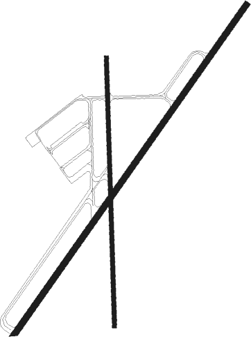
Runway info
Runway 3 / 21  | ||
| length | 1525m (5003ft) | |
| bearing | 45° / 225° | |
| width | 23m (75ft) | |
| surface | asphalt | |
| Runway 18 / 36 | ||
| length | 1014m (3327ft) | |
| bearing | 183° / 3° | |
| width | 15m (50ft) | |
| surface | asphalt | |
| displ threshold | 193m (633ft) / 0m (0ft) | |
Nearby beacons
| code | identifier | dist | bearing | frequency |
|---|---|---|---|---|
| GHX | GRAHAM NDB | 4.4 | 47° | 371 |
| MQP | MILLSAP (MINERAL WELLS) VORTAC | 36.3 | 125° | 117.70 |
| SKB | SCOTLAND (WICHITA FALLS) NDB | 40.4 | 6° | 344 |
| UKW | BOWIE VORTAC | 44.7 | 60° | 117.15 |
| SHP | SHEPPARD (WICHITA FALLS) TACAN | 52.4 | 4° | 110.80 |
| SPS | WICHITA FALLS VORTAC | 52.6 | 357° | 112.70 |
| JEN | GLEN ROSE TACAN | 66.6 | 145° | 115 |
Instrument approach procedures
| runway | airway (heading) | route (dist, bearing) |
|---|---|---|
| RW03 | MQP (305°) | MQP LEBLE (33mi, 286°) 3500ft NOCID (5mi, 305°) 3200ft |
| RW03 | NOCID (44°) | NOCID 3200ft |
| RW03 | VAYTU (111°) | VAYTU CIYAL (16mi, 144°) 3500ft NOCID (7mi, 125°) 3200ft |
| RNAV | NOCID 3200ft FESUB (6mi, 44°) 2700ft KRPH (5mi, 44°) 1154ft IROTE (7mi, 45°) VAYTU (26mi, 278°) 3900ft VAYTU (turn) | |
| RW21 | MQP (305°) | MQP MODNE (33mi, 325°) 3500ft JIPOG (5mi, 305°) 3200ft |
| RW21 | VAYTU (111°) | VAYTU HIKOT (24mi, 85°) 3500ft JIPOG (5mi, 125°) 3200ft |
| RNAV | JIPOG 3200ft SOMOE (6mi, 225°) 2700ft ZEKUL (2mi, 225°) 2100ft KRPH (3mi, 225°) 1154ft FESUB (5mi, 224°) VAYTU (22mi, 303°) 3900ft VAYTU (turn) |
Disclaimer
The information on this website is not for real aviation. Use this data with the X-Plane flight simulator only! Data taken with kind consent from X-Plane 12 source code and data files. Content is subject to change without notice.