Russell - Russell Muni
Airport details
| Country | United States of America |
| State | Kansas |
| Region | K3 |
| Airspace | Kansas City Ctr |
| Municipality | Russell |
| Elevation | 1859ft (567m) |
| Timezone | GMT -6 |
| Coordinates | 38.87136, -98.81160 |
| Magnetic var | |
| Type | land |
| Available since | X-Plane v10.40 |
| ICAO code | KRSL |
| IATA code | RSL |
| FAA code | RSL |
Communication
| Russell Muni ASOS | 128.325 |
| Russell Muni CTAF/UNICOM | 122.700 |
Nearby Points of Interest:
Paradise Water Tower
-Natoma Presbyterian Church
-St. Joseph's Church and Parochial School
-Meades Ranch Triangulation Station
-Cheyenne Bottoms
-Danske Evangelist Lutheran Kirke
-Nagel House
-Rush County Courthouse
Runway info
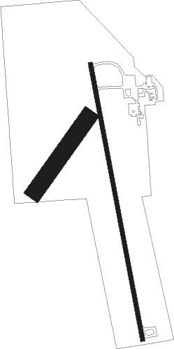
Runway 17 / 35  | ||
| length | 1525m (5003ft) | |
| bearing | 172° / 352° | |
| width | 23m (75ft) | |
| surface | concrete | |
| Runway 03 / 21 | ||
| length | 489m (1604ft) | |
| bearing | 47° / 227° | |
| width | 91m (300ft) | |
| surface | dirt | |
Nearby beacons
| code | identifier | dist | bearing | frequency |
|---|---|---|---|---|
| HY | NETTE (HAYS) NDB | 21.4 | 257° | 374 |
| HYS | HAYS VORTAC | 21.8 | 267° | 110.40 |
| GB | BABSY NDB | 37.2 | 184° | 419 |
| HU | SALTT (HUTCHINSON) NDB | 61.2 | 130° | 404 |
| TKO | MANKATO VORTAC | 61.7 | 31° | 109.80 |
| HUT | HUTCHINSON VOR/DME | 66.7 | 135° | 116.80 |
Instrument approach procedures
| runway | airway (heading) | route (dist, bearing) |
|---|---|---|
| RW17 | BUNVY (201°) | BUNVY 4000ft EDITE (5mi, 265°) 4000ft |
| RW17 | EDITE (172°) | EDITE 4000ft |
| RW17 | LARPY (145°) | LARPY 4000ft EDITE (5mi, 85°) 4000ft |
| RNAV | EDITE 4000ft AYCUF (7mi, 172°) 3500ft KRSL (5mi, 172°) 1896ft BAQFO (12mi, 172°) 4000ft BAQFO (turn) | |
| RW35 | BAQFO (352°) | BAQFO 4000ft |
| RW35 | CUTNI (20°) | CUTNI 4000ft BAQFO (5mi, 85°) 4000ft |
| RW35 | DUNOQ (325°) | DUNOQ 4000ft BAQFO (5mi, 265°) 4000ft |
| RNAV | BAQFO 4000ft AMUKE (7mi, 352°) 3500ft KRSL (5mi, 352°) 1896ft EDITE (12mi, 352°) 4000ft EDITE (turn) |
Disclaimer
The information on this website is not for real aviation. Use this data with the X-Plane flight simulator only! Data taken with kind consent from X-Plane 12 source code and data files. Content is subject to change without notice.