Rutland - Rutland Southern Vermont Rgnl
Airport details
| Country | United States of America |
| State | Vermont |
| Region | K6 |
| Airspace | Boston Ctr |
| Municipality | Clarendon |
| Elevation | 787ft (240m) |
| Timezone | GMT -5 |
| Coordinates | 43.52991, -72.94964 |
| Magnetic var | |
| Type | land |
| Available since | X-Plane v10.40 |
| ICAO code | KRUT |
| IATA code | RUT |
| FAA code | RUT |
Communication
| Rutland Southern Vermont Rgnl AWOS 3 | 118.375 |
| Rutland Southern Vermont Rgnl CTAF/UNICOM | 122.800 |
Approach frequencies
| ILS-cat-I | RW19 | 111.7 | 18.00mi |
| 3.2° GS | RW19 | 111.7 | 18.00mi |
Nearby Points of Interest:
East Clarendon Railroad Station
-Cold River Bridge
-Clarendon House
-Arthur Perkins House
-Homer Waldo Farm
-Clementwood
-Longfellow School
-Linden Terrace
-West Rutland Town Hall
-Hager Farm
-Proctor-Clement House
-Hulett Farm
-Anthony Scoville House
-Marble Bridge
-Coolidge Homestead
-Plymouth Historic District
-Thomas H. Palmer House
-Colburn Bridge
-Hosford-Sherman Farm
-South Street Bridge
-Hydeville School
-Bridgewater Corners Bridge
-Ludlow Graded School
-Brook Farm
-Zachariah Spaulding Farm
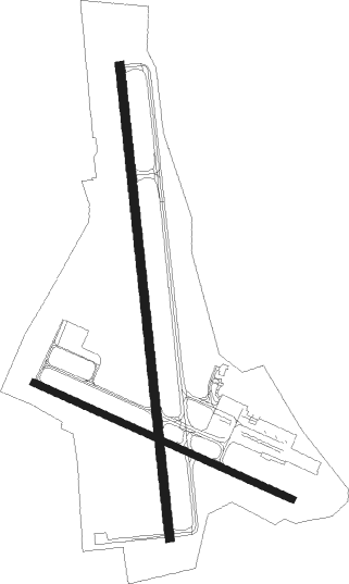
Runway info
Runway 1 / 19  | ||
| length | 1617m (5305ft) | |
| bearing | 358° / 178° | |
| width | 30m (100ft) | |
| surface | asphalt | |
| displ threshold | 91m (299ft) / 0m (0ft) | |
| blast zone | 95m (312ft) / 0m (0ft) | |
| Runway 13 / 31 | ||
| length | 965m (3166ft) | |
| bearing | 112° / 292° | |
| width | 23m (75ft) | |
| surface | asphalt | |
Nearby beacons
| code | identifier | dist | bearing | frequency |
|---|---|---|---|---|
| RUT | DME | 0.1 | 199° | 111 |
| DYO | SMUTO (RUTLAND) NDB | 10.5 | 358° | 221 |
| CNH | CLAREMONT NDB | 27 | 106° | 233 |
| GF | GANSE (GLENS FALLS) NDB | 33 | 247° | 209 |
| LEB | DME | 33.1 | 79° | 113.70 |
| LAH | HANOVER (LEBANON) NDB | 35.1 | 77° | 276 |
| CAM | CAMBRIDGE VOR/DME | 36.5 | 216° | 115 |
| MPV | MONTPELIER VOR/DME | 39.7 | 42° | 116.90 |
| EEN | DME | 52.7 | 138° | 109.40 |
| BTV | BURLINGTON VOR/DME | 53 | 345° | 117.50 |
| AL | HAWKY (ALBANY) NDB | 56.9 | 230° | 219 |
| BJA | BURLINGTON TACAN | 57.5 | 348° | 112.40 |
| HEU | HUNTER (SCHENECTADY) NDB | 59.1 | 236° | 356 |
| ALB | ALBANY VORTAC | 60 | 227° | 115.30 |
| GDM | GARDNER VOR/DME | 70.8 | 138° | 110.60 |
Instrument approach procedures
| runway | airway (heading) | route (dist, bearing) |
|---|---|---|
| RW01 | CAM (36°) | CAM WETID (19mi, 47°) 6100ft JUVIM (4mi, 49°) 5300ft |
| RW01 | JAMMA (306°) | JAMMA UCEKU (15mi, 262°) 6000ft JUVIM (6mi, 308°) 5300ft |
| RW01 | JUVIM (15°) | JUVIM 5300ft |
| RNAV | JUVIM 5300ft VOCUY (3mi, 355°) 4900ft WIRAX (4mi, 24°) 3700ft CARVO (7mi, 20°) 1017ft (4668mi, 121°) 1187ft DABTE (4676mi, 301°) 5700ft DABTE (turn) | |
| RW19-Y | BTV (165°) | BTV GITKE (37mi, 159°) 5700ft |
| RW19-Y | JOGIM (68°) | JOGIM GITKE (30mi, 41°) 5700ft GITKE (turn) 5700ft |
| RW19-Y | MPV (222°) | MPV GITKE (28mi, 242°) 5700ft |
| RNAV | GITKE 5700ft LECEG (4mi, 178°) 4800ft CEKRA (4mi, 178°) 3900ft KRUT (10mi, 178°) 828ft (4668mi, 121°) 2700ft JOGIM (4682mi, 301°) 5700ft JOGIM (turn) 5700ft | |
| RW19-Z | BTV (165°) | BTV GITKE (37mi, 159°) 5700ft |
| RW19-Z | JOGIM (68°) | JOGIM GITKE (30mi, 41°) 5700ft GITKE (turn) 5700ft |
| RW19-Z | MPV (222°) | MPV GITKE (28mi, 242°) 5700ft |
| RNAV | GITKE 5700ft LECEG (4mi, 178°) 4800ft CEKRA (4mi, 178°) 3900ft CIBTO (3mi, 178°) 2900ft KRUT (7mi, 178°) 828ft (4668mi, 121°) 1500ft JOGIM (4682mi, 301°) 5700ft JOGIM (turn) 5700ft |
Disclaimer
The information on this website is not for real aviation. Use this data with the X-Plane flight simulator only! Data taken with kind consent from X-Plane 12 source code and data files. Content is subject to change without notice.