Tucson - Ryan Fld
Airport details
| Country | United States of America |
| State | Arizona |
| Region | K2 |
| Airspace | Albuquerque Ctr |
| Municipality | Pima County |
| Elevation | 2416ft (736m) |
| Timezone | GMT -7 |
| Coordinates | 32.14222, -111.17458 |
| Magnetic var | |
| Type | land |
| Available since | X-Plane v10.40 |
| ICAO code | KRYN |
| IATA code | n/a |
| FAA code | RYN |
Communication
| Ryan Fld AWOS 3 | 133.350 |
| Ryan Fld CTAF | 125.800 |
| Ryan Fld Ground Control | 118.200 |
| Ryan Fld Tower | 125.800 |
| Ryan Fld TUCSON Approach | 273.600 |
| Ryan Fld TUCSON Departure | 273.600 |
Approach frequencies
| ILS-cat-I | RW06R | 111.1 | 18.00mi |
| 3° GS | RW06R | 111.1 | 18.00mi |
Nearby Points of Interest:
Copper Bell Bed and Breakfast
-Barrio El Membrillo Historic District
-El Paso and Southwestern Railroad Depot
-El Tiradito
-Barrio Santa Rosa
-Santa Cruz Catholic Church
-Sosa-Carrillo-Fremont House
-Pima County Courthouse
-Valley National Bank Building
-Fox Commercial Building
-USDA Tucson Plant Materials Center
-James A. Walsh United States Courthouse
-J. C. Penney–Chicago Store Building
-Stone Avenue Underpass
-Julian-Drew Building
-Miracle Mile Historic District
-Coronado Hotel
-University of Arizona Campus Historic District
-Colonia Solana Residential Historic District
-Catalina American Baptist Church
-St. Philip's in the Hills Episcopal Church
-San Pedro Chapel
-DeGrazia Gallery in the Sun Historic District
-Lowell Ranger Station
-Lemmon Rock Lookout House
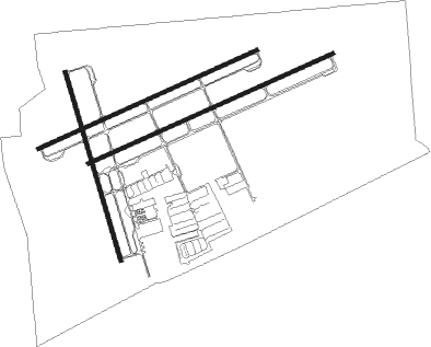
Runway info
Runway 6R / 24L  | ||
| length | 1675m (5495ft) | |
| bearing | 73° / 253° | |
| width | 23m (75ft) | |
| surface | asphalt | |
| blast zone | 0m (0ft) / 152m (499ft) | |
| Runway 6L / 24R | ||
| length | 1494m (4902ft) | |
| bearing | 73° / 253° | |
| width | 23m (75ft) | |
| surface | asphalt | |
| Runway 15 / 33 | ||
| length | 1226m (4022ft) | |
| bearing | 166° / 346° | |
| width | 23m (75ft) | |
| surface | asphalt | |
Nearby beacons
| code | identifier | dist | bearing | frequency |
|---|---|---|---|---|
| RYN | RYAN (TUCSON) NDB | 0.6 | 105° | 338 |
| RBJ | ROBLES (TUCSON) NDB | 10.2 | 250° | 220 |
| TUS | TUCSON VORTAC | 13.5 | 100° | 116 |
| DMA | DAVIS-MONTHAN (TUCSON) TACAN | 14.9 | 87° | 117.60 |
| AVQ | MARANA NDB | 16.3 | 351° | 245 |
| OLS | NOGALES VOR/DME | 46.7 | 156° | 108.20 |
| FHU | LIBBY (FT HUACHUCA) VOR/DME | 53.3 | 124° | 113.60 |
| ARH | FORT HUACHUCA TACAN | 54.1 | 124° | 111.60 |
| TFD | STANFIELD (CASA GRANDE) VORTAC | 58.1 | 315° | 114.80 |
Departure and arrival routes
| Transition altitude | 18000ft |
| Transition level | 18000ft |
| SID end points | distance | outbound heading | |
|---|---|---|---|
| RW06R | |||
| ALMON1 | 22mi | 307° | |
| RW24L | |||
| ALMON1 | 22mi | 307° | |
Instrument approach procedures
| runway | airway (heading) | route (dist, bearing) |
|---|---|---|
| RW06R | ALMON (127°) | ALMON JIPSY (11mi, 181°) 7000ft HILIX (9mi, 136°) 5800ft |
| RW06R | TUS (280°) | TUS HILIX (24mi, 268°) 5900ft HILIX (turn) 5800ft |
| RNAV | HILIX 5800ft WIKIM (4mi, 73°) 4500ft XOXUJ (6mi, 73°) 2706ft (6476mi, 106°) 2900ft JIPSY (6490mi, 286°) 7000ft JIPSY (turn) 7000ft |
Disclaimer
The information on this website is not for real aviation. Use this data with the X-Plane flight simulator only! Data taken with kind consent from X-Plane 12 source code and data files. Content is subject to change without notice.