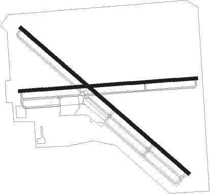
Safford - Safford Regl
Airport details
| Country | United States of America |
| State | Arizona |
| Region | K2 |
| Airspace | Albuquerque Ctr |
| Municipality | Safford |
| Elevation | 3174ft (967m) |
| Timezone | GMT -7 |
| Coordinates | 32.85016, -109.64108 |
| Magnetic var | |
| Type | land |
| Available since | X-Plane v10.40 |
| ICAO code | KSAD |
| IATA code | SAD |
| FAA code | SAD |
Communication
| Safford Regl ASOS | 124.175 |
| Safford Regl CTAF/UNICOM | 122.800 |
Nearby Points of Interest:
William Talley House
-Graham County Courthouse
-Point of Pines Sites
-Columbine Work Station
-Black Gap Bridge
-Clifton Townsite Historic District
-Benjamin F. Billingsley House
-Sierra Bonita Ranch

Nearby beacons
| code | identifier | dist | bearing | frequency |
|---|---|---|---|---|
| SSO | SAN SIMON VORTAC | 39.7 | 147° | 115.40 |
Departure and arrival routes
| Transition altitude | 18000ft |
| Transition level | 18000ft |
| SID end points | distance | outbound heading | |
|---|---|---|---|
| RW12 | |||
| SAFRD1 | 40mi | 147° | |
| RW30 | |||
| SAFRD1 | 40mi | 147° | |
Instrument approach procedures
| runway | airway (heading) | route (dist, bearing) |
|---|---|---|
| RW12 | DEPHE (72°) | DEPHE CIBBI (35mi, 43°) 9800ft BAXKU (10mi, 77°) 8100ft IPHIB (5mi, 130°) 7000ft |
| RW12 | SSO (327°) | SSO BAXKU (57mi, 322°) 8700ft BAXKU (turn) 8100ft IPHIB (5mi, 130°) 7000ft |
| RNAV | IPHIB 7000ft ARUJU (4mi, 130°) 5700ft WUGOD (4mi, 130°) 4480ft KSAD (4mi, 135°) 3204ft EBVOY (9mi, 128°) SSO (32mi, 152°) 10000ft SSO (turn) | |
| RW30 | SSO (327°) | SSO GEDZU (24mi, 341°) 7300ft FIMNU (4mi, 311°) 7200ft |
| RNAV | FIMNU 7200ft EBVOY (5mi, 311°) 5800ft ZUMMO (4mi, 311°) 4480ft KSAD (5mi, 307°) 3205ft ARUJU (8mi, 313°) CIBBI (17mi, 282°) DEPHE (35mi, 223°) 10000ft DEPHE (turn) |
Disclaimer
The information on this website is not for real aviation. Use this data with the X-Plane flight simulator only! Data taken with kind consent from X-Plane 12 source code and data files. Content is subject to change without notice.