San Luis Obispo - San Luis County Regl
Airport details
| Country | United States of America |
| State | California |
| Region | K2 |
| Airspace | Los Angeles Ctr |
| Municipality | San Luis Obispo County |
| Elevation | 211ft (64m) |
| Timezone | GMT -8 |
| Coordinates | 35.23742, -120.63679 |
| Magnetic var | |
| Type | land |
| Available since | X-Plane v10.40 |
| ICAO code | KSBP |
| IATA code | SBP |
| FAA code | SBP |
Communication
| San Luis County Regl ATIS | 120.600 |
| San Luis County Regl UNICOM | 122.950 |
| San Luis County Regl CTAF | 124.000 |
| San Luis County Regl SAN LUIS GROUND | 121.600 |
| San Luis County Regl SAN LUIS TOWER | 124.000 |
| San Luis County Regl L.A. CENTER APCH/Departure | 119.050 |
| San Luis County Regl SANTA BARBARA APCH/Departure | 127.725 |
Approach frequencies
| ILS-cat-I | RW11 | 109.7 | 18.00mi |
| 3° GS | RW11 | 109.7 | 18.00mi |
Nearby Points of Interest:
Tribune-Republic Building
-Pacific Coast Railway Company Grain Warehouse
-Myron Angel House
-San Luis Obispo Carnegie Library
-William Shipsey House
-The Powerhouse (San Luis Obispo, California)
-John Price House
-Arroyo Grande IOOF Hall
-Rancho Cañada de los Osos y Pecho y Islay
-Morro Rock
-Guadalupe-Nipomo Dunes National Wildlife Refuge
-Atascadero Administration Building
-Atascadero Printery
-Guadalupe-Nipomo Dunes
-Bank of Italy
-Vandenberg SFB Space Launch Complex 10
-Los Alamos Ranch House
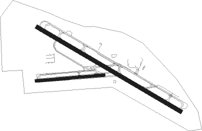
Runway info
Runway 11 / 29  | ||
| length | 1860m (6102ft) | |
| bearing | 120° / 300° | |
| width | 46m (150ft) | |
| surface | asphalt | |
| displ threshold | 244m (801ft) / 154m (505ft) | |
| blast zone | 181m (594ft) / 183m (600ft) | |
| Runway 7 / 25 | ||
| length | 763m (2503ft) | |
| bearing | 90° / 270° | |
| width | 30m (100ft) | |
| surface | asphalt | |
| blast zone | 0m (0ft) / 134m (440ft) | |
Nearby beacons
| code | identifier | dist | bearing | frequency |
|---|---|---|---|---|
| MQO | MORRO BAY (SAN LUIS OBISP VORTAC | 6 | 277° | 112.40 |
| GLJ | GUADALUPE (SANTA MARIA) VOR | 18 | 158° | 111 |
| PRB | PASO ROBLES VORTAC | 26.1 | 1° | 114.30 |
| VBG | VANDENBERG (LOMPOC) TACAN | 30.4 | 174° | 112.25 |
| FLW | FELLOWS VOR/DME | 38.8 | 101° | 117.50 |
| AVE | AVENAL VOR/DME | 40.5 | 58° | 117.10 |
| GVO | GAVIOTA VORTAC | 50.2 | 142° | 113.80 |
| HGT | HUNTER LIGGETT NDB | 51.1 | 323° | 209 |
| RZS | SAN MARCUS (SANTA BARBARA VORTAC | 61 | 130° | 114.90 |
Departure and arrival routes
| Transition altitude | 18000ft |
| Transition level | 18000ft |
| SID end points | distance | outbound heading | |
|---|---|---|---|
| RW11 | |||
| WYNNR4 | 61mi | 130° | |
| RW29 | |||
| CREPE3 | 26mi | 1° | |
Instrument approach procedures
| runway | airway (heading) | route (dist, bearing) |
|---|---|---|
| RW11 | CALIS (115°) | CALIS CREPE (8mi, 109°) 3400ft |
| RW11 | LOGVE (102°) | LOGVE CREPE (6mi, 60°) 3400ft |
| RW11 | PRB (181°) | PRB NACIN (17mi, 226°) 4300ft CREPE (6mi, 187°) 3400ft |
| RNAV | CREPE 3400ft JAMPO (6mi, 120°) 2400ft ZIRVA (3mi, 120°) 1280ft KSBP (4mi, 118°) 217ft (6882mi, 106°) 1000ft FABEG (6882mi, 286°) 4800ft FABEG (turn) 4800ft | |
| RW29 | FABEG (335°) | FABEG CADAB (8mi, 40°) 3900ft |
| RW29 | KIKII (221°) | KIKII CADAB (19mi, 176°) 5700ft CADAB (turn) 3900ft |
| RW29 | WYNNR (286°) | WYNNR CADAB (11mi, 271°) 3900ft |
| RNAV | CADAB 3900ft HALDA (4mi, 300°) 2900ft CAVLI (2mi, 300°) 2400ft WUTUB (3mi, 300°) 1220ft KSBP (3mi, 302°) 264ft (6882mi, 106°) 1100ft WUNUL (6893mi, 286°) 4100ft WUNUL (turn) 4100ft |
Disclaimer
The information on this website is not for real aviation. Use this data with the X-Plane flight simulator only! Data taken with kind consent from X-Plane 12 source code and data files. Content is subject to change without notice.