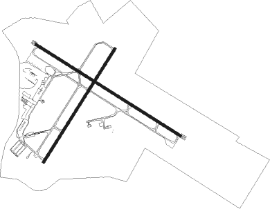
Salisbury - Salisbury Ocean City Wicomico Regional
Airport details
| Country | United States of America |
| State | Maryland |
| Region | K6 |
| Airspace | Washington Ctr |
| Municipality | Wicomico County |
| Elevation | 49ft (15m) |
| Timezone | GMT -5 |
| Coordinates | 38.34019, -75.50948 |
| Magnetic var | |
| Type | land |
| Available since | X-Plane v10.40 |
| ICAO code | KSBY |
| IATA code | SBY |
| FAA code | SBY |
Communication
| Salisbury Ocean City Wicomico Regional ASOS | 118.325 |
| Salisbury Ocean City Wicomico Regional CTAF | 119.425 |
| Salisbury Ocean City Wicomico Regional UNICOM | 122.950 |
| Salisbury Ocean City Wicomico Regional SALISBURY GROUND | 123.775 |
| Salisbury Ocean City Wicomico Regional SALISBURY TOWER | 119.425 |
| Salisbury Ocean City Wicomico Regional PATUXENT ApproachROACH | 127.200 |
| Salisbury Ocean City Wicomico Regional PATUXENT DepartureARTURE | 127.950 |
Approach frequencies
| ILS-cat-I | RW32 | 108.7 | 18.00mi |
| 3° GS | RW32 | 108.7 | 18.00mi |
Nearby Points of Interest:
Union Station
-Poplar Hill Mansion
-Perry-Cooper House
-Maude R. Toulson Federal Building
-F. Leonard Wailes Law Office
-Gillis-Grier House
-Sen. William P. Jackson House
-Asbury Methodist Episcopal Church
-Spring Hill Church
-St. Giles
-Stanley Potato House
-White Hall
-Bennett's Adventure
-George Washington Purnell House
-Samuel Gunn House
-Chanceford
-Governor John Walter Smith House
-Bounds Lott
-James Martin House
-Queponco Railway Station
-Princess Anne Historic District
-Catalpa Farm
-Beckford
-Simpson's Grove
-Ross Point School
Nearby beacons
| code | identifier | dist | bearing | frequency |
|---|---|---|---|---|
| SBY | SALISBURY VORTAC | 0.2 | 347° | 111.20 |
| OX | LANDY (OCEAN CITY) NDB | 14.7 | 86° | 407 |
| SWL | SNOW HILL VORTAC | 17.1 | 171° | 112.40 |
| ATR | WATERLOO VOR/DME | 31.4 | 32° | 112.60 |
| PXT | PATUXENT (PATUXENT RIVER) VORTAC | 42 | 267° | 117.60 |
| NHK | PATUXENT NDB | 42.2 | 267° | 400 |
| NHK | NAS PATUXENT RIVER TACAN | 42.6 | 266° | 110.25 |
| DOV | DOVER TACAN | 47.6 | 3° | 110 |
| ENO | SMYRNA (KENTON) VORTAC | 53.5 | 360° | 111.40 |
| SIE | SEA ISLE VORTAC | 56.2 | 43° | 114.80 |
| CCV | CAPE CHARLES VORTAC | 63.9 | 206° | 112.20 |
| MTN | MARTIN (BALTIMORE) TACAN | 72.9 | 318° | 134.10 |
Instrument approach procedures
| runway | airway (heading) | route (dist, bearing) |
|---|---|---|
| RW05 | MAGGO (32°) | MAGGO FEYKO (10mi, 14°) 2000ft |
| RW05 | SBY (167°) | SBY FEYKO (15mi, 223°) 2000ft FEYKO (turn) 2000ft |
| RNAV | FEYKO 2000ft EDITH (8mi, 43°) 2000ft ZAGID (3mi, 43°) 880ft KSBY (3mi, 45°) 83ft (4725mi, 117°) 341ft OKKOE (4720mi, 297°) 2000ft OKKOE (turn) | |
| RW14 | CHOPS (133°) | CHOPS ASMUW (14mi, 155°) 2100ft HYDRS (9mi, 120°) 2100ft |
| RW14 | EZIZI (180°) | EZIZI HYDRS (13mi, 233°) 2100ft HYDRS (turn) 2100ft |
| RW14 | SBY (167°) | SBY HYDRS (11mi, 300°) 2100ft HYDRS (turn) 2100ft |
| RNAV | HYDRS 2100ft EWWEL (6mi, 120°) 1700ft FIKLU (2mi, 120°) 940ft KSBY (3mi, 122°) 91ft (4725mi, 117°) 363ft FRYER (4714mi, 297°) 2000ft FRYER (turn) | |
| RW23 | EZIZI (180°) | EZIZI OKKOE (10mi, 128°) 2000ft |
| RW23 | SBY (167°) | SBY OKKOE (11mi, 44°) 2000ft OKKOE (turn) 2000ft |
| RNAV | OKKOE 2000ft NUTPY (6mi, 223°) 1700ft ZASBA (3mi, 223°) 600ft KSBY (2mi, 222°) 100ft (4725mi, 117°) 371ft FEYKO (4732mi, 297°) 2000ft FEYKO (turn) | |
| RW32 | SBY (167°) | SBY FRYER (13mi, 121°) 2000ft FRYER (turn) 2000ft |
| RW32 | SWL (351°) | SWL DOYSU (7mi, 48°) 2000ft FRYER (5mi, 43°) 2000ft |
| RNAV | FRYER 2000ft COLBE (6mi, 301°) 2000ft PUJKE (4mi, 300°) 740ft KSBY (3mi, 299°) 106ft (4725mi, 117°) 253ft HYDRS (4736mi, 297°) 2100ft HYDRS (turn) |
Disclaimer
The information on this website is not for real aviation. Use this data with the X-Plane flight simulator only! Data taken with kind consent from X-Plane 12 source code and data files. Content is subject to change without notice.

