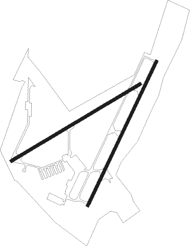
Suffolk - Suffolk Executive
Airport details
| Country | United States of America |
| State | Virginia |
| Region | K6 |
| Airspace | Washington Ctr |
| Municipality | Suffolk |
| Elevation | 70ft (21m) |
| Timezone | GMT -5 |
| Coordinates | 36.68289, -76.59962 |
| Magnetic var | |
| Type | land |
| Available since | X-Plane v10.40 |
| ICAO code | KSFQ |
| IATA code | n/a |
| FAA code | SFQ |
Communication
| Suffolk Executive AWOS 3 | 119.375 |
| Suffolk Executive CTAF/UNICOM | 122.700 |
| Suffolk Executive NORFOLK Approach/Departure | 127.900 |
Approach frequencies
| LOC | RW04 | 109.95 | 18.00mi |
Nearby beacons
| code | identifier | dist | bearing | frequency |
|---|---|---|---|---|
| OR | INGLE (NORFOLK) NDB | 19.2 | 66° | 329 |
| FKN | FRANKLIN VORTAC | 19.9 | 274° | 110.60 |
| NGU | CHAMBERS (NORFOLK) TACAN | 21.8 | 51° | 113.95 |
| NFE | CHESAPEAKE TACAN | 22.2 | 88° | 108.25 |
| CVI | COFIELD VORTAC | 22.7 | 221° | 114.60 |
| ORF | NORFOLK VORTAC | 22.9 | 62° | 116.90 |
| AKQ | WAKEFIELD NDB | 26.3 | 307° | 274 |
| LFI | LANGLEY (HAMPTON) TACAN | 26.7 | 31° | 112.30 |
| NTU | OCEANA TACAN | 28.3 | 76° | 116.60 |
| LLW | WOODVILLE (ELIZABETH CITY) NDB | 29.1 | 144° | 254 |
| ECG | ELIZABETH CITY VOR/DME | 32.7 | 135° | 112.50 |
| HPW | HOPEWELL VORTAC | 46 | 321° | 112 |
| HCM | HARCUM VORTAC | 46.3 | 352° | 108.80 |
| CCV | CAPE CHARLES VORTAC | 49.2 | 42° | 112.20 |
| RIC | RICHMOND VORTAC | 60.1 | 319° | 114.10 |
| RBX | WRIGHT BROTHERS (MANTEO) VOR/DME | 63.2 | 130° | 111.60 |
| MQI | MANTEO NDB | 63.5 | 130° | 370 |
| AQE | ALWOOD (GREENVILLE) NDB | 69.5 | 218° | 230 |
Departure and arrival routes
| Transition altitude | 18000ft |
| Transition level | 18000ft |
| STAR starting points | distance | inbound heading | |
|---|---|---|---|
| ALL | |||
| TERKS2 | 140.3 | 116° | |
Instrument approach procedures
| runway | airway (heading) | route (dist, bearing) |
|---|---|---|
| RW04 | CVI (41°) | CVI OLUCE (10mi, 49°) 2000ft |
| RW04 | OLUCE (35°) | OLUCE 6000ft OLUCE (turn) 2000ft |
| RW04 | ORF (242°) | ORF SUFSO (34mi, 216°) 2000ft OLUCE (10mi, 295°) 2000ft |
| RNAV | OLUCE 2000ft ZAXIB (7mi, 36°) 2000ft SIMLE (4mi, 36°) 680ft KSFQ (2mi, 33°) 111ft (4762mi, 116°) 600ft OLUCE (4767mi, 295°) 2000ft OLUCE (turn) | |
| RW07 | CVI (41°) | CVI LALSE (14mi, 16°) 2000ft |
| RW07 | LALSE (69°) | LALSE 2000ft |
| RNAV | LALSE 2000ft IDZAT (6mi, 68°) 1600ft WOPID (3mi, 68°) 680ft KSFQ (2mi, 70°) 108ft (4762mi, 116°) 470ft LALSE (4771mi, 295°) 2000ft LALSE (turn) | |
| RW22 | VEGHE (247°) | VEGHE ZAKEN (8mi, 290°) 2300ft |
| RNAV | ZAKEN 2300ft WOLIB (8mi, 216°) 1800ft JOVAM (3mi, 216°) 700ft KSFQ (2mi, 218°) 114ft (4762mi, 116°) 440ft OLUCE (4767mi, 295°) 2000ft OLUCE (turn) | |
| RW25 | ORF (242°) | ORF ZOTID (11mi, 236°) 2300ft |
| RW25 | ZOTID (248°) | ZOTID 2300ft |
| RNAV | ZOTID 2300ft WOVTI (7mi, 248°) 1800ft KSFQ (6mi, 247°) 107ft (4762mi, 116°) 470ft LALSE (4771mi, 295°) 2000ft LALSE (turn) |
Disclaimer
The information on this website is not for real aviation. Use this data with the X-Plane flight simulator only! Data taken with kind consent from X-Plane 12 source code and data files. Content is subject to change without notice.

