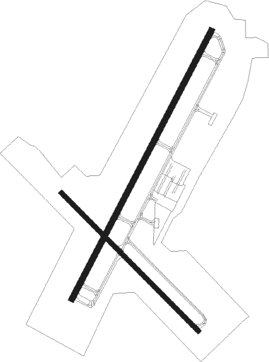
Pawtucket - North Central State
Airport details
| Country | United States of America |
| State | Rhode Island |
| Region | K6 |
| Airspace | Boston Ctr |
| Municipality | Smithfield |
| Elevation | 439ft (134m) |
| Timezone | GMT -5 |
| Coordinates | 41.92075, -71.49142 |
| Magnetic var | |
| Type | land |
| Available since | X-Plane v10.30 |
| ICAO code | KSFZ |
| IATA code | SFZ |
| FAA code | SFZ |
Communication
| North Central State AWOS 3 | 120.775 |
| North Central State Clearance DEL | 124.350 |
| North Central State CTAF/Unicom | 123.075 |
| North Central State PROVIDENCE Approach/Departure | 123.675 |
Approach frequencies
| LOC | RW05 | 111.9 | 18.00mi |
Nearby Points of Interest:
Angell-Ballou House
-Smith-Appleby House
-Jenckes House
-Ballou House
-Pullen Corner School
-Lime Kilns
-Whipple-Cullen House and Barn
-Daniel Angell House
-Allenville Mill
-Blackstone Canal, Rhode Island Segment
-Tyler Mowry House
-Old Ashton Historic District
-Ira B. Sweet House
-Smithfield Road Historic District
-Ashton Historic District
-Hearthside
-Lewis Tower House
-St. Joseph's Church Complex
-Israel Arnold House
-Luke Jillson House
-Great Road Historic District
-Eleazer Arnold House
-William Mowry House
-Edwin H. Farnum House
Nearby beacons
| code | identifier | dist | bearing | frequency |
|---|---|---|---|---|
| PVD | PROVIDENCE VOR/DME | 12.1 | 163° | 115.60 |
| PUT | PUTNAM VOR/DME | 15.8 | 276° | 117.40 |
| OW | STOGE (NORWOOD) NDB | 20.1 | 61° | 397 |
| ORW | NORWICH VOR/DME | 31.5 | 234° | 110 |
| BOS | BOSTON VOR/DME | 34.4 | 49° | 112.70 |
| GON | GROTON VOR/DME | 43.4 | 224° | 110.85 |
| GDM | GARDNER VOR/DME | 45.2 | 318° | 110.60 |
| SEY | SANDY POINT (BLOCK ISLAND VOR/DME | 45.4 | 186° | 117.80 |
| FMH | OTIS (FALMOUTH) TACAN | 46.4 | 105° | 115.80 |
| MVY | MARTHA'S VINEYARD VOR/DME | 50.4 | 121° | 114.50 |
| LWM | DME | 52.2 | 26° | 112.50 |
| MJ | FITZY (MANCHESTER) NDB | 56.6 | 358° | 209 |
| MHT | MANCHESTER VOR/DME | 57.1 | 7° | 114.40 |
| EEN | DME | 63.3 | 318° | 109.40 |
Departure and arrival routes
| Transition altitude | 18000ft |
| Transition level | 18000ft |
| STAR starting points | distance | inbound heading | |
|---|---|---|---|
| ALL | |||
| WIPOR3 | 34.5 | 69° | |
Instrument approach procedures
| runway | airway (heading) | route (dist, bearing) |
|---|---|---|
| RW05 | EGAKE (65°) | EGAKE WALLU (7mi, 107°) 2600ft |
| RW05 | JEWIT (56°) | JEWIT WALLU (9mi, 76°) 2600ft |
| RW05 | ORW (54°) | ORW WALLU (20mi, 62°) 2600ft |
| RW05 | YBERA (7°) | YBERA WALLU (8mi, 312°) 2600ft |
| RNAV | WALLU 2600ft MIMIC (6mi, 40°) 2500ft IDIKE (3mi, 40°) 1420ft KSFZ (3mi, 41°) 471ft (4585mi, 120°) 2000ft FOSTY (4590mi, 300°) 2500ft FOSTY (turn) | |
| RW23 | BOS (229°) | BOS KENPY (22mi, 234°) 2500ft |
| RW23 | BURDY (266°) | BURDY KENPY (19mi, 290°) 2500ft |
| RW23 | WHYBE (193°) | WHYBE KENPY (10mi, 154°) 2500ft |
| RNAV | KENPY 2500ft RUSEL (6mi, 220°) 2300ft LIVGE (3mi, 220°) 1400ft KSFZ (4mi, 219°) 454ft (4585mi, 120°) 669ft WALLU (4589mi, 300°) 2600ft WALLU (turn) |
Disclaimer
The information on this website is not for real aviation. Use this data with the X-Plane flight simulator only! Data taken with kind consent from X-Plane 12 source code and data files. Content is subject to change without notice.

