St Johns - St Johns Industrial Air Park
Airport details
| Country | United States of America |
| State | Arizona |
| Region | K2 |
| Airspace | Albuquerque Ctr |
| Municipality | St. Johns |
| Elevation | 5733ft (1747m) |
| Timezone | GMT -7 |
| Coordinates | 34.51855, -109.37875 |
| Magnetic var | |
| Type | land |
| Available since | X-Plane v10.40 |
| ICAO code | KSJN |
| IATA code | SJN |
| FAA code | SJN |
Communication
| St Johns Industrial Air Park ASOS | 134.225 |
| St Johns Industrial Air Park CTAF/UNICOM | 122.800 |
| St Johns Industrial Air Park Albuquerque Ctr | 124.325 |
Nearby Points of Interest:
Isaacson Building
-Casa Malpaís
-Colter Ranch Historic District
-Eagar Townsite Historic District
-Lake Mountain Lookout Complex
-Hawikuh Ruins
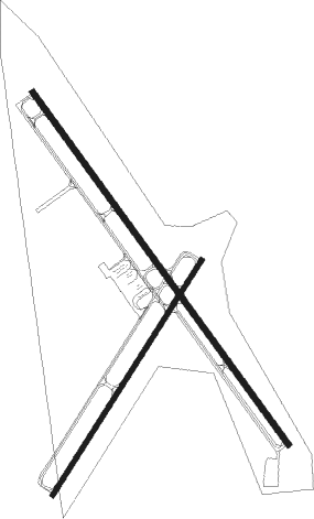
Runway info
Runway 14 / 32  | ||
| length | 1624m (5328ft) | |
| bearing | 143° / 323° | |
| width | 23m (75ft) | |
| surface | asphalt | |
| displ threshold | 0m (0ft) / 28m (92ft) | |
| Runway 3 / 21 | ||
| length | 1037m (3402ft) | |
| bearing | 42° / 222° | |
| width | 18m (60ft) | |
| surface | asphalt | |
| displ threshold | 58m (190ft) / 0m (0ft) | |
Nearby beacons
| code | identifier | dist | bearing | frequency |
|---|---|---|---|---|
| SJN | ST JOHNS VORTAC | 12.9 | 112° | 112.30 |
| ZUN | ZUNI VORTAC | 29 | 27° | 113.40 |
| GUP | GALLUP VORTAC | 62.6 | 28° | 115.10 |
Instrument approach procedures
| runway | airway (heading) | route (dist, bearing) |
|---|---|---|
| RW14 | DEHOG (79°) | DEHOG IRECU (21mi, 50°) 8900ft CAPEP (11mi, 81°) 8300ft |
| RNAV | CAPEP 8300ft DIGAY (6mi, 143°) 7300ft KSJN (5mi, 144°) 5774ft (6358mi, 108°) 6137ft ZERIG (6357mi, 288°) SJN (11mi, 107°) 9000ft SJN (turn) | |
| RW32 | IRECU (111°) | IRECU GUVCE (29mi, 123°) 9400ft GUVCE (turn) 9400ft |
| RW32 | SJN (292°) | SJN GUVCE (7mi, 234°) 9400ft GUVCE (turn) 9400ft |
| RNAV | GUVCE 9400ft HOXOK (3mi, 323°) 8500ft CUVOV (3mi, 323°) 7700ft HUGOV (4mi, 323°) 6480ft KSJN (2mi, 322°) 5790ft (6358mi, 108°) 5987ft ZOVEK (6359mi, 288°) IRECU (16mi, 285°) 9400ft IRECU (turn) |
Disclaimer
The information on this website is not for real aviation. Use this data with the X-Plane flight simulator only! Data taken with kind consent from X-Plane 12 source code and data files. Content is subject to change without notice.