Taos - Taos Regl
Airport details
| Country | United States of America |
| State | New Mexico |
| Region | K2 |
| Airspace | Albuquerque Ctr |
| Municipality | Taos County |
| Elevation | 7087ft (2160m) |
| Timezone | GMT -7 |
| Coordinates | 36.45817, -105.67242 |
| Magnetic var | |
| Type | land |
| Available since | X-Plane v10.40 |
| ICAO code | KSKX |
| IATA code | TSM |
| FAA code | SKX |
Communication
| Taos Regl AWOS 3 | 132.975 |
| Taos Regl CTAF/UNICOM | 122.800 |
Nearby Points of Interest:
Rio Grande Gorge Bridge
-La Loma Plaza Historic District
-Taos Downtown Historic District
-Eanger Irving Couse House and Studio—Joseph Henry Sharp Studios
-Mabel Dodge Luhan House
-La Morada de Nuestra Senora de Guadalupe
-E. Martin Hennings House and Studio Historic District
-Leon Gaspard House
-Ranchos de Taos Plaza
-Carson School
-D. H. Lawrence Ranch
-Embudo
-Las Trampas
-San José de Gracia Church
-Ojo Caliente Hot Springs Round Barn
-Posi-ouinge
-Embudo Stream Gauging Station
-Eagle Nest Dam
-Tsama Pueblo
-San Gabriel de Yungue-Ouinge
-Rio Grande Bridge at San Juan Pueblo
-Daniel Cassidy and Sons General Merchandise Store
-Cassidy Mill
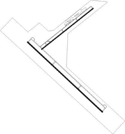
Runway info
Runway 13 / 31  | ||
| length | 2621m (8599ft) | |
| bearing | 131° / 311° | |
| width | 30m (100ft) | |
| surface | asphalt | |
| blast zone | 46m (151ft) / 46m (151ft) | |
| Runway 4 / 22 | ||
| length | 1676m (5499ft) | |
| bearing | 62° / 242° | |
| width | 23m (75ft) | |
| surface | asphalt | |
| blast zone | 46m (151ft) / 76m (249ft) | |
Nearby beacons
| code | identifier | dist | bearing | frequency |
|---|---|---|---|---|
| TAS | TAOS VORTAC | 14.4 | 303° | 117.60 |
| CIM | CIMARRON VORTAC | 38.7 | 88° | 116.40 |
| ALS | ALAMOSA VORTAC | 53.9 | 351° | 113.90 |
| FTI | FORT UNION VORTAC | 54.6 | 146° | 117.30 |
| SAF | SANTA FE VORTAC | 58.3 | 203° | 110.60 |
Instrument approach procedures
| runway | airway (heading) | route (dist, bearing) |
|---|---|---|
| RW04 | DIXAN (58°) | DIXAN WOMPI (5mi, 49°) 9800ft |
| RW04 | TELOY (78°) | TELOY WOMPI (4mi, 140°) 9800ft |
| RNAV | WOMPI 9800ft JAXAR (6mi, 61°) 9000ft DOYDE (3mi, 61°) 8020ft KSKX (3mi, 62°) 7092ft (6159mi, 109°) 7480ft TELOY (6172mi, 289°) 11000ft TELOY (turn) | |
| RW13 | TELOY (78°) | TELOY OQUDI (13mi, 21°) 11000ft OQUDI (turn) 11000ft |
| RW13 | ZOTOS (161°) | ZOTOS OQUDI (23mi, 180°) 11000ft |
| RNAV | OQUDI 11000ft UJZIN (6mi, 131°) 9000ft WORIN (3mi, 131°) 8060ft KSKX (3mi, 123°) 7084ft (6159mi, 109°) 7800ft OQUDI (6166mi, 289°) 12400ft OQUDI (turn) |
Disclaimer
The information on this website is not for real aviation. Use this data with the X-Plane flight simulator only! Data taken with kind consent from X-Plane 12 source code and data files. Content is subject to change without notice.