Santa Maria - Santa Maria / A. Hancock Field
Airport details
| Country | United States of America |
| State | California |
| Region | K2 |
| Airspace | Los Angeles Ctr |
| Municipality | Santa Maria |
| Elevation | 261ft (80m) |
| Timezone | GMT -8 |
| Coordinates | 34.89214, -120.45449 |
| Magnetic var | |
| Type | land |
| Available since | X-Plane v10.40 |
| ICAO code | KSMX |
| IATA code | SMX |
| FAA code | SMX |
Communication
| Santa Maria / A. Hancock Field ATIS | 121.150 |
| Santa Maria / A. Hancock Field CTAF | 118.300 |
| Santa Maria / A. Hancock Field UNICOM | 122.950 |
| Santa Maria / A. Hancock Field Ground Control | 121.900 |
| Santa Maria / A. Hancock Field Tower | 118.300 |
| Santa Maria / A. Hancock Field SANTA BARB Approach/Departure | 124.150 |
Approach frequencies
| ILS-cat-I | RW12 | 108.9 | 18.00mi |
| 3° GS | RW12 | 108.9 | 18.00mi |
Nearby Points of Interest:
Guadalupe-Nipomo Dunes National Wildlife Refuge
-Los Alamos Ranch House
-Guadalupe-Nipomo Dunes
-Vandenberg SFB Space Launch Complex 10
-Arroyo Grande IOOF Hall
-John Price House
-Tribune-Republic Building
-Pacific Coast Railway Company Grain Warehouse
-Myron Angel House
-San Luis Obispo Carnegie Library
-William Shipsey House
-The Powerhouse (San Luis Obispo, California)
-Gaviota Pass
-Rancho Cañada de los Osos y Pecho y Islay
Runway info
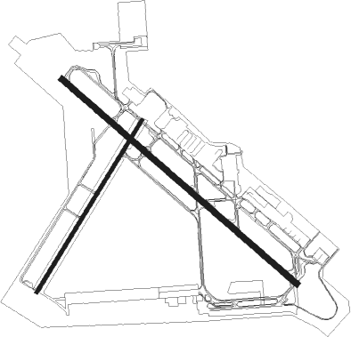
Runway 12 / 30  | ||
| length | 2442m (8012ft) | |
| bearing | 130° / 310° | |
| width | 46m (151ft) | |
| surface | asphalt | |
| blast zone | 67m (220ft) / 0m (0ft) | |
| Runway 2 / 20 | ||
| length | 1583m (5194ft) | |
| bearing | 41° / 221° | |
| width | 23m (75ft) | |
| surface | asphalt | |
Nearby beacons
| code | identifier | dist | bearing | frequency |
|---|---|---|---|---|
| GLJ | GUADALUPE (SANTA MARIA) VOR | 4.8 | 312° | 111 |
| VBG | VANDENBERG (LOMPOC) TACAN | 11.4 | 219° | 112.25 |
| MQO | MORRO BAY (SAN LUIS OBISP VORTAC | 26.3 | 320° | 112.40 |
| GVO | GAVIOTA VORTAC | 28.1 | 135° | 113.80 |
| FLW | FELLOWS VOR/DME | 31.3 | 71° | 117.50 |
| RZS | SAN MARCUS (SANTA BARBARA VORTAC | 40.8 | 119° | 114.90 |
| PRB | PASO ROBLES VORTAC | 47.6 | 348° | 114.30 |
| AVE | AVENAL VOR/DME | 50.9 | 32° | 117.10 |
Departure and arrival routes
| Transition altitude | 18000ft |
| Transition level | 18000ft |
| SID end points | distance | outbound heading | |
|---|---|---|---|
| RW02 | |||
| BUELT4 | 41mi | 119° | |
| RW12 | |||
| BUELT4 | 41mi | 119° | |
| RW30 | |||
| BUELT4 | 41mi | 119° | |
Instrument approach procedures
| runway | airway (heading) | route (dist, bearing) |
|---|---|---|
| RW12 | MQO (140°) | MQO WINCH (12mi, 152°) 3300ft |
| RW12 | ORCUT (300°) | ORCUT WINCH (19mi, 309°) 3300ft WINCH (turn) 3300ft |
| RNAV | WINCH 3300ft DEMFA (8mi, 130°) 2000ft KSMX (6mi, 133°) 272ft (6881mi, 106°) 800ft MQO (6888mi, 286°) 5000ft MQO (turn) | |
| RW30 | GVO (315°) | GVO NIRLE (8mi, 309°) 4400ft ELZUS (8mi, 309°) 3500ft PAMJI (4mi, 326°) 2500ft |
| RNAV | PAMJI 2500ft CIMSO (3mi, 326°) 2200ft ANIBY (1mi, 326°) 1780ft KSMX (4mi, 320°) 311ft (6881mi, 106°) 661ft HANNU (6881mi, 286°) WINCH (10mi, 303°) 4000ft WINCH (turn) |
Disclaimer
The information on this website is not for real aviation. Use this data with the X-Plane flight simulator only! Data taken with kind consent from X-Plane 12 source code and data files. Content is subject to change without notice.