Show Low
Airport details
| Country | United States of America |
| State | Arizona |
| Region | K2 |
| Airspace | Albuquerque Ctr |
| Municipality | Show Low |
| Elevation | 6415ft (1955m) |
| Timezone | GMT -7 |
| Coordinates | 34.26411, -110.00826 |
| Magnetic var | |
| Type | land |
| Available since | X-Plane v10.40 |
| ICAO code | KSOW |
| IATA code | SOW |
| FAA code | SOW |
Communication
| Show Low AWOS-3 | 118.075 |
| Show Low SHOW LOW CTAF/UNICOM | 123.000 |
Nearby Points of Interest:
Corduroy Creek Bridge
-Lake Mountain Lookout Complex
-Cedar Canyon Bridge
-Kinishba Ruins
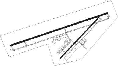
Runway info
Runway 7 / 25  | ||
| length | 2189m (7182ft) | |
| bearing | 78° / 258° | |
| width | 30m (100ft) | |
| surface | asphalt | |
| displ threshold | 213m (699ft) / 0m (0ft) | |
| Runway 4 / 22 | ||
| length | 1202m (3944ft) | |
| bearing | 53° / 233° | |
| width | 18m (60ft) | |
| surface | asphalt | |
Nearby beacons
| code | identifier | dist | bearing | frequency |
|---|---|---|---|---|
| SJN | ST JOHNS VORTAC | 43.9 | 80° | 112.30 |
| ZUN | ZUNI VORTAC | 59.6 | 51° | 113.40 |
| INW | WINSLOW VORTAC | 61.6 | 315° | 112.60 |
Instrument approach procedures
| runway | airway (heading) | route (dist, bearing) |
|---|---|---|
| RW25 | DEHOG (178°) | DEHOG JASUR (13mi, 107°) 9700ft JASUR (turn) 9700ft |
| RW25 | SJN (260°) | SJN JASUR (32mi, 260°) 9700ft |
| RW25 | WEKUM (49°) | WEKUM JASUR (29mi, 61°) 9700ft JASUR (turn) 9700ft |
| RNAV | JASUR 9700ft POBUE (4mi, 258°) 8700ft CUBOL (2mi, 258°) 8200ft HEVAM (2mi, 258°) 7400ft KSOW (4mi, 257°) 6451ft (6392mi, 107°) 6605ft ZAXIN (6396mi, 287°) WEKUM (15mi, 219°) 13000ft WEKUM (turn) |
Disclaimer
The information on this website is not for real aviation. Use this data with the X-Plane flight simulator only! Data taken with kind consent from X-Plane 12 source code and data files. Content is subject to change without notice.