Springfield - Abraham Lincoln Capital
Airport details
| Country | United States of America |
| State | Illinois |
| Region | K5 |
| Airspace | Kansas City Ctr |
| Municipality | Springfield |
| Elevation | 597ft (182m) |
| Timezone | GMT -6 |
| Coordinates | 39.84422, -89.67809 |
| Magnetic var | |
| Type | land |
| Available since | X-Plane v10.30 |
| ICAO code | KSPI |
| IATA code | SPI |
| FAA code | SPI |
Communication
| Abraham Lincoln Capital ATIS | 127.650 |
| Abraham Lincoln Capital UNICOM | 122.950 |
| Abraham Lincoln Capital CTAF | 121.300 |
| Abraham Lincoln Capital Clearance DEL | 121.700 |
| Abraham Lincoln Capital Ground Control | 121.900 |
| Abraham Lincoln Capital SPRINGFIELD Tower | 121.300 |
| Abraham Lincoln Capital SPRINGFIELD Approach/Departure | 118.600 |
| Abraham Lincoln Capital SPRINGFIELD Approach/Departure | 126.150 |
Approach frequencies
| ILS-cat-I | RW31 | 110.15 | 18.00mi |
| ILS-cat-I | RW22 | 111.7 | 18.00mi |
| ILS-cat-I | RW04 | 109.5 | 18.00mi |
| 3° GS | RW31 | 110.15 | 18.00mi |
| 3° GS | RW22 | 111.7 | 18.00mi |
| 3° GS | RW04 | 109.5 | 18.00mi |
Nearby Points of Interest:
Camp Lincoln Commissary Building
-George M. Brinkerhoff House
-Rippon-Kinsella House
-John F. Bretz House and Warehouse
-Edwards Place
-Clarkson W. Freeman House
-Fisher Building-Latham Block
-Fred Gottschalk Grocery Store
-John L. Lewis House
-Jennings Ford Automobile Dealership
-Virgil Hickox House
-Illinois Executive Mansion
-Cong. James M. Graham House
-Lincoln Depot
-Hickox Apartments
-Gov. Richard Yates House
-Price/Wheeler House
-Bell Miller Apartments
-Howard K. Weber House
-Town House
-Heimberger House
-Bressmer-Baker House
-Dr. Charles Compton House
-H. P. Boult House
-Taylor Apartments
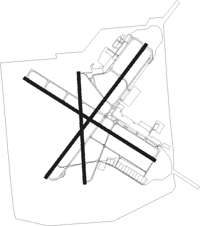
Runway info
Runway 4 / 22  | ||
| length | 2439m (8002ft) | |
| bearing | 49° / 229° | |
| width | 46m (150ft) | |
| surface | concrete | |
| blast zone | 255m (837ft) / 46m (151ft) | |
| Runway 13 / 31 | ||
| length | 2253m (7392ft) | |
| bearing | 120° / 300° | |
| width | 46m (150ft) | |
| surface | asphalt | |
| blast zone | 183m (600ft) / 61m (200ft) | |
| Runway 18 / 36 | ||
| length | 1618m (5308ft) | |
| bearing | 182° / 2° | |
| width | 46m (150ft) | |
| surface | asphalt | |
Nearby beacons
| code | identifier | dist | bearing | frequency |
|---|---|---|---|---|
| SPI | SPINNER (SPRINGFIELD) VORTAC | 0.2 | 176° | 112.70 |
| CJ | CALDE (SPRINGFIELD) NDB | 4.9 | 120° | 240 |
| LQ | LICOL (SPRINGFIELD) NDB | 5.3 | 48° | 375 |
| SP | HUSKK (SPRINGFIELD) NDB | 5.6 | 229° | 382 |
| AAA | ABRAHAM (LINCOLN) NDB | 24.5 | 47° | 329 |
| IJX | DME | 26.1 | 263° | 108.60 |
| DE | ELWIN (DECATUR) NDB | 33.5 | 94° | 275 |
| AXC | ADDERS VORTAC | 38.4 | 97° | 117.20 |
| PI | TUNGG (PEORIA) NDB | 45.8 | 6° | 356 |
| SYZ | SHELBYVILLE NDB | 46.7 | 118° | 365 |
| PIA | PEORIA VORTAC | 50.4 | 352° | 115.20 |
| VLA | VANDALIA VOR/DME | 51 | 145° | 114.30 |
| BMI | BLOOMINGTON VOR/DME | 51.3 | 50° | 108.20 |
| LH | EGROW (BLOOMINGTON-NORMAL) NDB | 56.6 | 48° | 334 |
| JZY | MACOMB NDB | 57.2 | 307° | 251 |
| CVM | CIVIC MEMORIAL (ALTON) NDB | 59.8 | 202° | 263 |
| STL | SAINT LOUIS VORTAC | 69.8 | 219° | 117.40 |
| PNT | PONTIAC VOR/DME | 72.8 | 44° | 109.60 |
Instrument approach procedures
| runway | airway (heading) | route (dist, bearing) |
|---|---|---|
| RW04 | AUBUR (12°) | AUBUR COVAC (12mi, 328°) 2700ft |
| RW04 | COVAC (49°) | COVAC 2700ft |
| RW04 | GINIA (90°) | GINIA COVAC (15mi, 123°) 2700ft |
| RNAV | COVAC 2700ft ZANRA (7mi, 49°) 2300ft KSPI (6mi, 49°) 644ft (5390mi, 114°) 854ft REYCO (5383mi, 294°) 2600ft REYCO (turn) | |
| RW13 | ATTIC (125°) | ATTIC JOPOD (7mi, 134°) 2500ft |
| RW13 | GINIA (90°) | GINIA JOPOD (12mi, 63°) 2500ft |
| RW13 | JOPOD (120°) | JOPOD 2500ft |
| RNAV | JOPOD 2500ft HIPLO (6mi, 120°) 2200ft TIPUW (2mi, 120°) 1520ft KSPI (3mi, 120°) 638ft CONOX (14mi, 120°) 3100ft CONOX (turn) | |
| RW22 | LASKK (248°) | LASKK REYCO (11mi, 265°) 2600ft |
| RW22 | LOTTO (172°) | LOTTO REYCO (21mi, 143°) 2600ft |
| RW22 | REYCO (229°) | REYCO 2600ft |
| RNAV | REYCO 2600ft DETLE (6mi, 229°) 2200ft KSPI (6mi, 229°) 652ft (5390mi, 114°) 883ft COVAC (5399mi, 294°) 2700ft COVAC (turn) | |
| RW31 | CLEEK (325°) | CLEEK CONOX (13mi, 0°) 3100ft |
| RW31 | CONOX (300°) | CONOX 3100ft |
| RW31 | LATHA (278°) | LATHA CONOX (11mi, 251°) 3100ft |
| RNAV | CONOX 3100ft WOPEX (9mi, 300°) 2100ft KSPI (5mi, 300°) 638ft (5390mi, 114°) 840ft JOPOD (5400mi, 294°) 2500ft JOPOD (turn) |
Disclaimer
The information on this website is not for real aviation. Use this data with the X-Plane flight simulator only! Data taken with kind consent from X-Plane 12 source code and data files. Content is subject to change without notice.