San Antonio - Stinson Municipal
Airport details
| Country | United States of America |
| State | Texas |
| Region | K4 |
| Airspace | Houston Oceanic Ctr |
| Municipality | San Antonio |
| Elevation | 577ft (176m) |
| Timezone | GMT -5 |
| Coordinates | 29.33698, -98.47105 |
| Magnetic var | |
| Type | land |
| Available since | X-Plane v10.40 |
| ICAO code | KSSF |
| IATA code | SSF |
| FAA code | KSSF |
Communication
| Stinson Municipal ATIS | 128.800 |
| Stinson Municipal CTAF | 118.200 |
| Stinson Municipal UNICOM | 122.950 |
| Stinson Municipal Ground Control/ Clearance DEL | 121.700 |
| Stinson Municipal Tower | 118.200 |
| Stinson Municipal SAN ANTONIO Approach/Departure | 125.700 |
Nearby Points of Interest:
Stinson Municipal Airport
-Hangar 9, Brooks Air Force Base
-Ethel Wilson Harris House
-Yturri-Edmunds House
-Anton Wulff House
-Alamo Methodist Church
-Monastery of Our Lady of Charity
-Otto Bombach House
-Acequia Madre de Valero
-Bexar County Courthouse
-Alamo Plaza Historic District
-Main and Military Plazas Historic District
-Johann and Anna Heidgen House
-Jeremiah Dashiell House
-Hipolito F. Garcia Federal Building and United States Courthouse
-Prospect Hill Missionary Baptist Church
-Aurora Apartment Hotel
-David J. and May Bock Woodward House
-San Antonio Military Medical Center
-Fort Sam Houston
-Fence at Alamo Cement Company
-Randolph Field Historic District
-Administration Building
-State Highway 3-A Bridge at Cibolo Creek
-Castroville Historic District
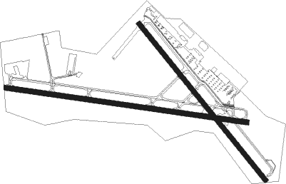
Runway info
Runway 9 / 27  | ||
| length | 1526m (5007ft) | |
| bearing | 101° / 281° | |
| width | 30m (100ft) | |
| surface | asphalt | |
| displ threshold | 137m (449ft) / 0m (0ft) | |
| blast zone | 0m (0ft) / 42m (138ft) | |
| Runway 14 / 32 | ||
| length | 1260m (4134ft) | |
| bearing | 142° / 322° | |
| width | 30m (100ft) | |
| surface | asphalt | |
| displ threshold | 181m (594ft) / 117m (384ft) | |
Nearby beacons
| code | identifier | dist | bearing | frequency |
|---|---|---|---|---|
| SSF | STINSON (SAN ANTONIO) VOR | 4.9 | 161° | 108.40 |
| KSY | KELLY (SAN ANTONIO) TACAN | 6.6 | 296° | 112 |
| RND | RANDOLPH VORTAC | 14.6 | 46° | 112.30 |
| DHK | RANDOLPH TACAN | 16 | 45° | 109.90 |
| AN | ALAMO (SAN ANTONIO) NDB | 17 | 340° | 368 |
| SAT | SAN ANTONIO VORTAC | 18.4 | 2° | 116.80 |
| HHH | DEVINE NDB | 27.2 | 247° | 359 |
| RU | GARYS (AUSTIN) NDB | 46.2 | 40° | 272 |
| CSI | CENTER POINT (KERRVILLE) VORTAC | 52.3 | 308° | 117.50 |
| THX | THREE RIVERS VORTAC | 52.7 | 159° | 111.40 |
| STV | STONEWALL VORTAC | 53.6 | 345° | 113.80 |
| COT | COTULLA VORTAC | 62.6 | 217° | 115.80 |
Departure and arrival routes
| Transition altitude | 18000ft |
| Transition level | 18000ft |
| SID end points | distance | outbound heading | |
|---|---|---|---|
| ALL | |||
| ALAMO3 | 133mi | 8° | |
| THX4 | 102mi | 144° | |
| BOWIE7, MILET4 | 122mi | 207° | |
| LEJON4 | 58mi | 320° | |
| STAR starting points | distance | inbound heading | |
|---|---|---|---|
| ALL | |||
| LEMIG1 | 21.6 | 5° | |
| CSI2 | 52.3 | 128° | |
| STV1 | 53.6 | 165° | |
| BRAUN3, MARCS1 | 46.3 | 227° | |
Instrument approach procedures
| runway | airway (heading) | route (dist, bearing) |
|---|---|---|
| RW32 | BRAUN (221°) | BRAUN JABLO (40mi, 200°) 3100ft GANLE (5mi, 252°) 2500ft |
| RW32 | GANLE (336°) | GANLE 6000ft GANLE (turn) 2500ft |
| RW32 | LEMIG (5°) | LEMIG HALKE (9mi, 9°) 3000ft GANLE (5mi, 72°) 2500ft |
| RW32 | SOMER (44°) | SOMER HALKE (9mi, 104°) 3000ft GANLE (5mi, 72°) 2500ft |
| RNAV | GANLE 2500ft FELMA (6mi, 337°) 2500ft KSSF (6mi, 335°) 596ft (5848mi, 107°) 977ft KONLE (5850mi, 287°) KICED (29mi, 294°) 4100ft KICED (turn) |
Holding patterns
| STAR name | hold at | type | turn | heading* | altitude | leg | speed limit |
|---|---|---|---|---|---|---|---|
| CSI2 | CSI | NDB | left | 280 (100)° | 1.0min timed | ICAO rules | |
| LEMIG1 | LEMIG | VHF | right | 175 (355)° | < 17999ft | 1.0min timed | ICAO rules |
| MARCS1 | CRAYS | VHF | right | 79 (259)° | < 17999ft | 1.0min timed | ICAO rules |
| *) magnetic outbound (inbound) holding course | |||||||
Disclaimer
The information on this website is not for real aviation. Use this data with the X-Plane flight simulator only! Data taken with kind consent from X-Plane 12 source code and data files. Content is subject to change without notice.