Brunswick - Malcolm Mckinnon Stsimons Is.
Airport details
| Country | United States of America |
| State | Georgia |
| Region | K7 |
| Airspace | Jacksonville Ctr |
| Municipality | Glynn County |
| Elevation | 19ft (6m) |
| Timezone | GMT -5 |
| Coordinates | 31.15197, -81.39105 |
| Magnetic var | |
| Type | land |
| Available since | X-Plane v10.40 |
| ICAO code | KSSI |
| IATA code | SSI |
| FAA code | SSI |
Communication
| Malcolm McKinnon StSimons Is. ASOS | 120.025 |
| Malcolm McKinnon StSimons Is. CTAF/UNICOM | 123.050 |
Nearby Points of Interest:
Strachan House Garage
-St. Simons Island Light
-Horton House Historic Site
-Frank M. Scarlett Federal Building
-Old Glynn County Courthouse
-Faith Chapel
-jekyll island club resort
-Rockefeller Cottage
-Hofwyl-Broadfield Plantation
-West Darien Historic District
-The Ridge Historic District
-Sapelo Island Range Front Light
-Old Camden County Courthouse
-Woodbine Historic District
-Sylvester Mumford House
-Fort Barrington
-St. Marys Historic District
-Orange Hall
-John Denham Palmer House
-Fernandina Beach Historic District
-Merrick-Simmons House
-Fairbanks House
-Bailey House
-Tabby House
-Brantley County Courthouse
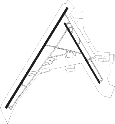
Runway info
Runway 4 / 22  | ||
| length | 1707m (5600ft) | |
| bearing | 40° / 220° | |
| width | 30m (100ft) | |
| surface | asphalt | |
| displ threshold | 238m (781ft) / 278m (912ft) | |
| blast zone | 67m (220ft) / 33m (108ft) | |
| Runway 16 / 34 | ||
| length | 1012m (3320ft) | |
| bearing | 151° / 331° | |
| width | 23m (75ft) | |
| surface | asphalt | |
| blast zone | 75m (246ft) / 76m (249ft) | |
Nearby beacons
| code | identifier | dist | bearing | frequency |
|---|---|---|---|---|
| SSI | BRUNSWICK (ST SIMONS I) VORTAC | 6.7 | 208° | 109.80 |
| MOQ | MC INTOSH (HINESVILLE) NDB | 41.2 | 350° | 263 |
| NRB | MAYPORT TACAN | 45.8 | 182° | 111.40 |
| JA | DINNS (JACKSONVILLE) NDB | 46.3 | 211° | 344 |
| CRG | CRAIG (JACKSONVILLE) VORTAC | 49.2 | 188° | 114.50 |
| SVN | HUNTER (SAVANNAH) VOR/DME | 53.2 | 16° | 111.60 |
| SV | WASSA (SAVANNAH) NDB | 55.2 | 25° | 335 |
| NIP | JACKSONVILLE TACAN | 56.9 | 197° | 108.20 |
| SAV | SAVANNAH VORTAC | 60.5 | 11° | 115.95 |
| NZC | CECIL TACAN | 61.1 | 207° | 114.10 |
| BHC | BAXLEY NDB | 61.2 | 299° | 376 |
Instrument approach procedures
| runway | airway (heading) | route (dist, bearing) |
|---|---|---|
| RW04 | FODEX (13°) | FODEX VIXRY (5mi, 302°) 2000ft |
| RW04 | HETOP (66°) | HETOP VIXRY (5mi, 122°) 2000ft |
| RW04 | VIXRY (41°) | VIXRY 2000ft |
| RNAV | VIXRY 2000ft YATGY (5mi, 40°) 1600ft KSSI (5mi, 41°) 48ft (4963mi, 111°) 419ft RIYSA (4958mi, 291°) 2000ft RIYSA (turn) | |
| RW22 | NUSIE (245°) | NUSIE RIYSA (5mi, 302°) 2000ft |
| RW22 | RIYSA (220°) | RIYSA 2000ft |
| RW22 | WALMO (191°) | WALMO RIYSA (5mi, 122°) 2000ft |
| RNAV | RIYSA 2000ft KAXFY (5mi, 220°) 1600ft KSSI (5mi, 219°) 71ft (4963mi, 111°) 419ft VIXRY (4969mi, 291°) 2000ft VIXRY (turn) |
Disclaimer
The information on this website is not for real aviation. Use this data with the X-Plane flight simulator only! Data taken with kind consent from X-Plane 12 source code and data files. Content is subject to change without notice.