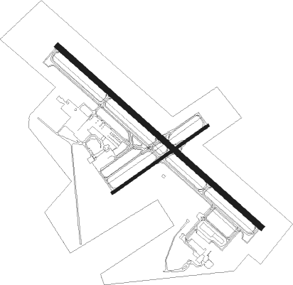
St Cloud - St Cloud Regl
Airport details
| Country | United States of America |
| State | Minnesota |
| Region | K3 |
| Airspace | Minneapolis Ctr |
| Municipality | St. Cloud |
| Elevation | 1028ft (313m) |
| Timezone | GMT -6 |
| Coordinates | 45.54655, -94.05989 |
| Magnetic var | |
| Type | land |
| Available since | X-Plane v10.40 |
| ICAO code | KSTC |
| IATA code | STC |
| FAA code | STC |
Communication
| St Cloud Regl ATIS | 119.375 |
| St Cloud Regl Ground Control | 123.750 |
| St Cloud Regl Tower | 118.250 |
Approach frequencies
| ILS-cat-I | RW13 | 111.9 | 18.00mi |
| ILS-cat-I | RW31 | 111.9 | 18.00mi |
| 3° GS | RW13 | 111.9 | 18.00mi |
| 3° GS | RW31 | 111.9 | 18.00mi |
Nearby Points of Interest:
Minnesota Correctional Facility – St. Cloud
-Riverview Hall
-Nehemiah P. Clarke House
-Foley–Brower–Bohmer House
-Chancery House
-John N. Bensen House
-First National Bank
-Michael Majerus House
-Carter Block
-St. Cloud Commercial Historic District
-Stearns County Courthouse
-Cota Round Barns
-Francis Arnold House
-Church of St. Mary Help of Christians-Catholic
-Pan Motor Company Office and Sheet Metal Works
-William W. Webster House
-Clearwater Masonic Lodge
-First Congregational Church of Clearwater
-Church of St. Joseph-Catholic
-Saint Benedict's Monastery
-First State Bank
-Herbert M. Fox House
-Clark and McCormack Quarry and House
-Church of St. Stephen-Catholic
-St. Mark's Episcopal Chapel
Nearby beacons
| code | identifier | dist | bearing | frequency |
|---|---|---|---|---|
| STC | SAINT CLOUD VOR/DME | 0.1 | 25° | 112.10 |
| ST | HUSSK (ST CLOUD) NDB | 5.5 | 127° | 342 |
| PNM | PRINCETON NDB | 19 | 88° | 368 |
| DWN | DARWIN VORTAC | 32.2 | 221° | 109 |
| XCR | RIPLEY NDB | 34.1 | 332° | 404 |
| GEP | GOPHER (MINNEAPOLIS) VORTAC | 37.6 | 120° | 117.30 |
| FCM | FLYING CLOUD (MINNEAPOLIS VOR/DME | 50.5 | 139° | 117.70 |
| MSP | MINNEAPOLIS VOR/DME | 52.3 | 128° | 115.30 |
| BR | LAREW (BRAINERD) NDB | 54.6 | 2° | 251 |
| FGT | FARMINGTON VORTAC | 66.4 | 136° | 115.70 |
Instrument approach procedures
| runway | airway (heading) | route (dist, bearing) |
|---|---|---|
| RW05 | DWN (41°) | DWN JAPNU (20mi, 38°) 3000ft HUBOX (5mi, 321°) 3000ft |
| RW05 | HUBOX (67°) | HUBOX 3000ft |
| RW05 | OKOMY (105°) | OKOMY KABEY (16mi, 123°) 3300ft HUBOX (5mi, 139°) 3000ft |
| RNAV | HUBOX 3000ft ILUDE (6mi, 67°) 2700ft KSTC (5mi, 67°) 1061ft (5576mi, 116°) 1431ft JALTI (5566mi, 296°) 3000ft JALTI (turn) | |
| RW13 | DWN (41°) | DWN OKEYA (33mi, 11°) 3000ft WELOK (5mi, 56°) 3000ft |
| RW13 | GOLLF (240°) | GOLLF YOGUN (20mi, 269°) 3300ft WELOK (5mi, 236°) 3000ft |
| RW13 | WELOK (126°) | WELOK 3000ft |
| RNAV | WELOK 3000ft OSACA (6mi, 126°) 2800ft TUYUB (3mi, 126°) 1880ft KSTC (3mi, 126°) 1080ft ZUXAL (12mi, 126°) 3000ft ZUXAL (turn) | |
| RW23 | JALTI (248°) | JALTI 3000ft |
| RW23 | OLLEE (271°) | OLLEE CEMPU (8mi, 280°) 3000ft JALTI (5mi, 320°) 3000ft |
| RW23 | TLBAT (96°) | TLBAT GACEL (21mi, 73°) 3000ft JALTI (5mi, 141°) 3000ft |
| RNAV | JALTI 3000ft AGOKY (6mi, 247°) 2700ft KSTC (5mi, 248°) 1062ft (5576mi, 116°) 1431ft HUBOX (5586mi, 296°) 3000ft HUBOX (turn) | |
| RW31 | DAYLE (240°) | DAYLE ROCOK (11mi, 138°) 4000ft ZUXAL (5mi, 235°) 3000ft |
| RW31 | DWN (41°) | DWN LOVVI (26mi, 62°) 3000ft ZUXAL (5mi, 57°) 3000ft |
| RW31 | PLUGS (280°) | PLUGS ROCOK (10mi, 272°) 3000ft ZUXAL (5mi, 235°) 3000ft |
| RW31 | TLBAT (96°) | TLBAT LOVVI (21mi, 120°) 3000ft ZUXAL (5mi, 57°) 3000ft |
| RW31 | ZUXAL (306°) | ZUXAL 3000ft |
| RNAV | ZUXAL 3000ft POGOY (6mi, 306°) 2700ft KSTC (6mi, 306°) 1077ft (5576mi, 116°) 1220ft WELOK (5584mi, 296°) 3000ft WELOK (turn) |
Disclaimer
The information on this website is not for real aviation. Use this data with the X-Plane flight simulator only! Data taken with kind consent from X-Plane 12 source code and data files. Content is subject to change without notice.

