Seward - Seward Muni
Airport details
| Country | United States of America |
| State | Nebraska |
| Region | K3 |
| Airspace | Minneapolis Ctr |
| Municipality | Seward County |
| Elevation | 1503ft (458m) |
| Timezone | GMT -6 |
| Coordinates | 40.86472, -97.10922 |
| Magnetic var | |
| Type | land |
| Available since | X-Plane v10.40 |
| ICAO code | KSWT |
| IATA code | n/a |
| FAA code | SWT |
Communication
| Seward Muni CTAF/UNICOM | 122.800 |
| Seward Muni LINCOLN Approach/Departure | 124.000 |
Nearby Points of Interest:
Seward County Courthouse
-Harry T. Jones House
-John Cattle Jr. House
-Deutsche Evangelisch Lutherische Zion Kirche
-Fremont, Elkhorn and Missouri Valley Railroad Depot
-St. Mary of the Assumption Catholic Church, School and Grottoes
-Frank J. Rademacher House
-Doane College Historic Buildings
-Big Blue River Bridge
-Clem's Opera House
-Z.C.B.J. Rad Tabor No. 74
-Surprise Opera House
-Upper Oak Creek Descent Ruts of the Woodbury Cutoff, Ox Bow Trail of the California Road
-South Bottoms Historic District
-City Hall
-Terminal Building
-First National Bank Building
-Lincoln Liberty Life Insurance Building
-Stuart Building
-Federal Trust Building
-James D. Calhoun House
-Burckhardt House
-Lewis-Syford House
-Scottish Rite Temple
-Nebraska Governor's Mansion
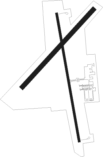
Runway info
Runway 16 / 34  | ||
| length | 1281m (4203ft) | |
| bearing | 173° / 353° | |
| width | 23m (75ft) | |
| surface | concrete | |
| Runway 04 / 22 | ||
| length | 1037m (3402ft) | |
| bearing | 55° / 235° | |
| width | 46m (150ft) | |
| surface | grass | |
Nearby beacons
| code | identifier | dist | bearing | frequency |
|---|---|---|---|---|
| LNK | LINCOLN VORTAC | 17 | 81° | 116.10 |
| LN | POTTS (LINCOLN) NDB | 17.2 | 109° | 385 |
| JYR | YORK NDB | 23.1 | 274° | 257 |
| FMZ | BEKLOF (FAIRMONT) NDB | 26.6 | 239° | 392 |
| AHQ | WAHOO NDB | 32.2 | 54° | 400 |
| OLU | COLUMBUS VOR/DME | 36.6 | 338° | 111.80 |
| BIE | BEATRICE VOR | 37.4 | 148° | 110.60 |
| PLT | PLATTE CENTER (COLUMBUS) NDB | 39.8 | 337° | 407 |
| FBY | FAIRBURY NDB | 41.4 | 185° | 293 |
| SCB | SCRIBNER VOR/DME | 49.4 | 33° | 111 |
| PWE | PAWNEE CITY VORTAC | 57.3 | 126° | 112.40 |
Instrument approach procedures
| runway | airway (heading) | route (dist, bearing) |
|---|---|---|
| RW16 | APIKY (173°) | APIKY 3300ft |
| RW16 | DWELL (219°) | DWELL VOSTE (5mi, 243°) 3300ft APIKY (5mi, 266°) 3300ft |
| RW16 | ITBEW (113°) | ITBEW SORGE (13mi, 94°) 3300ft APIKY (5mi, 86°) 3300ft |
| RNAV | APIKY 3300ft ECHER (5mi, 173°) 3100ft CETRI (3mi, 173°) 2100ft KSWT (2mi, 173°) 1535ft AJADI (11mi, 173°) 3300ft AJADI (turn) | |
| RW34 | AJADI (353°) | AJADI 3300ft |
| RW34 | LNK (261°) | LNK AYEGI (18mi, 225°) 3600ft AJADI (5mi, 266°) 3300ft |
| RW34 | TEVUW (60°) | TEVUW ECEYO (11mi, 88°) 4000ft AJADI (5mi, 86°) 3300ft |
| RNAV | AJADI 3300ft COKET (5mi, 353°) 3300ft IXISE (4mi, 353°) 2080ft KSWT (2mi, 352°) 1546ft APIKY (10mi, 353°) 3300ft APIKY (turn) |
Disclaimer
The information on this website is not for real aviation. Use this data with the X-Plane flight simulator only! Data taken with kind consent from X-Plane 12 source code and data files. Content is subject to change without notice.