Sweetwater - Avenger Fld
Airport details
| Country | United States of America |
| State | Texas |
| Region | K4 |
| Airspace | Ft Worth Ctr |
| Municipality | Nolan County |
| Elevation | 2376ft (724m) |
| Timezone | GMT -6 |
| Coordinates | 32.46736, -100.46655 |
| Magnetic var | |
| Type | land |
| Available since | X-Plane v10.40 |
| ICAO code | KSWW |
| IATA code | SWW |
| FAA code | SWW |
Communication
| Avenger Fld AWOS 3 | 119.025 |
| Avenger Fld CTAF/UNICOM | 122.800 |
| Avenger Fld ABILENE Approach/Departure | 127.200 |
Nearby Points of Interest:
Scott-Majors House
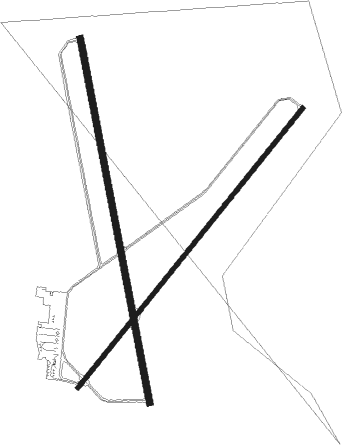
Runway info
Runway 17 / 35  | ||
| length | 1781m (5843ft) | |
| bearing | 173° / 353° | |
| width | 30m (100ft) | |
| surface | asphalt | |
| blast zone | 5m (16ft) / 0m (0ft) | |
| Runway 4 / 22 | ||
| length | 1725m (5659ft) | |
| bearing | 48° / 228° | |
| width | 23m (75ft) | |
| surface | asphalt | |
| blast zone | 0m (0ft) / 3m (10ft) | |
Nearby beacons
| code | identifier | dist | bearing | frequency |
|---|---|---|---|---|
| SDR | SNYDER NDB | 28 | 296° | 359 |
| ABI | ABILENE VORTAC | 30.5 | 89° | 113.70 |
| DYS | DYESS (ABILENE) TACAN | 31 | 95° | 133.60 |
| TQA | TUSCOLA (ABILENE) VOR/DME | 35.7 | 110° | 111.60 |
| AB | TOMHI (ABILENE) NDB | 41.4 | 102° | 353 |
Instrument approach procedures
| runway | airway (heading) | route (dist, bearing) |
|---|---|---|
| RW04 | LORAN (81°) | LORAN OKWOR (7mi, 170°) 4400ft OKWOR (turn) 4400ft |
| RNAV | OKWOR 4400ft WATUV (7mi, 48°) 4000ft ALATE (3mi, 48°) 3020ft KSWW (2mi, 46°) 2420ft (5935mi, 108°) 2630ft AWBIR (5925mi, 288°) 4400ft AWBIR (turn) | |
| RW17 | ABI (269°) | ABI LNDAA (27mi, 294°) 4400ft TORYO (8mi, 265°) 4400ft |
| RW17 | SHEPP (298°) | SHEPP TORYO (37mi, 313°) 4400ft TORYO (turn) 4400ft |
| RW17 | WEEPE (85°) | WEEPE EDWNN (25mi, 58°) 4400ft TORYO (8mi, 85°) 4400ft |
| RNAV | TORYO 4400ft HELBI (7mi, 172°) 4000ft HUSDO (3mi, 173°) 2920ft KSWW (2mi, 170°) 2381ft (5935mi, 108°) 2614ft WOGUG (5935mi, 288°) 4400ft WOGUG (turn) | |
| RW22 | ABI (269°) | ABI AWBIR (23mi, 288°) 4400ft |
| RW22 | LORAN (81°) | LORAN AWBIR (21mi, 63°) 4400ft AWBIR (turn) 4400ft |
| RNAV | AWBIR 4400ft HOBKU (7mi, 228°) 4000ft LOKEC (3mi, 228°) 2880ft KSWW (2mi, 231°) 2377ft (5935mi, 108°) 2587ft OKWOR (5944mi, 288°) 4400ft OKWOR (turn) | |
| RW35 | SHEPP (298°) | SHEPP WOGUG (22mi, 275°) 4400ft |
| RW35 | TREAT (270°) | TREAT WOGUG (20mi, 236°) 4400ft WOGUG (turn) 4400ft |
| RW35 | WEEPE (85°) | WEEPE HOPOS (25mi, 110°) 4400ft WOGUG (8mi, 85°) 4400ft |
| RNAV | WOGUG 4400ft JOTRA (7mi, 353°) 4000ft KOPPE (3mi, 353°) 3020ft KSWW (2mi, 355°) 2421ft (5935mi, 108°) 2619ft TORYO (5935mi, 288°) 4400ft TORYO (turn) |
Disclaimer
The information on this website is not for real aviation. Use this data with the X-Plane flight simulator only! Data taken with kind consent from X-Plane 12 source code and data files. Content is subject to change without notice.