Toledo - Toledo Executive
Airport details
| Country | United States of America |
| State | Ohio |
| Region | K5 |
| Airspace | Cleveland Ctr |
| Municipality | Wood County |
| Elevation | 622ft (190m) |
| Timezone | GMT -5 |
| Coordinates | 41.56495, -83.48222 |
| Magnetic var | |
| Type | land |
| Available since | X-Plane v10.40 |
| ICAO code | KTDZ |
| IATA code | TDZ |
| FAA code | TDZ |
Communication
| Toledo Executive ASOS | 121.575 |
| Toledo Executive CTAF/UNICOM | 123.050 |
| Toledo Executive TOLEDO Approach/Departure | 126.100 |
Nearby Points of Interest:
Tower on the Maumee
-Edward D. Libbey House
-Libbey High School
-Lucas County Courthouse and Jail
-James M. Ashley and Thomas W.L. Ashley United States Courthouse
-Old School Privy
-Hull-Wolcott House
-Toledo Yacht Club
-Georg Cronenwett House
-Christopher C. Layman Law Office
-Inverness Club
-Fallen Timbers Battlefield
-North Maumee Bay Archeological District
-Dodge Site
-Wood County Courthouse and Jail
-Floral Hall
-Soldiers and McKinley Memorial Parkways
-Spiegel Grove
-Sandusky County Jail and Sheriff's House
-Joseph and Rachel Bartlett House
-Frederick Fabing House
-Old Village Historic District
-Weis Manufacturing Company building
-Sawyer House
-Rudolph Nims House
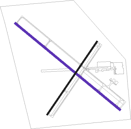
Runway info
| Runway 14 / 32 | ||
| length | 1777m (5830ft) | |
| bearing | 126° / 306° | |
| width | 30m (100ft) | |
| surface | asphalt | |
| displ threshold | 69m (226ft) / 105m (344ft) | |
Runway 4 / 22  | ||
| length | 1159m (3802ft) | |
| bearing | 47° / 227° | |
| width | 23m (75ft) | |
| surface | asphalt | |
| displ threshold | 34m (112ft) / 119m (390ft) | |
Nearby beacons
| code | identifier | dist | bearing | frequency |
|---|---|---|---|---|
| TOL | TOLEDO TACAN | 14.3 | 275° | 112.50 |
| TO | TOPHR (TOLEDO) NDB | 19.7 | 268° | 219 |
| PCW | PORT CLINTON NDB | 27.7 | 94° | 423 |
| CRL | CARLETON VOR/DME | 29 | 3° | 115.70 |
| TII | TIFFIN NDB | 30.7 | 150° | 269 |
| ADG | ADRIAN NDB | 32.3 | 297° | 278 |
| DT | REVUP (DETROIT) NDB | 33.4 | 5° | 388 |
| TCU | TECUMSEH NDB | 33.4 | 319° | 239 |
| RYS | GROSSE ILE (DETROIT) NDB | 35.4 | 32° | 419 |
| FBC | FLAG CITY VORTAC | 38.6 | 204° | 108.20 |
| DXO | DETROIT VOR/DME | 39.2 | 10° | 113.40 |
| DM | SPENC (DETROIT) NDB | 41.2 | 23° | 223 |
| SVM | SALEM VORTAC | 50.9 | 352° | 114.30 |
| QG | WINDSOR NDB | 52.6 | 39° | 353 |
| MFD | MANSFIELD VORTAC | 58 | 128° | 108.80 |
| BUD | BUCKEYE (MARION) VOR | 60 | 156° | 109.80 |
| JXN | DME | 60.3 | 305° | 115.45 |
Instrument approach procedures
| runway | airway (heading) | route (dist, bearing) |
|---|---|---|
| RW04 | VEFDO (47°) | VEFDO 2300ft |
| RNAV | VEFDO 2300ft WIGRI (8mi, 47°) 2200ft ZAVRI (2mi, 47°) 1320ft KTDZ (2mi, 46°) 658ft (5113mi, 116°) 1100ft VEFDO (5120mi, 296°) 2300ft VEFDO (turn) | |
| RW32 | VASHO (283°) | VASHO WIMLU (16mi, 271°) 2300ft |
| RW32 | WIMLU (306°) | WIMLU 2300ft |
| RNAV | WIMLU 2300ft HOKVO (5mi, 306°) 2200ft CETYA (3mi, 306°) 1160ft KTDZ (2mi, 306°) 666ft (5113mi, 116°) 1100ft WIMLU (5105mi, 296°) 2300ft WIMLU (turn) |
Disclaimer
The information on this website is not for real aviation. Use this data with the X-Plane flight simulator only! Data taken with kind consent from X-Plane 12 source code and data files. Content is subject to change without notice.