Tomahawk - Tomahawk Rgnl
Airport details
| Country | United States of America |
| State | Wisconsin |
| Region | K5 |
| Airspace | Minneapolis Ctr |
| Municipality | Town of Wilson |
| Elevation | 1485ft (453m) |
| Timezone | GMT -6 |
| Coordinates | 45.46936, -89.80489 |
| Magnetic var | |
| Type | land |
| Available since | X-Plane v10.40 |
| ICAO code | KTKV |
| IATA code | n/a |
| FAA code | TKV |
Communication
| Tomahawk Rgnl AWOS 3 | 118.250 |
| Tomahawk Rgnl CTAF/UNICOM | 122.800 |
Nearby Points of Interest:
T.B. Scott Free Library
-First Street Bridge (Merrill, Wisconsin)
-Merrill City Hall
-First National Bank
-Oneida County Courthouse
-Solon and Mathilda Sutliff House
-Fromm Brothers Fur and Ginseng Farm
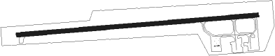
Runway info
| Runway 9 / 27 | ||
| length | 1343m (4406ft) | |
| bearing | 90° / 270° | |
| width | 23m (75ft) | |
| surface | asphalt | |
Nearby beacons
| code | identifier | dist | bearing | frequency |
|---|---|---|---|---|
| RH | ARSHA (RHINELANDER) NDB | 12.3 | 50° | 272 |
| RHI | RHINELANDER VOR/DME | 17.6 | 65° | 109.20 |
| DO | DOUGY (MINOCQUA WOODRUFF) NDB | 22.1 | 12° | 236 |
| AUW | WAUSAU VOR/DME | 38.5 | 161° | 111.60 |
| RXW | WATERSMEET NDB | 53.8 | 33° | 407 |
Instrument approach procedures
| runway | airway (heading) | route (dist, bearing) |
|---|---|---|
| RW09 | BAITS (74°) | BAITS YELUD (13mi, 58°) 4000ft |
| RW09 | KRSMS (152°) | KRSMS WIMRA (20mi, 193°) 5200ft YELUD (6mi, 179°) 4000ft |
| RNAV | YELUD 4000ft BUVNE (7mi, 90°) 3100ft ZOGIB (3mi, 90°) 2080ft KTKV (2mi, 90°) 1508ft (5397mi, 117°) 1887ft JAKLI (5386mi, 297°) 4000ft JAKLI (turn) | |
| RW27 | RHI (245°) | RHI JAKLI (10mi, 205°) 4000ft |
| RW27 | ZITOD (283°) | ZITOD JAKLI (12mi, 296°) 4000ft |
| RNAV | JAKLI 4000ft AXOVE (6mi, 270°) 3100ft YULUK (2mi, 270°) 2380ft KTKV (3mi, 270°) 1525ft (5397mi, 117°) 1840ft YELUD (5409mi, 297°) 4000ft YELUD (turn) |
Disclaimer
The information on this website is not for real aviation. Use this data with the X-Plane flight simulator only! Data taken with kind consent from X-Plane 12 source code and data files. Content is subject to change without notice.