Twentynine Palms
Airport details
| Country | United States of America |
| State | California |
| Region | K2 |
| Airspace | Los Angeles Ctr |
| Municipality | San Bernardino County |
| Elevation | 1887ft (575m) |
| Timezone | GMT -8 |
| Coordinates | 34.13158, -115.94581 |
| Magnetic var | |
| Type | land |
| Available since | X-Plane v10.40 |
| ICAO code | KTNP |
| IATA code | TNP |
| FAA code | TNP |
Communication
| Twentynine Palms CTAF/UNICOM | 122.800 |
Nearby Points of Interest:
Desert Queen Mine
-Keys Desert Queen Ranch
-Cow Camp
-Ryan House and Lost Horse Well
-Integratron
-Kenaston House
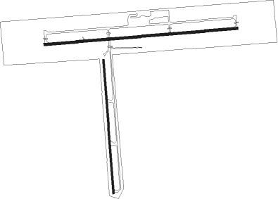
Runway info
Runway 8 / 26  | ||
| length | 1682m (5518ft) | |
| bearing | 90° / 270° | |
| width | 23m (75ft) | |
| surface | asphalt | |
| blast zone | 63m (207ft) / 62m (203ft) | |
| Runway 17 / 35 | ||
| length | 1163m (3816ft) | |
| bearing | 180° / 0° | |
| width | 15m (50ft) | |
| surface | asphalt | |
| blast zone | 71m (233ft) / 0m (0ft) | |
Nearby beacons
| code | identifier | dist | bearing | frequency |
|---|---|---|---|---|
| TNP | TWENTYNINE PALMS VORTAC | 8.8 | 96° | 114.20 |
| PSP | PALM SPRINGS VORTAC | 28.7 | 242° | 115.50 |
| TRM | THERMAL VORTAC | 32 | 203° | 116.20 |
| HEC | HECTOR VORTAC | 47.4 | 322° | 112.70 |
| DAG | DAGGETT VORTAC | 58.8 | 323° | 113.20 |
| JLI | JULIAN VORTAC | 67.5 | 213° | 114 |
| GFS | GOFFS VORTAC | 71 | 38° | 114.40 |
Instrument approach procedures
| runway | airway (heading) | route (dist, bearing) |
|---|---|---|
| RW26 | JEHLI (273°) | JEHLI WISIR (2mi, 261°) 6000ft |
| RW26 | TNP (276°) | TNP WISIR (8mi, 93°) 6000ft WISIR (turn) 6000ft |
| RNAV | WISIR 6000ft HURDI (6mi, 276°) 4800ft ZEDAB (4mi, 276°) 3800ft JUXIX (5mi, 276°) 1988ft (6679mi, 106°) 2288ft WISIR (6665mi, 286°) 6000ft WISIR (turn) |
Disclaimer
The information on this website is not for real aviation. Use this data with the X-Plane flight simulator only! Data taken with kind consent from X-Plane 12 source code and data files. Content is subject to change without notice.