Troy - Troy Muni
Airport details
| Country | United States of America |
| State | Alabama |
| Region | K7 |
| Airspace | Atlanta Ctr |
| Municipality | Troy |
| Elevation | 395ft (120m) |
| Timezone | GMT -5 |
| Coordinates | 31.86000, -86.01389 |
| Magnetic var | |
| Type | land |
| Available since | X-Plane v10.40 |
| ICAO code | KTOI |
| IATA code | TOI |
| FAA code | TOI |
Communication
| Troy Muni ATIS | 120.925 |
| Troy Muni CTAF/UNICOM | 122.800 |
| Troy Muni Ground Control | 121.900 |
| Troy Muni Tower | 124.300 |
| Troy Muni CAIRNS Approach/Departure | 121.100 |
Approach frequencies
| ILS-cat-I | RW07 | 108.9 | 18.00mi |
| 3° GS | RW07 | 108.9 | 18.00mi |
Nearby Points of Interest:
College Street Historic District
-Luverne Historic District
-Kirkpatrick House
-Sardis Baptist Church
-Brantley Historic District
-Foster House
-James Spullock Williamson House
-Coffee County Courthouse
-Merritt School
-Henry D. Clayton House
-Miller-Martin Town House
-Grace Episcopal Church
-Petty-Roberts-Beatty House
-Fendall Hall
-Dickenson House
-Graydon House
-Greenville City Hall (Greenville, Alabama)
-Gaston-Perdue House
-Buell-Stallings-Stewart House
-W.S. Blackwell House
-Butler Chapel A.M.E. Zion Church
-Evens–McMullan House
-Edgewood
-Cloverdale Historic District
-Garden District
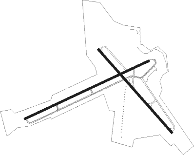
Runway info
Runway 14 / 32  | ||
| length | 1533m (5030ft) | |
| bearing | 138° / 318° | |
| width | 30m (100ft) | |
| surface | asphalt | |
| Runway 7 / 25 | ||
| length | 1890m (6201ft) | |
| bearing | 72° / 252° | |
| width | 30m (100ft) | |
| surface | asphalt | |
| blast zone | 0m (0ft) / 91m (299ft) | |
Nearby beacons
| code | identifier | dist | bearing | frequency |
|---|---|---|---|---|
| TOI | BLOOD (TROY) NDB | 5 | 252° | 365 |
| MGM | MONTGOMERY VORTAC | 26.7 | 320° | 112.10 |
| BVG | BOLL WEEVIL (ENTERPRISE) NDB | 31.3 | 176° | 352 |
| LOR | LOWE (FORT RUCKER) NDB | 32.9 | 152° | 269 |
| EDN | ENTERPRISE VOR | 34.3 | 169° | 116.60 |
| HYE | HANCHEY (FT RUCKER) NDB | 34.4 | 143° | 221 |
| HEY | HANCHEY (FT RUCKER) VOR | 34.5 | 143° | 110.60 |
| MXF | MAXWELL (MONTGOMERY) TACAN | 36 | 326° | 115 |
| MG | MARRA (MONTGOMERY) NDB | 37 | 312° | 245 |
| OZR | CAIRNS (FT RUCKER) VOR/DME | 38.4 | 154° | 111.20 |
| JUY | JUDD (ANDALUSIA) NDB | 38.5 | 214° | 264 |
| OZ | RUCKR (FT RUCKER) NDB | 39.4 | 163° | 212 |
| TGE | TUSKEGEE VOR/DME | 41.4 | 29° | 117.30 |
| EUF | EUFAULA VORTAC | 45.3 | 84° | 109.20 |
| RRS | WIREGRASS (DOTHAN) VORTAC | 45.6 | 135° | 111.60 |
| SE | POLLK (SELMA) NDB | 52.6 | 294° | 344 |
| AWS | LAWSON (COLUMBUS) NDB | 56.7 | 66° | 335 |
| CS | FENIX (COLUMBUS) NDB | 60.8 | 59° | 355 |
| CSG | COLUMBUS VORTAC | 67.9 | 53° | 117.10 |
| SMY | SOYYA (MARIANNA) NDB | 71.8 | 141° | 329 |
Instrument approach procedures
| runway | airway (heading) | route (dist, bearing) |
|---|---|---|
| RW07 | MAKEY (73°) | MAKEY 2200ft |
| RNAV | MAKEY 2200ft UCASI (7mi, 72°) 1900ft OWFEB (2mi, 72°) 1120ft KTOI (3mi, 74°) 425ft (5202mi, 110°) 1300ft MAKEY (5213mi, 290°) 2200ft MAKEY (turn) | |
| RW14 | SHADY (159°) | SHADY 2400ft |
| RNAV | SHADY 2400ft CELUT (7mi, 173°) 2200ft IYUKO (3mi, 142°) 1260ft KTOI (3mi, 144°) 447ft (5202mi, 110°) 797ft IGUBE (5194mi, 290°) 2600ft IGUBE (turn) | |
| RW25 | FEPEN (252°) | FEPEN 2600ft |
| RNAV | FEPEN 2600ft PABSE (7mi, 252°) 1900ft JANVU (3mi, 252°) 1060ft KTOI (2mi, 251°) 439ft (5202mi, 110°) 647ft MAKEY (5213mi, 290°) 2200ft MAKEY (turn) | |
| RW32 | IGUBE (318°) | IGUBE 2600ft |
| RNAV | IGUBE 2600ft JALOV (6mi, 319°) 2200ft RECRO (3mi, 319°) 1220ft KTOI (3mi, 315°) 415ft (5202mi, 110°) 1200ft IGUBE (5194mi, 290°) 2600ft IGUBE (turn) |
Disclaimer
The information on this website is not for real aviation. Use this data with the X-Plane flight simulator only! Data taken with kind consent from X-Plane 12 source code and data files. Content is subject to change without notice.