Temple - Draughon-miller Rgnl
Airport details
| Country | United States of America |
| State | Texas |
| Region | K4 |
| Airspace | Houston Oceanic Ctr |
| Municipality | Temple |
| Elevation | 682ft (208m) |
| Timezone | GMT -6 |
| Coordinates | 31.15190, -97.40766 |
| Magnetic var | |
| Type | land |
| Available since | X-Plane v10.40 |
| ICAO code | KTPL |
| IATA code | TPL |
| FAA code | TPL |
Communication
| Draughon-Miller Rgnl AWOS-3 | 134.975 |
| Draughon-Miller Rgnl CTAF/UNICOM | 123.000 |
| Draughon-Miller Rgnl Gray Approach Control | 120.075 |
| Draughon-Miller Rgnl Gray Departure Control | 120.075 |
Approach frequencies
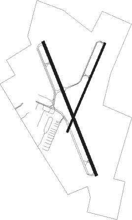
| ILS-cat-I | RW15 | 111.5 | 18.00mi |
| 2.9° GS | RW15 | 111.5 | 18.00mi |
Nearby Points of Interest:
V. R. Means House
-First Christian Church Parsonage
-Barton House
-George Washington Baines House
-The Church of the Visitation
-Westphalia
-Bartlett Commercial Historic District
-Coryell County Courthouse
-Waco High School
-Praetorian Building
-Dr. Nathan and Lula Cass House
-Milam County Courthouse and Jail
-Hugh Roy and Lillie Cullen Building
-Williamson County Courthouse Historic District
-Georgetown Light and Water Works
-Harper-Chesser House
-Belford Historic District
-Hutto Commercial Historic District

Nearby beacons
| code | identifier | dist | bearing | frequency |
|---|---|---|---|---|
| TPL | DME | 3.5 | 343° | 110.40 |
| IL | IRESH (KILLEEN) NDB | 17.2 | 247° | 278 |
| GRK | GRAY (FORT HOOD) VOR/DME | 22 | 254° | 111.80 |
| ROB | ROBINSON (WACO) NDB | 27.3 | 44° | 400 |
| ACT | WACO VORTAC | 31.4 | 15° | 115.30 |
| AGJ | GOOCH SPRINGS VORTAC | 37.7 | 273° | 112.50 |
| CWK | CENTEX VORTAC | 46.8 | 189° | 112.80 |
| GNL | GROESBECK (MEXIA) VOR/DME | 51 | 63° | 108.80 |
| LXY | MEXIA NDB | 54.4 | 61° | 329 |
| CLL | COLLEGE STATION VORTAC | 60.5 | 119° | 113.30 |
| CGQ | POWELL (CORSICANA) NDB | 74.3 | 47° | 344 |
Instrument approach procedures
| runway | airway (heading) | route (dist, bearing) |
|---|---|---|
| RW15 | ACT (195°) | ACT IHSAZ (22mi, 213°) 3000ft |
| RW15 | BARBA (283°) | BARBA IHSAZ (21mi, 309°) 3000ft IHSAZ (turn) 3000ft |
| RW15 | CONRA (359°) | CONRA IHSAZ (21mi, 348°) 3000ft IHSAZ (turn) 3000ft |
| RNAV | IHSAZ 3000ft IFDOH (6mi, 160°) 2400ft CUMIX (3mi, 160°) 1240ft KTPL (2mi, 158°) 727ft (5786mi, 108°) 882ft FADXY (5784mi, 288°) BARBA (10mi, 79°) 3600ft BARBA (turn) 3600ft | |
| RW33 | BARBA (283°) | BARBA HUHIF (7mi, 209°) 3000ft ESWUL (5mi, 255°) 3000ft |
| RW33 | DARTE (7°) | DARTE FBURG (11mi, 6°) 3000ft ESWUL (5mi, 75°) 3000ft |
| RW33 | SLIMM (67°) | SLIMM FBURG (41mi, 80°) 3100ft ESWUL (5mi, 75°) 3000ft |
| RNAV | ESWUL 3000ft FADXY (6mi, 340°) 2300ft IYUJY (3mi, 340°) 1260ft KTPL (2mi, 342°) 719ft (5786mi, 108°) 874ft IHSAZ (5788mi, 288°) 3000ft IHSAZ (turn) |
Disclaimer
The information on this website is not for real aviation. Use this data with the X-Plane flight simulator only! Data taken with kind consent from X-Plane 12 source code and data files. Content is subject to change without notice.