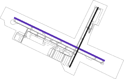
Truckee - Truckee Tahoe
Airport details
| Country | United States of America |
| State | California |
| Region | K2 |
| Airspace | Oakland Ctr |
| Municipality | Truckee |
| Elevation | 5897ft (1797m) |
| Timezone | GMT -8 |
| Coordinates | 39.32095, -120.15065 |
| Magnetic var | |
| Type | land |
| Available since | X-Plane v10.40 |
| ICAO code | KTRK |
| IATA code | TKF |
| FAA code | TRK |
Communication
| Truckee Tahoe AWOS 3 | 118.000 |
| Truckee Tahoe CTAF | 120.575 |
| Truckee Tahoe UNICOM | 122.950 |
| Truckee Tahoe Ground Control | 118.300 |
| Truckee Tahoe Tower | 120.575 |
| Truckee Tahoe Approach/Departure | 127.950 |
Nearby Points of Interest:
Commercial Row-Brickelltown Historic District
-Kruger House
-Donner Memorial State Park
-1872 California-Nevada State Boundary Marker
-Twaddle-Pedroli Ranch
-Old Winters Ranch/Winters Mansion
-Galena Creek Schoolhouse
-Ed Z'berg Sugar Pine Point State Park
-Marlette Lake Water System
-Lakeview House
-Sierraville School
-De’ek wadapush
-California Building
-Greystone Castle
-Veterans of Foreign Wars Building
-W.E. Barnard House
-Patrick Ranch House (Reno, Nevada)
-J. Clarence Kind House
-Lake Mansion
-Glendale School
-Pearl Upson House
-Peleg Brown Ranch
-Miller-Rowe-Holgate House
-Luella Garvey House
-Francis G. Newlands Home
Nearby beacons
| code | identifier | dist | bearing | frequency |
|---|---|---|---|---|
| SWR | SQUAW VALLEY(SOUTH LAKE T VOR/DME | 10 | 220° | 113.20 |
| FMG | MUSTANG (RENO) VORTAC | 26.1 | 67° | 117.90 |
| HNW | HANGTOWN (PLACERVILLE) VOR/DME | 45.4 | 225° | 115.50 |
| AHC | AMEDEE (HERLONG) VOR/DME | 56.8 | 360° | 109 |
Departure and arrival routes
| Transition altitude | 18000ft |
| Transition level | 18000ft |
| SID end points | distance | outbound heading | |
|---|---|---|---|
| RW02 | |||
| TAHOE1 | 23mi | 273° | |
| RW29 | |||
| TAHOE1 | 23mi | 273° | |
Instrument approach procedures
| runway | airway (heading) | route (dist, bearing) |
|---|---|---|
| RW11 | FMG (247°) | FMG ALANT (24mi, 281°) 11400ft LEKYI (11mi, 244°) 10800ft |
| RW11 | SIGNA (93°) | SIGNA RONND (10mi, 30°) 11400ft LEKYI (9mi, 81°) 10800ft |
| RW11 | SWR (40°) | SWR LEKYI (21mi, 346°) 11400ft LEKYI (turn) 10800ft |
| RW11 | TRUCK (175°) | TRUCK LEKYI (10mi, 295°) 11400ft LEKYI (turn) 10800ft |
| RNAV | LEKYI 10800ft FAMPU (6mi, 142°) 9700ft SUYYO (3mi, 133°) 8480ft MARDR (6mi, 133°) 6254ft (6779mi, 108°) 6304ft KEBTE (6779mi, 288°) LEKYI (6mi, 291°) 12000ft LEKYI (turn) 12000ft | |
| RW20 | FMG (247°) | FMG WUDPA (9mi, 283°) 12000ft AWEGA (8mi, 282°) 12000ft |
| RW20 | SIGNA (93°) | SIGNA ALVVA (27mi, 53°) 12000ft AWEGA (10mi, 102°) 12000ft |
| RNAV | AWEGA 12000ft OSTIE (6mi, 199°) 10000ft LUMMO (2mi, 199°) 9500ft ZILTO (1mi, 200°) 8960ft BOFFS (3mi, 200°) 7700ft YAKYU (1mi, 200°) 7200ft WINUB (3mi, 200°) 6246ft (6777mi, 108°) 6304ft GRIOT (6775mi, 288°) AWEGA (11mi, 37°) 12000ft AWEGA (turn) 12000ft | |
| RWNVA | SIGNA (93°) | SIGNA GEGVY (10mi, 101°) 10000ft LIDGE (7mi, 90°) 9500ft |
| RNAV | LIDGE 9500ft ASETE (2mi, 90°) 9100ft NEDVE (4mi, 76°) 7700ft (6778mi, 108°) 7800ft KEBTE (6779mi, 288°) LEKYI (6mi, 291°) 12000ft LEKYI (turn) 12000ft |
Disclaimer
The information on this website is not for real aviation. Use this data with the X-Plane flight simulator only! Data taken with kind consent from X-Plane 12 source code and data files. Content is subject to change without notice.

