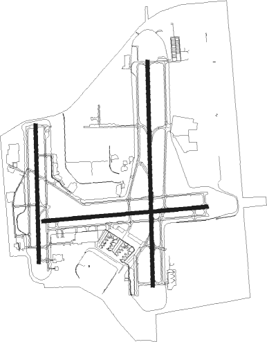
Tulsa - Tulsa Intl
Airport details
| Country | United States of America |
| State | Oklahoma |
| Region | K4 |
| Airspace | Kansas City Ctr |
| Municipality | Tulsa |
| Elevation | 675ft (206m) |
| Timezone | GMT -6 |
| Coordinates | 36.19839, -95.88811 |
| Magnetic var | |
| Type | land |
| Available since | X-Plane v10.40 |
| ICAO code | KTUL |
| IATA code | TUL |
| FAA code | TUL |
Communication
| Tulsa Intl ATIS | 124.900 |
| Tulsa Intl UNICOM | 122.950 |
| Tulsa Intl Clearance DEL | 134.050 |
| Tulsa Intl Ground Control | 121.900 |
| Tulsa Intl Tower | 118.700 |
| Tulsa Intl Approach/Departure | 119.100 |
Approach frequencies
| ILS-cat-II | RW36R | 110.3 | 18.00mi |
| ILS-cat-I | RW18L | 109.7 | 18.00mi |
| ILS-cat-I | RW18R | 111.1 | 18.00mi |
| 3° GS | RW36R | 110.3 | 18.00mi |
| 2.7° GS | RW18L | 109.7 | 18.00mi |
| 2.7° GS | RW18R | 111.1 | 18.00mi |
Nearby Points of Interest:
Dawson School
-Sinclair Service Station
-The Church Studio
-Tulsa Fire Alarm Building
-Mid-Continent Tower
-Philtower Building
-Philcade Building
-Oklahoma Natural Gas Company Building
-Mayo Building
-United States Post Office and Courthouse
-Petroleum Building
-James Alexander Veasey House
-Creek Council Oak Tree
-Westhope
-Clinton–Hardy House
-Harwelden Mansion
-McBirney Mansion
-Cities Service Station No. 8
-Riverside Studio
-John Frank House
-First Presbyterian Church
-Foyil Filling Station
-Bank of Bigheart
-Barnsdall Main Street Well Site
-Ed Galloway's Totem Pole Park
Runway info
Nearby beacons
| code | identifier | dist | bearing | frequency |
|---|---|---|---|---|
| TUL | TULSA VORTAC | 4.8 | 91° | 114.40 |
| TU | OILLR (TULSA) NDB | 6 | 180° | 338 |
| GNP | (TULSA) DME | 17.1 | 196° | 110.60 |
| OK | PRESO (OKMULGEE) NDB | 26.7 | 188° | 388 |
| OKM | OKMULGEE VOR/DME | 30.3 | 177° | 114.90 |
| BVO | BARTLESVILLE VOR/DME | 38.7 | 348° | 117.90 |
| BV | DEWIE (BARTLESVILLE) NDB | 38.9 | 349° | 201 |
| HET | HENRYETTA NDB | 48 | 189° | 267 |
| OSW | OSWEGO VOR/DME | 66.3 | 36° | 117.60 |
| SRE | SEMINOLE NDB | 67.5 | 220° | 278 |
Departure and arrival routes
| Transition altitude | 18000ft |
| Transition level | 18000ft |
| SID end points | distance | outbound heading | |
|---|---|---|---|
| RW08 | |||
| TUL9 | 12mi | 269° | |
| RW18 (ALL) | |||
| TUL9 | 12mi | 269° | |
| RW26 | |||
| TUL9 | 12mi | 269° | |
| RW36 (ALL) | |||
| TUL9 | 12mi | 269° | |
| STAR starting points | distance | inbound heading | |
|---|---|---|---|
| RW08 | |||
| VINTA3 | 42.4 | 235° | |
| RW18 (ALL) | |||
| VINTA3 | 42.4 | 235° | |
| RW26 | |||
| VINTA3 | 42.4 | 235° | |
| RW36 (ALL) | |||
| VINTA3 | 42.4 | 235° | |
Instrument approach procedures
| runway | airway (heading) | route (dist, bearing) |
|---|---|---|
| RW08 | HAGIL (89°) | HAGIL 14000ft HAGIL (turn) 3500ft |
| RNAV | HAGIL 3500ft CEBIP (6mi, 89°) 2800ft WIGOX (4mi, 89°) 1380ft KTUL (3mi, 86°) 723ft (5690mi, 111°) 921ft JESON (5677mi, 291°) 3600ft JESON (turn) | |
| RW18L | MUTXU (214°) | MUTXU ORKUC (6mi, 273°) 3500ft |
| RW18L | NUPXA (155°) | NUPXA ORKUC (6mi, 92°) 3500ft |
| RW18L | ORKUC (185°) | ORKUC 3500ft |
| RNAV | ORKUC 3500ft IRUHU (7mi, 184°) 2400ft ERIRE (2mi, 184°) 1700ft KTUL (4mi, 189°) 683ft (5690mi, 111°) 908ft ICECE (5691mi, 291°) 3500ft ICECE (turn) | |
| RW18R | COQXA (150°) | COQXA VIDKY (6mi, 92°) 3500ft |
| RW18R | ERXAV (212°) | ERXAV VIDKY (6mi, 273°) 3500ft |
| RW18R | VIDKY (181°) | VIDKY 3500ft |
| RNAV | VIDKY 3500ft OYAVY (6mi, 184°) 2500ft KTUL (6mi, 177°) 695ft (5690mi, 111°) 918ft SUSNE (5692mi, 291°) 3500ft SUSNE (turn) | |
| RW26 | COPOL (290°) | COPOL JESON (6mi, 359°) 3600ft |
| RW26 | HARSO (250°) | HARSO JESON (6mi, 179°) 3600ft |
| RW26 | JESON (270°) | JESON 3600ft |
| RNAV | JESON 3600ft MIROE (7mi, 270°) 2300ft JETRO (2mi, 270°) 1640ft KTUL (4mi, 272°) 690ft (5690mi, 111°) 852ft HAGIL (5703mi, 291°) 3500ft HAGIL (turn) | |
| RW36L | SUSNE (7°) | SUSNE 3600ft |
| RW36L | WUSPA (36°) | WUSPA SUSNE (6mi, 92°) 3600ft |
| RW36L | ZULEN (336°) | ZULEN SUSNE (6mi, 273°) 3600ft |
| RNAV | SUSNE 3600ft PASIE (7mi, 4°) 2400ft KTUL (6mi, 11°) 727ft (5690mi, 111°) 1078ft AXIWU (5689mi, 291°) 3500ft AXIWU (turn) | |
| RW36R | JABVI (2°) | JABVI 3500ft |
| RW36R | WUFCY (332°) | WUFCY JABVI (6mi, 273°) 3500ft |
| RW36R | ZUXKY (33°) | ZUXKY JABVI (6mi, 92°) 3500ft |
| RNAV | JABVI 3500ft YIVHE (6mi, 4°) 2500ft SOXAE (3mi, 4°) 1400ft KTUL (3mi, 357°) 696ft (5690mi, 111°) 850ft ORKUC (5689mi, 291°) 3500ft ORKUC (turn) |
Disclaimer
The information on this website is not for real aviation. Use this data with the X-Plane flight simulator only! Data taken with kind consent from X-Plane 12 source code and data files. Content is subject to change without notice.

